TopoQuest Logo
Do you find TopoQuest useful?
Help keep TopoQuest running and adding new maps/features by donating!
Bitcoin:  19c7KJd3qBynnjoSw5npx9KScwjBe4ifkT
Litecoin:  LXs6TkuXGGXo1vDsWCkWVdjQX94eUKd6ui
Home View Maps Find Maps Find Places Resources & Links


River Falls, Alabama Topographic Map

USGS Map Title: River Falls, AL
USGS Map MRC: 31086C5
DRG (GeoTIFF) Download: o31086c5.tif


Neighboring USGS Topographic Map Quads:


  Brooks, AL  
31086D6
 

  Red Level, AL  
31086D5
 

  Gantt, AL  
31086D4
 

  Loango, AL  
31086C6
 

  River Falls, AL  
31086C5
 

  Andalusia, AL  
31086C4
 

  Dixie, AL  
31086B6
 

  Carolina, AL  
31086B5
 

  Libertyville, AL  
31086B4


Map MRC Location:

N32°
W87°
N32°
W86°
H8 H7 H6 H5 H4 H3 H2 H1
G8 G7 G6 G5 G4 G3 G2 G1
F8 F7 F6 F5 F4 F3 F2 F1
E8 E7 E6 E5 E4 E3 E2 E1
D8 D7 D6 D5 D4 D3 D2 D1
C8 C7 C6 C5 C4 C3 C2 C1
B8 B7 B6 B5 B4 B3 B2 B1
A8 A7 A6 A5 A4 A3 A2 A1
N31°
W87°
N31°
W86°

River Falls, AL USGS 1:24K Topographic Map Preview:
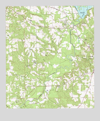
River Falls, AL USGS Topographic Map
Click on map above to begin viewing in our Map Viewer.

This topographic map contains these locations and features:
Feature Name Type Latitude Longitude GNIS ID View Map
Adams CreekStreamN31.3129°W86.5386°112925View Map
Adellum Baptist ChurchChurchN31.2877°W86.5225°112932View Map
Adellum CemeteryCemeteryN31.2868°W86.5227°1730288View Map
Andalusia Country ClubLocaleN31.3154°W86.5125°143029View Map
Andalusia DivisionCivilN31.3293°W86.5245°161609View Map
Andalusia Health Care CenterBuildingN31.3136°W86.5017°2578943View Map
Aughtman PondLakeN31.3059°W86.5818°113279View Map
Barrow PondReservoirN31.2764°W86.5490°113516View Map
BeckPopulated PlaceN31.2563°W86.5847°113776View Map
Bethlehem CemeteryCemeteryN31.3666°W86.6086°114109View Map
Blackmon PondReservoirN31.3081°W86.5834°114446View Map
Bullpen CreekStreamN31.2916°W86.5613°115198View Map
Camp CreekStreamN31.3291°W86.5586°115451View Map
Cedar Grove Church of ChristChurchN31.2802°W86.5436°115780View Map
Center Hill School (historical)SchoolN31.3502°W86.5725°149370View Map
Centerville ChurchChurchN31.3518°W86.5850°115879View Map
Coker Mill CreekStreamN31.2721°W86.5705°116374View Map
Columbia Regional Medical Center (historical)HospitalN31.3135°W86.5027°116458View Map
Covington County JailBuildingN31.3122°W86.5030°2579630View Map
Covington County Sheriff's OfficeBuildingN31.3132°W86.5027°2751990View Map
Dillon ChurchChurchN31.2846°W86.5333°133387View Map
Duns Mill (historical)LocaleN31.3552°W86.5200°133389View Map
Fagins Mills (historical)LocaleN31.2521°W86.6236°133390View Map
Fall CreekStreamN31.2793°W86.5700°118178View Map
First Bethlehem Baptist ChurchChurchN31.3502°W86.5750°118301View Map
Fuqua PondReservoirN31.2716°W86.5675°118765View Map
Gunter Mill CreekStreamN31.3568°W86.5247°119503View Map
Hopewell Baptist ChurchChurchN31.2577°W86.6105°120362View Map
Hopewell School (historical)SchoolN31.2588°W86.6091°133409View Map
Hopewell Volunteer Fire DepartmentBuildingN31.2580°W86.6118°2691246View Map
Martin PondReservoirN31.3156°W86.5668°122336View Map
Montezuma (historical)Populated PlaceN31.3224°W86.5250°133418View Map
Mount Moriah ChurchChurchN31.3343°W86.5030°123249View Map
Mount Olive Church (historical)ChurchN31.3654°W86.6083°133420View Map
New Friendship ChurchChurchN31.2891°W86.6027°152618View Map
New Home CemeteryCemeteryN31.3024°W86.5933°1730305View Map
New Home ChurchChurchN31.3021°W86.5927°123762View Map
New Sweet Home School (historical)SchoolN31.2621°W86.5658°133426View Map
Oak Grove ChurchChurchN31.3218°W86.5902°124067View Map
Patsaliga CreekStreamN31.3674°W86.5211°155187View Map
Pine Level ChurchChurchN31.2907°W86.6100°133432View Map
Point A DamDamN31.3629°W86.5199°129788View Map
Point A LakeReservoirN31.3710°W86.5101°2764757View Map
Posey PondReservoirN31.3576°W86.5910°125189View Map
Presley ChapelChurchN31.3393°W86.6227°153061View Map
Prestwood CreekStreamN31.3399°W86.5330°125255View Map
River FallsPopulated PlaceN31.3529°W86.5391°125660View Map
River Falls Baptist ChurchChurchN31.3510°W86.5405°143047View Map
River Falls CemeteryCemeteryN31.3463°W86.5472°125661View Map
River Falls Police DepartmentBuildingN31.3470°W86.5485°2751733View Map
River Falls Post OfficePost OfficeN31.3487°W86.5405°167649View Map
River Falls Volunteer Fire DepartmentBuildingN31.3469°W86.5485°2331016View Map
Shady Bend CreekStreamN31.2510°W86.6050°160580View Map
Town of River FallsCivilN31.3524°W86.5411°2407223View Map
West Gate Plaza Shopping CenterLocaleN31.3085°W86.5011°143052View Map
West Highland Assembly of God ChurchChurchN31.3222°W86.5062°2580346View Map

Note: Coordinates in the location and feature list above are referenced to NAD83 datum.


Copyright (C) 2008-2024 Ryan Niemi / Sunset Dynamics ... All Rights Reserved