TopoQuest Logo
Do you find TopoQuest useful?
Help keep TopoQuest running and adding new maps/features by donating!
Bitcoin:  19c7KJd3qBynnjoSw5npx9KScwjBe4ifkT
Litecoin:  LXs6TkuXGGXo1vDsWCkWVdjQX94eUKd6ui
Home View Maps Find Maps Find Places Resources & Links


Licking, Missouri Topographic Map

USGS Map Title: Licking, MO
USGS Map MRC: 37091D7
DRG (GeoTIFF) Download: o37091d7.tif


Neighboring USGS Topographic Map Quads:


  Beulah, MO  
37091E8
 

  Maples, MO  
37091E7
 

  Rhyse, MO  
37091E6
 

  Prescott, MO  
37091D8
 

  Licking, MO  
37091D7
 

  Montauk, MO  
37091D6
 

  Houston, MO  
37091C8
 

  Raymondville, MO  
37091C7
 

  Hartshorn, MO  
37091C6


Map MRC Location:

N38°
W92°
N38°
W91°
H8 H7 H6 H5 H4 H3 H2 H1
G8 G7 G6 G5 G4 G3 G2 G1
F8 F7 F6 F5 F4 F3 F2 F1
E8 E7 E6 E5 E4 E3 E2 E1
D8 D7 D6 D5 D4 D3 D2 D1
C8 C7 C6 C5 C4 C3 C2 C1
B8 B7 B6 B5 B4 B3 B2 B1
A8 A7 A6 A5 A4 A3 A2 A1
N37°
W92°
N37°
W91°

Licking, MO USGS 1:24K Topographic Map Preview:
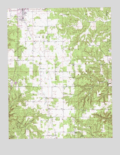
Licking, MO USGS Topographic Map
Click on map above to begin viewing in our Map Viewer.

This topographic map contains these locations and features:
Feature Name Type Latitude Longitude GNIS ID View Map
Ajee SpringSpringN37.4223°W91.7759°713178View Map
Boone Creek ChurchChurchN37.4423°W91.8360°714534View Map
Cavanass School (historical)SchoolN37.4509°W91.8349°735324View Map
City of LickingCivilN37.4992°W91.8617°2395703View Map
Cole Hole HollowValleyN37.3978°W91.8743°749413View Map
Gregory HollowValleyN37.3762°W91.7738°718863View Map
LickingPopulated PlaceN37.4995°W91.8571°735692View Map
Licking Police DepartmentBuildingN37.4981°W91.8572°2752555View Map
Licking Post OfficePost OfficeN37.4977°W91.8572°2782896View Map
Licking Volunteer Fire DepartmentBuildingN37.4977°W91.8552°2620353View Map
MahanPopulated PlaceN37.4037°W91.8271°735325View Map
Mahan CemeteryCemeteryN37.4034°W91.8124°721755View Map
Maxton HollowValleyN37.4228°W91.7743°721995View Map
Mounty SpringSpringN37.4453°W91.7629°723000View Map
Mounty Spring HollowValleyN37.4303°W91.7568°723001View Map
OscarPopulated PlaceN37.4142°W91.8304°723867View Map
Presser CemeteryCemeteryN37.4445°W91.7899°724914View Map
Shipp SchoolSchoolN37.4459°W91.7957°726388View Map
Split Limb SchoolSchoolN37.4017°W91.7865°726866View Map
Upper Bean Creek SchoolSchoolN37.4939°W91.8093°728068View Map
Vollmar SchoolSchoolN37.3784°W91.8282°728221View Map
Wildwood ChurchChurchN37.3809°W91.7965°728850View Map

Note: Coordinates in the location and feature list above are referenced to NAD83 datum.


Copyright (C) 2008-2025 Ryan Niemi / Sunset Dynamics ... All Rights Reserved