TopoQuest Logo
Do you find TopoQuest useful?
Help keep TopoQuest running and adding new maps/features by donating!
Bitcoin:  19c7KJd3qBynnjoSw5npx9KScwjBe4ifkT
Litecoin:  LXs6TkuXGGXo1vDsWCkWVdjQX94eUKd6ui
Home View Maps Find Maps Find Places Resources & Links


Bass Harbor, Maine Topographic Map

USGS Map Title: Bass Harbor, ME
USGS Map MRC: 44068B3
DRG (GeoTIFF) Download: o44068b3.tif


Neighboring USGS Topographic Map Quads:


  Bartlett Island, ME  
44068C4
 

  Southwest Harbor, ME  
44068C3
 

  Seal Harbor, ME  
44068C2
 

  Swans Island, ME  
44068B4
 

  Bass Harbor, ME  
44068B3
 

  Baker Island, ME  
44068B2
 

  Johns Island, ME  
44068A4
 

  Frenchboro, ME  
44068A3


Map MRC Location:

N45°
W69°
N45°
W68°
H8 H7 H6 H5 H4 H3 H2 H1
G8 G7 G6 G5 G4 G3 G2 G1
F8 F7 F6 F5 F4 F3 F2 F1
E8 E7 E6 E5 E4 E3 E2 E1
D8 D7 D6 D5 D4 D3 D2 D1
C8 C7 C6 C5 C4 C3 C2 C1
B8 B7 B6 B5 B4 B3 B2 B1
A8 A7 A6 A5 A4 A3 A2 A1
N44°
W69°
N44°
W68°

Bass Harbor, ME USGS 1:24K Topographic Map Preview:
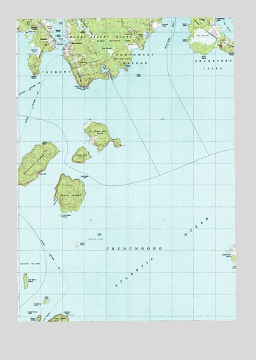
Bass Harbor, ME USGS Topographic Map
Click on map above to begin viewing in our Map Viewer.

This topographic map contains these locations and features:
Feature Name Type Latitude Longitude GNIS ID View Map
Anns PointCapeN44.2481°W68.3514°561269View Map
Baldwin CornersPopulated PlaceN44.2470°W68.3586°561544View Map
Bass HarborBayN44.2340°W68.3522°561702View Map
Bass HarborPopulated PlaceN44.2401°W68.3439°561703View Map
Bass Harbor BarBarN44.2145°W68.3381°580081View Map
Bass Harbor CampgroundLocaleN44.2304°W68.3397°1911382View Map
Bass Harbor HeadCliffN44.2223°W68.3364°561704View Map
Bass Harbor Head Light StationBuildingN44.2217°W68.3375°1911383View Map
Bass Harbor MarineLocaleN44.2340°W68.3481°1911384View Map
Bass Harbor MarshSwampN44.2467°W68.3364°580890View Map
Bass Harbor Memorial LibraryBuildingN44.2419°W68.3564°2738344View Map
Bass Harbor Post OfficePost OfficeN44.2377°W68.3448°1911385View Map
Bass Harbor Public LandingLocaleN44.2376°W68.3481°1911386View Map
Beaumont LedgeBarN44.1398°W68.3622°580076View Map
Bennet CoveBayN44.2301°W68.3095°562052View Map
Benson CemeteryCemeteryN44.2359°W68.3608°2730124View Map
BernardPopulated PlaceN44.2412°W68.3559°562075View Map
Bernard CemeteryCemeteryN44.2495°W68.3579°1911408View Map
Bernard Post OfficePost OfficeN44.2430°W68.3569°1911409View Map
Big HeathSwampN44.2406°W68.3233°562171View Map
Big RocksSummitN44.2434°W68.3361°562229View Map
Black IslandIslandN44.1770°W68.3436°562443View Map
Bulger HillSummitN44.2384°W68.2553°563150View Map
Bunker CemeteryCemeteryN44.2444°W68.2612°2736628View Map
Bunker HeadCapeN44.2360°W68.2508°579952View Map
Cobble BeachBeachN44.2292°W68.3325°1911489View Map
Cranberry Island LedgeBarN44.2381°W68.2797°580085View Map
Cranberry IslesPopulated PlaceN44.2484°W68.2603°564465View Map
Crocket PointCapeN44.2465°W68.3561°580091View Map
Crockett Point CemeteryCemeteryN44.2461°W68.3551°2736633View Map
Crow IslandIslandN44.1337°W68.3595°564602View Map
Crow Island LedgeBarN44.1395°W68.3564°581718View Map
Dolliver Family Burial GroundCemeteryN44.2412°W68.3074°2736636View Map
Drum IslandIslandN44.1601°W68.3311°565300View Map
Dry Money LedgeBarN44.1323°W68.3667°565317View Map
East Sister IslandIslandN44.1417°W68.3711°565687View Map
Eastern Beach LedgeBarN44.1270°W68.3422°581729View Map
Gott Island CemeteryCemeteryN44.2001°W68.3318°2730129View Map
Great Cranberry IslandIslandN44.2461°W68.2629°567133View Map
Great Cranberry LibraryBuildingN44.2492°W68.2659°2738423View Map
Great Gott IslandIslandN44.2026°W68.3264°567145View Map
Great HeadSummitN44.2490°W68.2675°567149View Map
Green IslandIslandN44.1565°W68.3403°567217View Map
Green PointCapeN44.1987°W68.3597°580082View Map
Grindstone LedgeBarN44.1640°W68.3356°580078View Map
Halfway BrookStreamN44.2409°W68.3681°567486View Map
Harbor IslandIslandN44.1267°W68.3639°567591View Map
Harbor TrailTrailN44.2287°W68.3156°1911676View Map
Horseshoe LedgeBarN44.1620°W68.3139°581782View Map
Inner Dawes LedgeBarN44.1834°W68.3353°568641View Map
Johns IslandIslandN44.2429°W68.3522°568898View Map
Little Black IslandIslandN44.1690°W68.3497°569691View Map
Little Gott IslandIslandN44.1923°W68.3370°569801View Map
Long LedgeBarN44.2265°W68.3056°570240View Map
Long PointCapeN44.2404°W68.2753°570258View Map
Longfellow SchoolSchoolN44.2490°W68.2661°580084View Map
Lopaus PointCapeN44.2279°W68.3645°570380View Map
McKinley CemeteryCemeteryN44.2438°W68.3450°2736673View Map
Mitchell CoveBayN44.2362°W68.3642°571468View Map
Mitchell MarshSwampN44.2451°W68.3661°571472View Map
Northeast LedgeBarN44.1348°W68.3403°581843View Map
Northeast PointCapeN44.1273°W68.3470°572449View Map
Olsen Memorial ChurchChurchN44.2401°W68.3439°1911834View Map
Otter LedgeBarN44.1440°W68.3661°580075View Map
Outer Dawes LedgeBarN44.1759°W68.3350°580083View Map
Placentia IslandIslandN44.1906°W68.3645°573466View Map
Rice PointCapeN44.2343°W68.2670°574159View Map
Rich CemeteryCemeteryN44.2496°W68.3579°2736320View Map
Rich CoveBayN44.1859°W68.3620°1911880View Map
Rum CoveBayN44.1734°W68.3539°574572View Map
Sawyers IslandIslandN44.2459°W68.3503°574977View Map
Sea CoveBayN44.1467°W68.2506°580080View Map
Seawall CampgroundLocaleN44.2448°W68.3075°1911926View Map
Seawall Picnic AreaLocaleN44.2390°W68.3036°1911927View Map
Seawall PointCapeN44.2473°W68.2917°575152View Map
Seawall PondLakeN44.2426°W68.3007°575153View Map
Ship HarborBayN44.2287°W68.3239°575412View Map
Shoal PointCapeN44.1254°W68.3556°580891View Map
South Bunker LedgeBarN44.2267°W68.2828°578901View Map
Southwest Harbor Tremont Volunteer Ambulance Bass HarborBuildingN44.2364°W68.3440°2666774View Map
Stanley CemeteryCemeteryN44.2389°W68.2566°2736335View Map
Sunken Money LedgeBarN44.1290°W68.3709°580077View Map
The DrumsIslandN44.1445°W68.3133°580079View Map
The HeathSwampN44.2406°W68.2661°576818View Map
The PoolBayN44.2470°W68.2531°580006View Map
Town of FrenchboroCivilN44.1422°W68.2945°582482View Map
Tremont Volunteer Fire Department - Bass Harbor StationBuildingN44.2364°W68.3440°2552863View Map
Weaver LedgeBarN44.2273°W68.3384°581954View Map
Western WayChannelN44.2426°W68.2845°578270View Map
WonderlandPopulated PlaceN44.2334°W68.3195°579851View Map
Wonderland TrailTrailN44.2317°W68.3320°1912105View Map

Note: Coordinates in the location and feature list above are referenced to NAD83 datum.


Copyright (C) 2008-2024 Ryan Niemi / Sunset Dynamics ... All Rights Reserved