TopoQuest Logo
Do you find TopoQuest useful?
Help keep TopoQuest running and adding new maps/features by donating!
Bitcoin:  19c7KJd3qBynnjoSw5npx9KScwjBe4ifkT
Litecoin:  LXs6TkuXGGXo1vDsWCkWVdjQX94eUKd6ui
Home View Maps Find Maps Find Places Resources & Links


Swans Island, Maine Topographic Map

USGS Map Title: Swans Island, ME
USGS Map MRC: 44068B4
DRG (GeoTIFF) Download: o44068b4.tif


Neighboring USGS Topographic Map Quads:


  Brooklin, ME  
44068C5
 

  Bartlett Island, ME  
44068C4
 

  Southwest Harbor, ME  
44068C3
 

  Stinson Neck, ME  
44068B5
 

  Swans Island, ME  
44068B4
 

  Bass Harbor, ME  
44068B3
 

  Isle Au Haut East, ME  
44068A5
 

  Johns Island, ME  
44068A4
 

  Frenchboro, ME  
44068A3


Map MRC Location:

N45°
W69°
N45°
W68°
H8 H7 H6 H5 H4 H3 H2 H1
G8 G7 G6 G5 G4 G3 G2 G1
F8 F7 F6 F5 F4 F3 F2 F1
E8 E7 E6 E5 E4 E3 E2 E1
D8 D7 D6 D5 D4 D3 D2 D1
C8 C7 C6 C5 C4 C3 C2 C1
B8 B7 B6 B5 B4 B3 B2 B1
A8 A7 A6 A5 A4 A3 A2 A1
N44°
W69°
N44°
W68°

Swans Island, ME USGS 1:24K Topographic Map Preview:
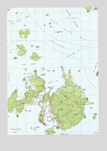
Swans Island, ME USGS Topographic Map
Click on map above to begin viewing in our Map Viewer.

This topographic map contains these locations and features:
Feature Name Type Latitude Longitude GNIS ID View Map
Asa IslandIslandN44.1901°W68.4522°579995View Map
AtlanticPopulated PlaceN44.1717°W68.4242°561339View Map
Atlantic CemeteryCemeteryN44.1805°W68.4166°2736617View Map
Back CoveBayN44.1665°W68.4495°561403View Map
Banks AirportAirportN44.1658°W68.4302°582235View Map
Big MountainSummitN44.1499°W68.4240°562211View Map
Black IslandIslandN44.2009°W68.4603°562444View Map
Blue Hill Bay LighthouseLocaleN44.2487°W68.4981°562595View Map
Buckle IslandIslandN44.1795°W68.4764°563116View Map
Buckle Island HarborBayN44.1773°W68.4717°579951View Map
Burnt Coat HarborBayN44.1420°W68.4453°563270View Map
Burnt PointCapeN44.1870°W68.4145°580575View Map
Casco PassageChannelN44.1940°W68.4686°563662View Map
Channel RockIslandN44.2451°W68.4878°563842View Map
City PointCapeN44.1531°W68.4453°580587View Map
Crow IslandIslandN44.1879°W68.4381°564603View Map
Dog IslandIslandN44.1381°W68.4389°580589View Map
Duck IslandIslandN44.1756°W68.4745°565340View Map
Eagle IslandIslandN44.2115°W68.4589°565490View Map
East BargeIslandN44.2309°W68.4409°565517View Map
East PointCapeN44.1559°W68.3864°565664View Map
Fir PointCapeN44.1829°W68.4236°566158View Map
Flye Island LedgeBarN44.2437°W68.4989°580570View Map
Garden CoveBayN44.1820°W68.4620°1911627View Map
Garden IslandsIslandN44.1829°W68.4600°579970View Map
Goose PondLakeN44.1474°W68.4169°566927View Map
Goose Pond MountainSummitN44.1445°W68.4092°566933View Map
Gooseberry IslandIslandN44.1329°W68.4628°566952View Map
Gooseberry Island LedgeBarN44.1304°W68.4603°580591View Map
Green IslandIslandN44.2487°W68.4984°567219View Map
Grindle Hill CemeteryCemeteryN44.1570°W68.4514°2736645View Map
Harbor IslandIslandN44.1276°W68.4403°567592View Map
Hawley LedgeBarN44.1862°W68.4753°580573View Map
Hen IslandIslandN44.1712°W68.4736°567932View Map
Hero BeachBeachN44.1342°W68.4114°580593View Map
High HeadCliffN44.1601°W68.3900°580578View Map
High SheriffBarN44.1323°W68.4684°568027View Map
Hockamock HeadCapeN44.1362°W68.4500°568127View Map
Hockamock Head CemeteryCemeteryN44.1367°W68.4511°2736657View Map
Hockamock Head LighthouseBuildingN44.1342°W68.4470°1911688View Map
Irish PointCapeN44.1442°W68.4864°568671View Map
Irish Point CemeteryCemeteryN44.1576°W68.4886°2736660View Map
Johns IslandIslandN44.2006°W68.4881°568897View Map
Johnstons IslandIslandN44.1384°W68.4411°580584View Map
Joyce BeachBeachN44.1701°W68.4009°569012View Map
Lamp IslandIslandN44.2323°W68.4767°569352View Map
Lily PondSwampN44.1501°W68.4336°569585View Map
Little House CoveBayN44.1573°W68.4645°580579View Map
Long CoveBayN44.1359°W68.4339°570191View Map
Long LedgeBarN44.1895°W68.4772°580572View Map
Mackerel CoveBayN44.1784°W68.4367°570629View Map
MinturnPopulated PlaceN44.1426°W68.4364°579989View Map
North CemeteryCemeteryN44.1682°W68.4629°2736682View Map
North PointCapeN44.1898°W68.4245°572383View Map
Nutter PointCapeN44.2467°W68.3886°581472View Map
Opechee IslandIslandN44.2076°W68.4803°572750View Map
Orono IslandIslandN44.1865°W68.4611°572774View Map
Otter PondsLakeN44.1532°W68.3970°572854View Map
Parks IslandIslandN44.1431°W68.4453°580586View Map
Phinney PointCapeN44.1690°W68.3967°580577View Map
Pond IslandIslandN44.2245°W68.4770°573600View Map
Pond Island PassageChannelN44.2387°W68.4825°580569View Map
Quarry PondLakeN44.1399°W68.4330°1911875View Map
Ram IslandIslandN44.1512°W68.3867°573998View Map
Red PointCapeN44.1426°W68.3945°574091View Map
RichtownPopulated PlaceN44.2473°W68.3772°1911881View Map
Richtown CemeteryCemeteryN44.2487°W68.3762°2736322View Map
Roderick HeadCapeN44.1706°W68.4397°574415View Map
Round IslandIslandN44.1837°W68.4500°574472View Map
Sand BeachBeachN44.1556°W68.4759°580580View Map
Sand Beach LedgeIslandN44.1484°W68.4717°1911903View Map
Sand CoveBayN44.1540°W68.4734°580583View Map
Sea CoveBayN44.1645°W68.4809°580000View Map
Sheep IslandIslandN44.2129°W68.4681°575343View Map
Sheriff LedgeBarN44.1290°W68.4650°580590View Map
Ship and Barges LedgeBarN44.2262°W68.4320°580571View Map
Ship IslandIslandN44.2342°W68.4403°575413View Map
Sister IslandsIslandN44.1431°W68.3814°581621View Map
Sister LedgeBarN44.1392°W68.3839°580588View Map
Southwest CoveBayN44.1259°W68.4453°580594View Map
Stanley PointCapeN44.1320°W68.4309°576244View Map
Staple LedgeBarN44.1876°W68.3995°580576View Map
Stockbridge CemeteryCemeteryN44.1604°W68.4208°2736336View Map
Stockbridge HillSummitN44.1623°W68.4224°576365View Map
Stockbridge PondLakeN44.1579°W68.4237°576367View Map
Stony IslandIslandN44.1429°W68.4434°580585View Map
Swan's Island Post OfficePost OfficeN44.1545°W68.4515°1912002View Map
Swans IslandPopulated PlaceN44.1451°W68.4517°581497View Map
Swans IslandIslandN44.1584°W68.4295°576587View Map
Swans Island Education SocietyBuildingN44.1717°W68.4245°1911998View Map
Swans Island Elementary SchoolSchoolN44.1824°W68.4174°1911999View Map
Swans Island Fire DepartmentBuildingN44.1747°W68.4162°2553207View Map
Swans Island HeadCapeN44.1681°W68.4884°581620View Map
Swans Island Police DepartmentBuildingN44.1545°W68.4515°2735824View Map
Swans Island Public LibraryBuildingN44.1711°W68.4121°1912000View Map
Swans Island Volunteer Ambulance ServiceBuildingN44.1746°W68.4162°2666804View Map
Swans Island Volunteer Fire DepartmentBuildingN44.1463°W68.4511°2553119View Map
The HubsIslandN44.1334°W68.4350°580592View Map
The TrianglesBarN44.1876°W68.4456°576938View Map
Toothacher BayBayN44.1334°W68.4920°576926View Map
Toothacher CoveBayN44.1576°W68.4600°577193View Map
Town of Swans IslandCivilN44.1266°W68.4471°582757View Map
Trumpet IslandIslandN44.2429°W68.4425°577376View Map
West BargeIslandN44.2326°W68.4495°578021View Map
West Sister IslandIslandN44.1420°W68.3814°578227View Map
Whale CoveBayN44.1509°W68.4792°580581View Map
Whale LedgeBarN44.1490°W68.4770°580582View Map
York NarrowsChannelN44.1848°W68.4739°580574View Map

Note: Coordinates in the location and feature list above are referenced to NAD83 datum.


Copyright (C) 2008-2024 Ryan Niemi / Sunset Dynamics ... All Rights Reserved