TopoQuest Logo
Do you find TopoQuest useful?
Help keep TopoQuest running and adding new maps/features by donating!
Bitcoin:  19c7KJd3qBynnjoSw5npx9KScwjBe4ifkT
Litecoin:  LXs6TkuXGGXo1vDsWCkWVdjQX94eUKd6ui
Home View Maps Find Maps Find Places Resources & Links


Literberry, Illinois Topographic Map

USGS Map Title: Literberry, IL
USGS Map MRC: 39090G2
DRG (GeoTIFF) Download: o39090g2.tif


Neighboring USGS Topographic Map Quads:


  Arenzville East, IL  
39090H3
 

  Virginia, IL  
39090H2
 

  Ashland, IL  
39090H1
 

  Concord, IL  
39090G3
 

  Literberry, IL  
39090G2
 

  Prentice, IL  
39090G1
 

  Lynnville, IL  
39090F3
 

  Jacksonville, IL  
39090F2
 

  Alexander, IL  
39090F1


Map MRC Location:

N40°
W91°
N40°
W90°
H8 H7 H6 H5 H4 H3 H2 H1
G8 G7 G6 G5 G4 G3 G2 G1
F8 F7 F6 F5 F4 F3 F2 F1
E8 E7 E6 E5 E4 E3 E2 E1
D8 D7 D6 D5 D4 D3 D2 D1
C8 C7 C6 C5 C4 C3 C2 C1
B8 B7 B6 B5 B4 B3 B2 B1
A8 A7 A6 A5 A4 A3 A2 A1
N39°
W91°
N39°
W90°

Literberry, IL USGS 1:24K Topographic Map Preview:
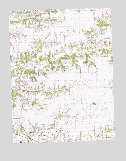
Literberry, IL USGS Topographic Map
Click on map above to begin viewing in our Map Viewer.

This topographic map contains these locations and features:
Feature Name Type Latitude Longitude GNIS ID View Map
ArcadiaPopulated PlaceN39.8392°W90.2448°403589View Map
Arcadia CemeteryCemeteryN39.8437°W90.2493°1822095View Map
Arcadia ChurchChurchN39.8425°W90.2482°1720908View Map
Brownton (historical)Populated PlaceN39.7637°W90.1912°422506View Map
Brush College School (historical)SchoolN39.8667°W90.2357°405018View Map
Cavanaugh BluffCliffN39.8339°W90.1254°405716View Map
Clark Chapel (historical)ChurchN39.7795°W90.1832°406158View Map
Conover BranchStreamN39.8375°W90.1460°406483View Map
Crazy Horse CampgroundLocaleN39.8284°W90.1801°1720915View Map
Fretag LakeReservoirN39.8111°W90.2268°1692375View Map
Fretag Lake DamDamN39.8134°W90.2268°1692374View Map
Hazel Green CemeteryCemeteryN39.7814°W90.2146°1720921View Map
Henderson-McFadden CemeteryCemeteryN39.8478°W90.2382°1720925View Map
Hickory Grove School (historical)SchoolN39.7667°W90.1976°410158View Map
Independence School (historical)SchoolN39.8078°W90.1773°410818View Map
Jacksonville High SchoolSchoolN39.7506°W90.2398°1720928View Map
Jacksonville Municipal AirportAirportN39.7711°W90.2378°427397View Map
Liter CemeteryCemeteryN39.8637°W90.1871°1720931View Map
LiterberryPopulated PlaceN39.8542°W90.1996°412269View Map
Literberry Election PrecinctCivilN39.8038°W90.1786°1928558View Map
Literberry Post OfficePost OfficeN39.8528°W90.2007°1822119View Map
Little Indian CreekStreamN39.8353°W90.1257°412358View Map
Mauvaise Terre School (historical)SchoolN39.7581°W90.1259°413139View Map
North Jacksonville SchoolSchoolN39.7598°W90.2282°1720938View Map
North Oakland School (historical)SchoolN39.8073°W90.2121°414633View Map
Oak Ridge CemeteryCemeteryN39.8464°W90.1326°1720939View Map
Oak Ridge School (historical)SchoolN39.8487°W90.1451°414854View Map
Phillips CemeteryCemeteryN39.8023°W90.1862°1822127View Map
Portuguese HillPopulated PlaceN39.7559°W90.2154°416052View Map
Prairie Union School (historical)SchoolN39.7673°W90.1637°416170View Map
Rucker CemeteryCemeteryN39.8423°W90.1927°1720942View Map
Sample CemeteryCemeteryN39.7610°W90.1928°1720943View Map
Savage (historical)Populated PlaceN39.7814°W90.2110°423160View Map
Sherman School (historical)SchoolN39.7750°W90.2293°418371View Map
Snake CreekStreamN39.8200°W90.2323°418667View Map
Strawns CrossingPopulated PlaceN39.7859°W90.1510°423213View Map
Trinidad School (historical)SchoolN39.7603°W90.2073°419848View Map
Union Grove School (historical)SchoolN39.8170°W90.1460°420082View Map
Valevue LakeReservoirN39.8000°W90.2251°1692377View Map
Valevue Lake DamDamN39.8000°W90.2251°1692376View Map

Note: Coordinates in the location and feature list above are referenced to NAD83 datum.


Copyright (C) 2008-2024 Ryan Niemi / Sunset Dynamics ... All Rights Reserved