TopoQuest Logo
Do you find TopoQuest useful?
Help keep TopoQuest running and adding new maps/features by donating!
Bitcoin:  19c7KJd3qBynnjoSw5npx9KScwjBe4ifkT
Litecoin:  LXs6TkuXGGXo1vDsWCkWVdjQX94eUKd6ui
Home View Maps Find Maps Find Places Resources & Links


Liverpool, Texas Topographic Map

USGS Map Title: Liverpool, TX
USGS Map MRC: 29095C3
DRG (GeoTIFF) Download: o29095c3.tif


Neighboring USGS Topographic Map Quads:


  Juliff, TX  
29095D4
 

  Manvel, TX  
29095D3
 

  Algoa, TX  
29095D2
 

  Rosharon, TX  
29095C4
 

  Liverpool, TX  
29095C3
 

  Mustang Bayou, TX  
29095C2
 

  Angleton, TX  
29095B4
 

  Danbury, TX  
29095B3
 

  Hoskins Mound, TX  
29095B2


Map MRC Location:

N30°
W96°
N30°
W95°
H8 H7 H6 H5 H4 H3 H2 H1
G8 G7 G6 G5 G4 G3 G2 G1
F8 F7 F6 F5 F4 F3 F2 F1
E8 E7 E6 E5 E4 E3 E2 E1
D8 D7 D6 D5 D4 D3 D2 D1
C8 C7 C6 C5 C4 C3 C2 C1
B8 B7 B6 B5 B4 B3 B2 B1
A8 A7 A6 A5 A4 A3 A2 A1
N29°
W96°
N29°
W95°

Liverpool, TX USGS 1:24K Topographic Map Preview:
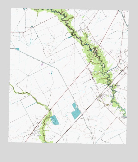
Liverpool, TX USGS Topographic Map
Click on map above to begin viewing in our Map Viewer.

This topographic map contains these locations and features:
Feature Name Type Latitude Longitude GNIS ID View Map
Alvin-Pearland DivisionCivilN29.3478°W95.2724°1938486View Map
Bell LateralCanalN29.3433°W95.3616°1351839View Map
Camp MohawkLocaleN29.3375°W95.2908°1353652View Map
Chocolate BayouPopulated PlaceN29.3152°W95.2538°1354458View Map
Chocolate SpringsPopulated PlaceN29.3047°W95.2622°1379546View Map
City of LiverpoolCivilN29.2987°W95.2720°2410849View Map
Corner BayouStreamN29.2891°W95.2658°1355005View Map
Dingle Lake Number 1ReservoirN29.2796°W95.3045°1857724View Map
Dingle Lake Number 1 LeveeDamN29.2802°W95.3002°1857723View Map
Dingle Lake Number 2ReservoirN29.2856°W95.3058°1857726View Map
Dingle Lake Number 2 LeveeDamN29.2852°W95.3035°1857725View Map
Garrett DamDamN29.2686°W95.3269°1857727View Map
Garrett LakeReservoirN29.2685°W95.3276°1857728View Map
Garrett LakesLakeN29.2699°W95.3247°1357905View Map
Garrett Ranch AirportAirportN29.2912°W95.3620°1386504View Map
J-D Ranch AirportAirportN29.3728°W95.2891°1386143View Map
LiverpoolPopulated PlaceN29.2950°W95.2788°1361569View Map
Liverpool CemeteryCemeteryN29.2952°W95.2655°1361570View Map
Liverpool Police DepartmentBuildingN29.2959°W95.2771°2375811View Map
Liverpool Post OfficePost OfficeN29.2940°W95.2786°2731615View Map
Liverpool Volunteer Fire DepartmentBuildingN29.2957°W95.2776°2334337View Map
Minard Pegasus AirportAirportN29.3350°W95.2731°2675945View Map
Pearland Branch LibraryBuildingN29.2697°W95.2560°2014784View Map
Rowan Oil FieldOilfieldN29.3486°W95.2902°1366980View Map
Songbird Ranch AirportAirportN29.3686°W95.3399°1387428View Map
South Texas Water Company CanalCanalN29.3211°W95.3280°1368786View Map
Toy AirparkAirportN29.3327°W95.3341°2675768View Map

Note: Coordinates in the location and feature list above are referenced to NAD83 datum.


Copyright (C) 2008-2025 Ryan Niemi / Sunset Dynamics ... All Rights Reserved