TopoQuest Logo
Do you find TopoQuest useful?
Help keep TopoQuest running and adding new maps/features by donating!
Bitcoin:  19c7KJd3qBynnjoSw5npx9KScwjBe4ifkT
Litecoin:  LXs6TkuXGGXo1vDsWCkWVdjQX94eUKd6ui
Home View Maps Find Maps Find Places Resources & Links


Rosharon, Texas Topographic Map

USGS Map Title: Rosharon, TX
USGS Map MRC: 29095C4
DRG (GeoTIFF) Download: o29095c4.tif


Neighboring USGS Topographic Map Quads:


  Thompsons, TX  
29095D5
 

  Juliff, TX  
29095D4
 

  Manvel, TX  
29095D3
 

  Otey, TX  
29095C5
 

  Rosharon, TX  
29095C4
 

  Liverpool, TX  
29095C3
 

  East Columbia, TX  
29095B5
 

  Angleton, TX  
29095B4
 

  Danbury, TX  
29095B3


Map MRC Location:

N30°
W96°
N30°
W95°
H8 H7 H6 H5 H4 H3 H2 H1
G8 G7 G6 G5 G4 G3 G2 G1
F8 F7 F6 F5 F4 F3 F2 F1
E8 E7 E6 E5 E4 E3 E2 E1
D8 D7 D6 D5 D4 D3 D2 D1
C8 C7 C6 C5 C4 C3 C2 C1
B8 B7 B6 B5 B4 B3 B2 B1
A8 A7 A6 A5 A4 A3 A2 A1
N29°
W96°
N29°
W95°

Rosharon, TX USGS 1:24K Topographic Map Preview:
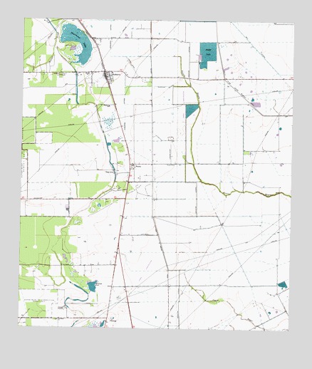
Rosharon, TX USGS Topographic Map
Click on map above to begin viewing in our Map Viewer.

This topographic map contains these locations and features:
Feature Name Type Latitude Longitude GNIS ID View Map
Archer LakeReservoirN29.3622°W95.4151°1857732View Map
Archer Lake LeveeDamN29.3586°W95.4186°1857731View Map
BB AirparkAirportN29.3569°W95.4594°2675967View Map
Bonner SloughLakeN29.3704°W95.4856°1372674View Map
BonneyPopulated PlaceN29.3166°W95.4480°1379443View Map
Bonney Oil FieldOilfieldN29.3080°W95.4469°1352668View Map
ChenangoPopulated PlaceN29.2541°W95.4588°1379536View Map
Chenango PlantationLocaleN29.2586°W95.4786°1354340View Map
Chenango PondLakeN29.2670°W95.4665°1354341View Map
China GrovePopulated PlaceN29.3127°W95.4566°1379540View Map
City of AlvinCivilN29.3408°W95.4518°2409692View Map
Daughters CemeteryCemeteryN29.3525°W95.4830°1355661View Map
Division LakeReservoirN29.3393°W95.4224°1857730View Map
Division Lake LeveeDamN29.3402°W95.4186°1857729View Map
Ellon ChurchChurchN29.3533°W95.4699°1356936View Map
Flyin Tiger AirportAirportN29.2650°W95.4119°1386159View Map
Pilgrim CemeteryCemeteryN29.3525°W95.4822°1365220View Map
Providence ChurchChurchN29.2536°W95.4822°1365816View Map
Riceland Flying Service Airport (historical)AirportN29.3502°W95.4502°1387426View Map
RosharonPopulated PlaceN29.3522°W95.4602°1366883View Map
Rosharon Census Designated PlaceCensusN29.3500°W95.4531°2586981View Map
Rosharon LateralCanalN29.3739°W95.4599°1375823View Map
Rosharon LateralCanalN29.3375°W95.4527°1366884View Map
Rosharon Post OfficePost OfficeN29.3514°W95.4364°2732182View Map
Rosharon SchoolSchoolN29.3400°W95.4599°1366885View Map
Rosharon Volunteer Fire DepartmentBuildingN29.3501°W95.4604°2334495View Map
Thurmond LakeLakeN29.3687°W95.4780°1369915View Map
Village of BonneyCivilN29.3023°W95.4516°2413533View Map
Village of Bonney City HallBuildingN29.3155°W95.4496°2753364View Map

Note: Coordinates in the location and feature list above are referenced to NAD83 datum.


Copyright (C) 2008-2025 Ryan Niemi / Sunset Dynamics ... All Rights Reserved