TopoQuest Logo
Do you find TopoQuest useful?
Help keep TopoQuest running and adding new maps/features by donating!
Bitcoin:  19c7KJd3qBynnjoSw5npx9KScwjBe4ifkT
Litecoin:  LXs6TkuXGGXo1vDsWCkWVdjQX94eUKd6ui
Home View Maps Find Maps Find Places Resources & Links


Livingston, Texas Topographic Map

USGS Map Title: Livingston, TX
USGS Map MRC: 30094F8
DRG (GeoTIFF) Download: o30094f8.tif


Neighboring USGS Topographic Map Quads:


  Onalaska, TX  
30095G1
 

  New Willard, TX  
30094G8
 

  Leggett, TX  
30094G7
 

  Blanchard, TX  
30095F1
 

  Livingston, TX  
30094F8
 

  Soda, TX  
30094F7
 

  Camilla, TX  
30095E1
 

  Goodrich, TX  
30094E8
 

  Schwab City, TX  
30094E7


Map MRC Location:

N31°
W95°
N31°
W94°
H8 H7 H6 H5 H4 H3 H2 H1
G8 G7 G6 G5 G4 G3 G2 G1
F8 F7 F6 F5 F4 F3 F2 F1
E8 E7 E6 E5 E4 E3 E2 E1
D8 D7 D6 D5 D4 D3 D2 D1
C8 C7 C6 C5 C4 C3 C2 C1
B8 B7 B6 B5 B4 B3 B2 B1
A8 A7 A6 A5 A4 A3 A2 A1
N30°
W95°
N30°
W94°

Livingston, TX USGS 1:24K Topographic Map Preview:
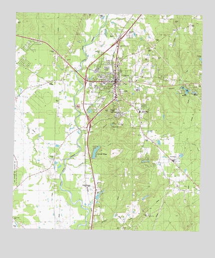
Livingston, TX USGS Topographic Map
Click on map above to begin viewing in our Map Viewer.

This topographic map contains these locations and features:
Feature Name Type Latitude Longitude GNIS ID View Map
Camp Cho YenLocaleN30.6894°W94.9344°1353614View Map
Camp Cho-YehLocaleN30.6861°W94.9347°2573494View Map
Choates CreekStreamN30.6916°W94.9563°1354457View Map
Churton Corporation DamDamN30.7252°W94.8802°1854294View Map
Crooked CreekStreamN30.6630°W94.9655°1355380View Map
Crystal Lakes Country EstatesPopulated PlaceN30.7083°W94.8750°2573490View Map
Dogwood LakeReservoirN30.7252°W94.8802°1854295View Map
East TempePopulated PlaceN30.7035°W94.9849°2034985View Map
East Tempe ChurchChurchN30.7102°W94.9766°1356722View Map
Forest Hill CemeteryCemeteryN30.6938°W94.9316°1357561View Map
Henderson LakeReservoirN30.6444°W94.9435°1854320View Map
Henderson Lake DamDamN30.6435°W94.9452°1854319View Map
IsraelPopulated PlaceN30.7424°W94.8919°2034835View Map
KETX-AM (Livingston)TowerN30.7399°W94.9252°1385616View Map
KETX-FM (Livingston)TowerN30.7399°W94.9252°1385911View Map
Lake JobeReservoirN30.7083°W94.8887°1862583View Map
Lake Jobe DamDamN30.7085°W94.8902°1862582View Map
Lake ThunderbirdReservoirN30.6938°W94.9498°1863592View Map
Lake Thunderbird DamDamN30.6935°W94.9502°1863591View Map
Lakeside Village Estates LakeReservoirN30.6699°W94.9458°1854291View Map
Lakeside Village Estates Lake DamDamN30.6669°W94.9469°1854290View Map
LamontPopulated PlaceN30.6574°W94.9519°1380054View Map
Lima BranchStreamN30.6821°W94.9555°1361198View Map
LivingstonPopulated PlaceN30.7110°W94.9330°1361573View Map
Livingston City HallBuildingN30.7115°W94.9347°2753558View Map
Livingston City ParkParkN30.6996°W94.9422°2028960View Map
Livingston Elementary SchoolSchoolN30.7144°W94.9422°2008086View Map
Livingston Intermediate SchoolSchoolN30.7099°W94.9391°2008088View Map
Livingston Junior High SchoolSchoolN30.7110°W94.9402°2008089View Map
Livingston LookoutLocaleN30.7388°W94.8980°1361574View Map
Livingston Police DepartmentBuildingN30.7115°W94.9347°2751243View Map
Livingston Post OfficePost OfficeN30.7104°W94.9482°2732065View Map
Livingston Volunteer Fire Department Station 1BuildingN30.7092°W94.9334°2655189View Map
Livingston Volunteer Fire Department Station 2BuildingN30.7153°W94.9345°2655424View Map
Livingston Volunteer Fire Department Station 3BuildingN30.6907°W94.9161°2655425View Map
Lone Star Emergency Medical ServiceBuildingN30.7462°W94.9206°2720987View Map
Memorial Medical CenterHospitalN30.7311°W94.9392°2015744View Map
Morgan CreekStreamN30.6274°W94.9510°1363142View Map
Mount Rose ChurchChurchN30.6660°W94.9727°1363318View Map
Peebles CemeteryCemeteryN30.6349°W94.9099°1365013View Map
Polk County Constable's Office Precinct 1BuildingN30.7106°W94.9335°2751356View Map
Polk County Constable's Office Precinct 4BuildingN30.7232°W94.9337°2751520View Map
Polk County CourthouseBuildingN30.7113°W94.9335°2030570View Map
Polk County JailBuildingN30.7233°W94.9337°2738742View Map
Polk County MuseumBuildingN30.7110°W94.9347°2014529View Map
Polk County Sheriff's OfficeBuildingN30.7233°W94.9338°2751123View Map
ProvidencePopulated PlaceN30.6655°W94.8938°1365811View Map
Restland Memorial CemeteryCemeteryN30.6499°W94.9466°1366382View Map
Tempe CreekStreamN30.6541°W94.9694°1376412View Map
Texas Forest Service Livingston OfficeBuildingN30.7106°W94.8800°2655472View Map
Town of LivingstonCivilN30.7100°W94.9381°2412903View Map

Note: Coordinates in the location and feature list above are referenced to NAD83 datum.


Copyright (C) 2008-2025 Ryan Niemi / Sunset Dynamics ... All Rights Reserved