TopoQuest Logo
Do you find TopoQuest useful?
Help keep TopoQuest running and adding new maps/features by donating!
Bitcoin:  19c7KJd3qBynnjoSw5npx9KScwjBe4ifkT
Litecoin:  LXs6TkuXGGXo1vDsWCkWVdjQX94eUKd6ui
Home View Maps Find Maps Find Places Resources & Links


Blanchard, Texas Topographic Map

USGS Map Title: Blanchard, TX
USGS Map MRC: 30095F1
DRG (GeoTIFF) Download: o30095f1.tif


Neighboring USGS Topographic Map Quads:


  Carlisle, TX  
30095G2
 

  Onalaska, TX  
30095G1
 

  New Willard, TX  
30094G8
 

  Stephen Creek, TX  
30095F2
 

  Blanchard, TX  
30095F1
 

  Livingston, TX  
30094F8
 

  Coldspring, TX  
30095E2
 

  Camilla, TX  
30095E1
 

  Goodrich, TX  
30094E8


Map MRC Location:

N31°
W96°
N31°
W95°
H8 H7 H6 H5 H4 H3 H2 H1
G8 G7 G6 G5 G4 G3 G2 G1
F8 F7 F6 F5 F4 F3 F2 F1
E8 E7 E6 E5 E4 E3 E2 E1
D8 D7 D6 D5 D4 D3 D2 D1
C8 C7 C6 C5 C4 C3 C2 C1
B8 B7 B6 B5 B4 B3 B2 B1
A8 A7 A6 A5 A4 A3 A2 A1
N30°
W96°
N30°
W95°

Blanchard, TX USGS 1:24K Topographic Map Preview:
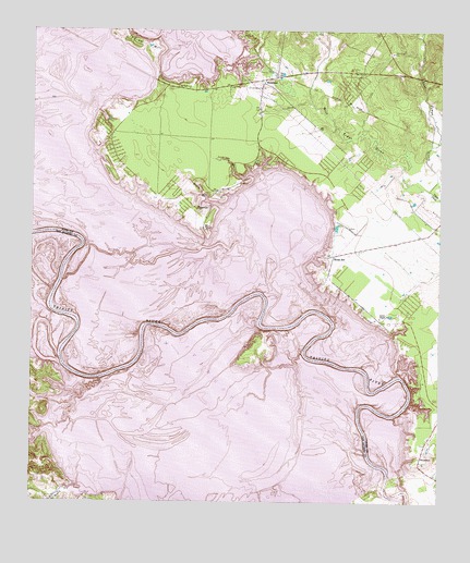
Blanchard, TX USGS Topographic Map
Click on map above to begin viewing in our Map Viewer.

This topographic map contains these locations and features:
Feature Name Type Latitude Longitude GNIS ID View Map
Black BranchStreamN30.7035°W95.0663°1372594View Map
BlanchardPopulated PlaceN30.7369°W95.0555°1380822View Map
East Tempe CreekStreamN30.7080°W95.0033°1373569View Map
Garner ChapelChurchN30.6741°W95.0180°1373813View Map
Indian BranchStreamN30.7424°W95.0633°1374196View Map
Indian CreekStreamN30.6574°W95.1035°1383112View Map
Indian HillSummitN30.7463°W95.0916°1374218View Map
Jennings BranchStreamN30.7127°W95.0569°1374281View Map
Lake Livingston State ParkParkN30.6638°W95.0022°2028981View Map
Lake Livingston State Park TrailTrailN30.6655°W95.0066°2033490View Map
Livingston DamDamN30.6335°W95.0152°1861777View Map
Livingston Municipal AirportAirportN30.6859°W95.0179°1387089View Map
Moore HillPopulated PlaceN30.6905°W95.0322°1380886View Map
Rocky CreekStreamN30.6294°W95.1108°1383167View Map
Scenic Loop Volunteer Fire DepartmentBuildingN30.7236°W95.1006°2655427View Map
SwartoutPopulated PlaceN30.6385°W95.0049°1380932View Map
Texas Department of Criminal Justice Allan B Polunsky UnitBuildingN30.6985°W95.0147°2738558View Map
TigervillePopulated PlaceN30.7027°W95.0738°1380934View Map
Tobacco PatchPopulated PlaceN30.7232°W95.1041°2034995View Map
West LivingstonPopulated PlaceN30.6983°W95.0019°1852781View Map
West Livingston Census Designated PlaceCensusN30.6957°W95.0097°2409553View Map
West Tempe CreekStreamN30.7080°W95.0033°1376727View Map

Note: Coordinates in the location and feature list above are referenced to NAD83 datum.


Copyright (C) 2008-2025 Ryan Niemi / Sunset Dynamics ... All Rights Reserved