TopoQuest Logo
Do you find TopoQuest useful?
Help keep TopoQuest running and adding new maps/features by donating!
Bitcoin:  19c7KJd3qBynnjoSw5npx9KScwjBe4ifkT
Litecoin:  LXs6TkuXGGXo1vDsWCkWVdjQX94eUKd6ui
Home View Maps Find Maps Find Places Resources & Links


Livingston Creek, Idaho Topographic Map

USGS Map Title: Livingston Creek, ID
USGS Map MRC: 44114B5
DRG (GeoTIFF) Download: o44114b5.tif


Neighboring USGS Topographic Map Quads:


  Sunbeam, ID  
44114C6
 

  Thompson Creek, ID  
44114C5
 

  Clayton, ID  
44114C4
 

  Robinson Bar, ID  
44114B6
 

  Livingston Creek, ID  
44114B5
 

  Potaman Peak, ID  
44114B4
 

  Washington Peak, ID  
44114A6
 

  Boulder Chain Lakes, ID  
44114A5
 

  Bowery Creek, ID  
44114A4


Map MRC Location:

N45°
W115°
N45°
W114°
H8 H7 H6 H5 H4 H3 H2 H1
G8 G7 G6 G5 G4 G3 G2 G1
F8 F7 F6 F5 F4 F3 F2 F1
E8 E7 E6 E5 E4 E3 E2 E1
D8 D7 D6 D5 D4 D3 D2 D1
C8 C7 C6 C5 C4 C3 C2 C1
B8 B7 B6 B5 B4 B3 B2 B1
A8 A7 A6 A5 A4 A3 A2 A1
N44°
W115°
N44°
W114°

Livingston Creek, ID USGS 1:24K Topographic Map Preview:
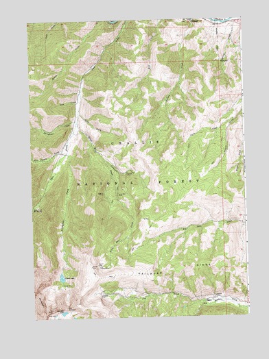
Livingston Creek, ID USGS Topographic Map
Click on map above to begin viewing in our Map Viewer.

This topographic map contains these locations and features:
Feature Name Type Latitude Longitude GNIS ID View Map
Cal-Ida MineMineN44.1855°W114.5695°378691View Map
Carbonate CreekStreamN44.1916°W114.5820°378903View Map
Chinese WallCliffN44.1285°W114.6192°379309View Map
Coal Camp ForkStreamN44.2074°W114.5059°379464View Map
Crater LakeLakeN44.1420°W114.6085°380043View Map
Crater MineMineN44.1391°W114.6078°380048View Map
Dike LakeLakeN44.1262°W114.6124°380592View Map
Gunsight LakeLakeN44.1272°W114.6076°382777View Map
Hermit MineMineN44.1471°W114.5876°383118View Map
Holman CreekStreamN44.2496°W114.5298°383261View Map
Holman Creek CampgroundLocaleN44.2491°W114.5298°383262View Map
Hoodoo Mine Number One DamDamN44.1682°W114.6242°398889View Map
Jim CreekStreamN44.1310°W114.5181°383910View Map
Last Chance CreekStreamN44.1991°W114.6031°384452View Map
Little Livingston MineMineN44.1463°W114.5873°384879View Map
Livingston CreekStreamN44.1946°W114.6040°385006View Map
Livingston MillLocaleN44.1327°W114.5198°396810View Map
Livingston MineMineN44.1352°W114.5865°385007View Map
Railroad RidgeRidgeN44.1402°W114.5573°389033View Map
Sheephead CreekStreamN44.2082°W114.5970°390269View Map
Silver Rule CreekStreamN44.2074°W114.5978°390454View Map
Silver Rute MineMineN44.1769°W114.5748°375033View Map
Sink CreekStreamN44.2052°W114.6045°390477View Map
Sled CreekStreamN44.2138°W114.6034°390588View Map
Spring CreekStreamN44.2471°W114.5056°391169View Map
Tango MineMineN44.1771°W114.5840°391842View Map
The GunsightGapN44.1291°W114.6065°391964View Map
Thompson CreekStreamN44.2491°W114.5173°392032View Map

Note: Coordinates in the location and feature list above are referenced to NAD83 datum.


Copyright (C) 2008-2025 Ryan Niemi / Sunset Dynamics ... All Rights Reserved