TopoQuest Logo
Do you find TopoQuest useful?
Help keep TopoQuest running and adding new maps/features by donating!
Bitcoin:  19c7KJd3qBynnjoSw5npx9KScwjBe4ifkT
Litecoin:  LXs6TkuXGGXo1vDsWCkWVdjQX94eUKd6ui
Home View Maps Find Maps Find Places Resources & Links


Loami, Illinois Topographic Map

USGS Map Title: Loami, IL
USGS Map MRC: 39089F7
DRG (GeoTIFF) Download: o39089f7.tif


Neighboring USGS Topographic Map Quads:


  Pleasant Plains, IL  
39089G8
 

  Farmingdale, IL  
39089G7
 

  Springfield West, IL  
39089G6
 

  New Berlin, IL  
39089F8
 

  Loami, IL  
39089F7
 

  Chatham, IL  
39089F6
 

  Waverly, IL  
39089E8
 

  Virden North, IL  
39089E7
 

  Divernon, IL  
39089E6


Map MRC Location:

N40°
W90°
N40°
W89°
H8 H7 H6 H5 H4 H3 H2 H1
G8 G7 G6 G5 G4 G3 G2 G1
F8 F7 F6 F5 F4 F3 F2 F1
E8 E7 E6 E5 E4 E3 E2 E1
D8 D7 D6 D5 D4 D3 D2 D1
C8 C7 C6 C5 C4 C3 C2 C1
B8 B7 B6 B5 B4 B3 B2 B1
A8 A7 A6 A5 A4 A3 A2 A1
N39°
W90°
N39°
W89°

Loami, IL USGS 1:24K Topographic Map Preview:
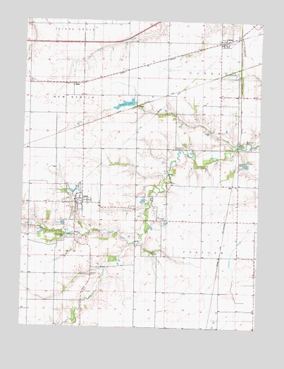
Loami, IL USGS Topographic Map
Click on map above to begin viewing in our Map Viewer.

This topographic map contains these locations and features:
Feature Name Type Latitude Longitude GNIS ID View Map
Allen School (historical)SchoolN39.7476°W89.8546°403427View Map
BatesPopulated PlaceN39.7242°W89.8495°422441View Map
Campbell CemeteryCemeteryN39.6464°W89.8384°1736854View Map
College Corner School (historical)SchoolN39.7123°W89.7620°406366View Map
CurranPopulated PlaceN39.7423°W89.7720°406902View Map
Fairplay School (historical)SchoolN39.6256°W89.8001°408185View Map
Highwater Mark School (historical)SchoolN39.6539°W89.8704°410245View Map
Hong Kong School (historical)SchoolN39.6495°W89.8376°410486View Map
John Campbell CemeteryCemeteryN39.6696°W89.7994°1736855View Map
Johns CreekStreamN39.6251°W89.8509°411140View Map
KnappPopulated PlaceN39.7148°W89.8168°422885View Map
Lake LoamiReservoirN39.6673°W89.8533°2071859View Map
Leisure LakesReservoirN39.6917°W89.7573°1736873View Map
LoamiPopulated PlaceN39.6756°W89.8468°412461View Map
Loami Christian ChurchChurchN39.6753°W89.8434°2043692View Map
Loami Elementary SchoolSchoolN39.6745°W89.8434°1821089View Map
Loami Fire DepartmentBuildingN39.6748°W89.8470°2640209View Map
Loami Post OfficePost OfficeN39.6749°W89.8466°2788668View Map
Loami United Methodist ChurchChurchN39.6739°W89.8459°2043693View Map
McGinnis CemeteryCemeteryN39.6987°W89.7945°1736878View Map
Mound Grove School (historical)SchoolN39.7131°W89.7943°413909View Map
Oak Grove CemeteryCemeteryN39.6562°W89.8026°1736888View Map
Oak Grove School (historical)SchoolN39.6542°W89.8026°414803View Map
Oak Ridge School (historical)SchoolN39.6917°W89.7607°414853View Map
Patterson CemeteryCemeteryN39.7163°W89.7809°1821095View Map
Patton School (historical)SchoolN39.7120°W89.8726°415453View Map
Pleasant View School (historical)SchoolN39.6551°W89.7587°415929View Map
Reyhan HeliportAirportN39.6776°W89.8051°427471View Map
Shelton CemeteryCemeteryN39.7042°W89.7768°1736899View Map
South Fork Lick CreekStreamN39.6589°W89.8179°418766View Map
South Fork School (historical)SchoolN39.6273°W89.8418°418773View Map
Springfield Southwest Airpark (historical)AirportN39.7414°W89.8096°427606View Map
Sudduth (historical)Populated PlaceN39.7051°W89.8159°423216View Map
Sudduth LakeReservoirN39.7161°W89.8213°1691979View Map
Sudduth Lake DamDamN39.7167°W89.8184°1691978View Map
Sulphur Springs CemeteryCemeteryN39.6616°W89.8519°1736905View Map
Township of ChathamCivilN39.6545°W89.7568°428792View Map
Township of CurranCivilN39.7384°W89.7701°428865View Map
Township of LoamiCivilN39.6539°W89.8477°429270View Map
Village of CurranCivilN39.7422°W89.7782°2398660View Map
Village of LoamiCivilN39.6746°W89.8476°2398459View Map
WNNS-FM (Springfield)TowerN39.6998°W89.7820°428302View Map
Young CemeteryCemeteryN39.7017°W89.7573°1736915View Map

Note: Coordinates in the location and feature list above are referenced to NAD83 datum.


Copyright (C) 2008-2025 Ryan Niemi / Sunset Dynamics ... All Rights Reserved