TopoQuest Logo
Do you find TopoQuest useful?
Help keep TopoQuest running and adding new maps/features by donating!
Bitcoin:  19c7KJd3qBynnjoSw5npx9KScwjBe4ifkT
Litecoin:  LXs6TkuXGGXo1vDsWCkWVdjQX94eUKd6ui
Home View Maps Find Maps Find Places Resources & Links


Lobo Springs, New Mexico Topographic Map

USGS Map Title: Lobo Springs, NM
USGS Map MRC: 35107B6
DRG (GeoTIFF) Download: o35107b6.tif


Neighboring USGS Topographic Map Quads:


  Dos Lomas, NM  
35107C7
 

  San Mateo, NM  
35107C6
 

  Cerro Pelon, NM  
35107C5
 

  Grants, NM  
35107B7
 

  Lobo Springs, NM  
35107B6
 

  Mount Taylor, NM  
35107B5
 

  Grants SE, NM  
35107A7
 

  McCartys, NM  
35107A6
 

  Cubero, NM  
35107A5


Map MRC Location:

N36°
W108°
N36°
W107°
H8 H7 H6 H5 H4 H3 H2 H1
G8 G7 G6 G5 G4 G3 G2 G1
F8 F7 F6 F5 F4 F3 F2 F1
E8 E7 E6 E5 E4 E3 E2 E1
D8 D7 D6 D5 D4 D3 D2 D1
C8 C7 C6 C5 C4 C3 C2 C1
B8 B7 B6 B5 B4 B3 B2 B1
A8 A7 A6 A5 A4 A3 A2 A1
N35°
W108°
N35°
W107°

Lobo Springs, NM USGS 1:24K Topographic Map Preview:
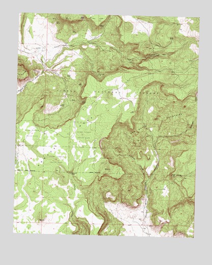
Lobo Springs, NM USGS Topographic Map
Click on map above to begin viewing in our Map Viewer.

This topographic map contains these locations and features:
Feature Name Type Latitude Longitude GNIS ID View Map
Acoma Pueblo Indian LandAreaN35.1678°W107.7220°902980View Map
Big SpringSpringN35.1954°W107.6694°903813View Map
Boone MineMineN35.1564°W107.6528°916426View Map
Cliff SpringSpringN35.2451°W107.7247°905211View Map
Coal Mine Canyon Picnic AreaLocaleN35.2336°W107.7014°914161View Map
De Armand SpringSpringN35.1599°W107.7115°905626View Map
East Lobo SpringSpringN35.2104°W107.7080°908106View Map
Guadalupe CanyonValleyN35.1575°W107.6570°906757View Map
Hill Number Seven MineMineN35.2164°W107.7373°917873View Map
Horace MesaSummitN35.2053°W107.6859°907081View Map
Little Turkey SpringSpringN35.2162°W107.6951°908060View Map
Lobo Canyon Volunteer Fire DepartmentBuildingN35.2158°W107.7245°2658185View Map
Lobo Picnic GroundLocaleN35.2045°W107.7153°908104View Map
Lobo SpringsSpringN35.1976°W107.7177°908105View Map
Mirabel SpringSpringN35.2371°W107.6440°908802View Map
Phillips Water WellWellN35.2173°W107.6653°918536View Map
Pine SpringSpringN35.2400°W107.7134°909678View Map
Pumice SpringSpringN35.2470°W107.7248°914164View Map
Revis SpringSpringN35.2481°W107.7057°910149View Map
Rinconada CanyonValleyN35.1334°W107.6609°910212View Map
Rinconada MineMineN35.1839°W107.6717°916894View Map
San Mateo MountainsRangeN35.1906°W107.6539°920695View Map
Telephone SpringSpringN35.2433°W107.6929°911596View Map
Tiet jen RanchLocaleN35.2148°W107.7137°911705View Map
Turkey SpringSpringN35.2007°W107.7054°911897View Map
Turkey Springs PitMineN35.2248°W107.7401°916909View Map
Twin SpringSpringN35.2460°W107.6416°911937View Map

Note: Coordinates in the location and feature list above are referenced to NAD83 datum.


Copyright (C) 2008-2024 Ryan Niemi / Sunset Dynamics ... All Rights Reserved