TopoQuest Logo
Do you find TopoQuest useful?
Help keep TopoQuest running and adding new maps/features by donating!
Bitcoin:  19c7KJd3qBynnjoSw5npx9KScwjBe4ifkT
Litecoin:  LXs6TkuXGGXo1vDsWCkWVdjQX94eUKd6ui
Home View Maps Find Maps Find Places Resources & Links


McCartys, New Mexico Topographic Map

USGS Map Title: McCartys, NM
USGS Map MRC: 35107A6
DRG (GeoTIFF) Download: o35107a6.tif


Neighboring USGS Topographic Map Quads:


  Grants, NM  
35107B7
 

  Lobo Springs, NM  
35107B6
 

  Mount Taylor, NM  
35107B5
 

  Grants SE, NM  
35107A7
 

  McCartys, NM  
35107A6
 

  Cubero, NM  
35107A5
 

  Los Pilares, NM  
34107H7
 

  Crow Point, NM  
34107H6
 

  Acoma Pueblo, NM  
34107H5


Map MRC Location:

N36°
W108°
N36°
W107°
H8 H7 H6 H5 H4 H3 H2 H1
G8 G7 G6 G5 G4 G3 G2 G1
F8 F7 F6 F5 F4 F3 F2 F1
E8 E7 E6 E5 E4 E3 E2 E1
D8 D7 D6 D5 D4 D3 D2 D1
C8 C7 C6 C5 C4 C3 C2 C1
B8 B7 B6 B5 B4 B3 B2 B1
A8 A7 A6 A5 A4 A3 A2 A1
N35°
W108°
N35°
W107°

McCartys, NM USGS 1:24K Topographic Map Preview:
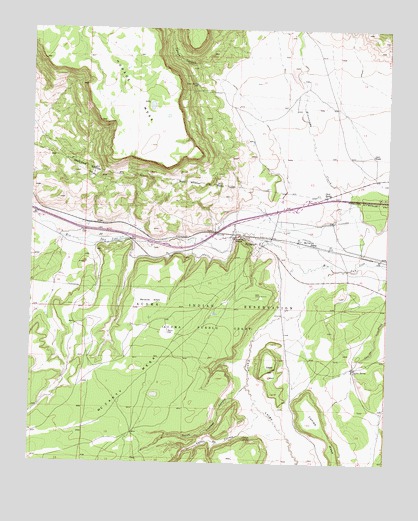
McCartys, NM USGS Topographic Map
Click on map above to begin viewing in our Map Viewer.

This topographic map contains these locations and features:
Feature Name Type Latitude Longitude GNIS ID View Map
10027 Water WellWellN35.0637°W107.6576°919626View Map
10032 Water WellWellN35.0695°W107.7498°922116View Map
Acoma 2 Water WellWellN35.0087°W107.7145°918570View Map
Airport WL Water WellWellN35.0512°W107.7106°918571View Map
AnzacPopulated PlaceN35.0687°W107.7267°899506View Map
Anzac 86-1 Water WellWellN35.0645°W107.7412°918572View Map
Anzac Village Census Designated PlaceCensusN35.0613°W107.7455°2585647View Map
Basalt QuarryMineN35.1112°W107.6645°916898View Map
Canipa MesaSummitN35.0117°W107.6528°887136View Map
Canipa SpringSpringN35.0276°W107.6372°887137View Map
Caņon de ConejoValleyN35.0109°W107.6714°897765View Map
Caņon LargoValleyN35.0512°W107.6520°897819View Map
Cedar HillSummitN35.0273°W107.6659°887330View Map
Chief RanchoLocaleN35.0775°W107.6476°887514View Map
Conejo SpringSpringN35.0076°W107.6751°887784View Map
Lane RanchLocaleN35.0892°W107.6309°890921View Map
Lane SpringSpringN35.1087°W107.6933°890923View Map
McCarty MesaSummitN35.0225°W107.7139°899744View Map
McCartysPopulated PlaceN35.0628°W107.6695°923625View Map
McCartys SidingLocaleN35.0634°W107.6526°891703View Map
McCartys Village Census Designated PlaceCensusN35.0636°W107.6835°2585648View Map
North Lumber CanyonValleyN35.0198°W107.6776°892623View Map
Santa Maria MissionChurchN35.0653°W107.6770°894576View Map
Tafoya CanyonValleyN35.1106°W107.6867°911527View Map
Test Well 3 Water WellWellN35.0642°W107.6953°918562View Map

Note: Coordinates in the location and feature list above are referenced to NAD83 datum.


Copyright (C) 2008-2025 Ryan Niemi / Sunset Dynamics ... All Rights Reserved