TopoQuest Logo
Do you find TopoQuest useful?
Help keep TopoQuest running and adding new maps/features by donating!
Bitcoin:  19c7KJd3qBynnjoSw5npx9KScwjBe4ifkT
Litecoin:  LXs6TkuXGGXo1vDsWCkWVdjQX94eUKd6ui
Home View Maps Find Maps Find Places Resources & Links


Lockhart, South Carolina Topographic Map

USGS Map Title: Lockhart, SC
USGS Map MRC: 34081G4
DRG (GeoTIFF) Download: o34081g4.tif


Neighboring USGS Topographic Map Quads:


  Wilkinsville, SC  
34081H5
 

  Hickory Grove, SC  
34081H4
 

  Sharon, SC  
34081H3
 

  Kelton, SC  
34081G5
 

  Lockhart, SC  
34081G4
 

  Armenia, SC  
34081G3
 

  Union East, SC  
34081F5
 

  Leeds, SC  
34081F4
 

  Baton Rouge, SC  
34081F3


Map MRC Location:

N35°
W82°
N35°
W81°
H8 H7 H6 H5 H4 H3 H2 H1
G8 G7 G6 G5 G4 G3 G2 G1
F8 F7 F6 F5 F4 F3 F2 F1
E8 E7 E6 E5 E4 E3 E2 E1
D8 D7 D6 D5 D4 D3 D2 D1
C8 C7 C6 C5 C4 C3 C2 C1
B8 B7 B6 B5 B4 B3 B2 B1
A8 A7 A6 A5 A4 A3 A2 A1
N34°
W82°
N34°
W81°

Lockhart, SC USGS 1:24K Topographic Map Preview:
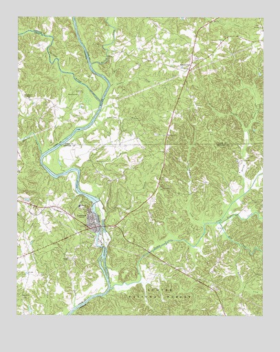
Lockhart, SC USGS Topographic Map
Click on map above to begin viewing in our Map Viewer.

This topographic map contains these locations and features:
Feature Name Type Latitude Longitude GNIS ID View Map
Bullock CreekStreamN34.8554°W81.4620°1229483View Map
Bullock CreekPopulated PlaceN34.8543°W81.4118°1247063View Map
Bullock Creek Presbyterian Church GraveyardCemeteryN34.8579°W81.4090°1247997View Map
Bullock Creek School (historical)SchoolN34.8540°W81.4101°1233621View Map
Bullocks Creek Presbyterian ChurchChurchN34.8574°W81.4120°1233620View Map
CabalPopulated PlaceN34.8065°W81.4526°1230641View Map
Cotton (historical)Populated PlaceN34.8315°W81.4220°1233678View Map
Cross Roads Fire DepartmentBuildingN34.8074°W81.4505°2578718View Map
Cross Roads School (historical)SchoolN34.8046°W81.4279°1230671View Map
Crossroads ChurchChurchN34.8035°W81.4256°1247448View Map
Cudds PondReservoirN34.7525°W81.4931°1239519View Map
Cudds Pond Dam D-2158DamN34.7518°W81.4932°1239518View Map
Dry Branch School (historical)SchoolN34.8424°W81.4120°1233689View Map
Dry CreekStreamN34.8471°W81.4512°1229655View Map
Emmanuel School (historical)SchoolN34.8451°W81.4993°1232875View Map
Fanning CreekStreamN34.8174°W81.4870°1247728View Map
George BranchStreamN34.8110°W81.4682°1229726View Map
Gist - Giles - Pinckneyville CemeteryCemeteryN34.8362°W81.4904°1232906View Map
Goods Island (historical)IslandN34.8682°W81.4698°1233742View Map
Gould (historical)Populated PlaceN34.8604°W81.4473°1233743View Map
Hainey School (historical)SchoolN34.7510°W81.4965°1232918View Map
LockhartPopulated PlaceN34.7865°W81.4620°1229941View Map
Lockhart ChapelChurchN34.7735°W81.4740°1229942View Map
Lockhart DamDamN34.7985°W81.4598°1238823View Map
Lockhart Elementary SchoolSchoolN34.7960°W81.4682°1232953View Map
Lockhart Fire DepartmentBuildingN34.7885°W81.4625°2578237View Map
Lockhart High SchoolSchoolN34.7960°W81.4676°1232954View Map
Lockhart Lower ShoalsBarN34.7649°W81.4534°1232956View Map
Lockhart ReservoirReservoirN34.7985°W81.4598°1238824View Map
Lockharts CanalaCanalN34.7890°W81.4584°1232955View Map
Lockharts Upper ShoalsBarN34.7985°W81.4612°1232957View Map
Loves FordCrossingN34.7724°W81.4554°1230717View Map
McKelvey CreekStreamN34.7876°W81.4048°1229987View Map
Mill CreekStreamN34.7890°W81.3968°1230011View Map
Mount Hopewell ChurchChurchN34.8257°W81.4234°1230054View Map
Mount Pleasant Church (historical)ChurchN34.8357°W81.4284°1233805View Map
Nelson CreekStreamN34.8468°W81.4523°1230092View Map
New Emanuel ChapelChurchN34.8412°W81.4937°1249796View Map
No Mans Land (historical)Populated PlaceN34.7801°W81.4670°1232995View Map
Osborn BranchStreamN34.7929°W81.4543°1230132View Map
Pacolet RiverStreamN34.8399°W81.4576°1250005View Map
Palmer BranchStreamN34.8276°W81.3829°1230138View Map
PinckneyPopulated PlaceN34.8407°W81.4957°1233003View Map
Pinckney CemeteryCemeteryN34.8432°W81.4684°1233004View Map
Pinckney Ferry (historical)CrossingN34.8393°W81.4573°1251750View Map
PinckneyvillePopulated PlaceN34.8429°W81.4684°1231655View Map
Pinckneyville Courthouse (historical)BuildingN34.8432°W81.4684°1241322View Map
Poolus Loop Hunt CampLocaleN34.7507°W81.4568°1230556View Map
Rainey BranchStreamN34.8012°W81.3840°1250287View Map
Red HillPopulated PlaceN34.7579°W81.4970°1233012View Map
Red Hill ChurchChurchN34.7585°W81.4965°1250310View Map
Robertson BranchStreamN34.8318°W81.4604°1250406View Map
Rodens CreekStreamN34.7796°W81.3865°1250458View Map
Saint Luke Baptist Number 2 ChurchChurchN34.8715°W81.3762°1250582View Map
Susybole CreekStreamN34.7887°W81.3965°1251080View Map
Thompson Ferry (historical)CrossingN34.8001°W81.4648°1230761View Map
Town of LockhartCivilN34.7924°W81.4614°2406034View Map
Turkey CreekStreamN34.7615°W81.4523°1230427View Map

Note: Coordinates in the location and feature list above are referenced to NAD83 datum.


Copyright (C) 2008-2024 Ryan Niemi / Sunset Dynamics ... All Rights Reserved