TopoQuest Logo
Do you find TopoQuest useful?
Help keep TopoQuest running and adding new maps/features by donating!
Bitcoin:  19c7KJd3qBynnjoSw5npx9KScwjBe4ifkT
Litecoin:  LXs6TkuXGGXo1vDsWCkWVdjQX94eUKd6ui
Home View Maps Find Maps Find Places Resources & Links


Hickory Grove, South Carolina Topographic Map

USGS Map Title: Hickory Grove, SC
USGS Map MRC: 34081H4
DRG (GeoTIFF) Download: o34081h4.tif


Neighboring USGS Topographic Map Quads:


  Blacksburg South, SC  
35081A5
 

  Kings Creek, SC  
35081A4
 

  Filbert, SC  
35081A3
 

  Wilkinsville, SC  
34081H5
 

  Hickory Grove, SC  
34081H4
 

  Sharon, SC  
34081H3
 

  Kelton, SC  
34081G5
 

  Lockhart, SC  
34081G4
 

  Armenia, SC  
34081G3


Map MRC Location:

N35°
W82°
N35°
W81°
H8 H7 H6 H5 H4 H3 H2 H1
G8 G7 G6 G5 G4 G3 G2 G1
F8 F7 F6 F5 F4 F3 F2 F1
E8 E7 E6 E5 E4 E3 E2 E1
D8 D7 D6 D5 D4 D3 D2 D1
C8 C7 C6 C5 C4 C3 C2 C1
B8 B7 B6 B5 B4 B3 B2 B1
A8 A7 A6 A5 A4 A3 A2 A1
N34°
W82°
N34°
W81°

Hickory Grove, SC USGS 1:24K Topographic Map Preview:
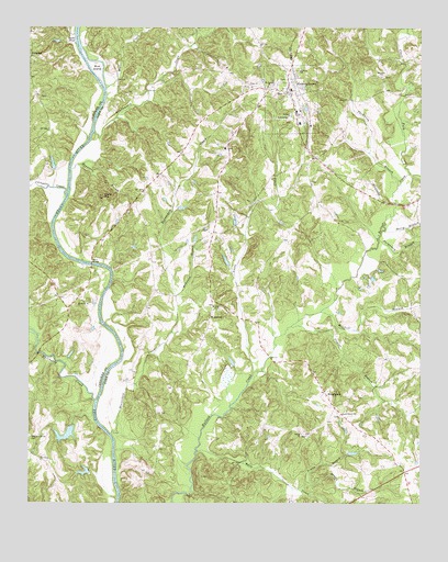
Hickory Grove, SC USGS Topographic Map
Click on map above to begin viewing in our Map Viewer.

This topographic map contains these locations and features:
Feature Name Type Latitude Longitude GNIS ID View Map
AbingdonPopulated PlaceN34.9924°W81.4995°1227860View Map
Abingdon CreekStreamN34.9562°W81.4879°1244842View Map
Beauty Spot (historical)Populated PlaceN34.8960°W81.4706°1253459View Map
Beaverdam CreekStreamN34.8932°W81.4737°1249444View Map
Bells CreekStreamN34.8887°W81.4456°1246730View Map
Berry BranchStreamN34.9468°W81.3862°1220517View Map
Borax (historical)Populated PlaceN34.8754°W81.4331°1237451View Map
Bullock Creek Fire DepartmentBuildingN34.8850°W81.3817°2578302View Map
Clark ForkStreamN34.9618°W81.3781°983221View Map
Coon Hill School (historical)SchoolN34.9624°W81.4576°1233677View Map
Dorothy Gold MineMineN34.9968°W81.4595°1233688View Map
Dowdle BranchStreamN34.8807°W81.4115°1222084View Map
Ebenezer Methodist ChurchChurchN34.9871°W81.3873°1247628View Map
Etta (historical)Populated PlaceN34.9293°W81.4901°1228520View Map
Guyonmoore CreekStreamN34.9726°W81.4790°1245872View Map
Hickory GrovePopulated PlaceN34.9832°W81.4165°1249501View Map
Hickory Grove DivisionCivilN34.9411°W81.4028°1938297View Map
Hickory Grove Fire DepartmentBuildingN34.9739°W81.4131°2578431View Map
Hickory Grove Lifesaving SquadBuildingN34.9836°W81.4168°2739609View Map
Hickory Grove School (historical)SchoolN34.9904°W81.4154°1233755View Map
Hickory Grove-Sharon Elementary SchoolSchoolN34.9779°W81.4148°1233756View Map
Holiness ChurchChurchN34.9590°W81.4098°1233760View Map
HoodtownPopulated PlaceN34.9004°W81.4020°1231401View Map
HopewellPopulated PlaceN34.9268°W81.4412°1227920View Map
Hopewell School (historical)SchoolN34.9182°W81.4440°1252128View Map
Howells Ferry (historical)CrossingN34.9279°W81.4768°1251745View Map
Irene BridgeBridgeN34.9379°W81.4795°1223458View Map
Loves CreekStreamN34.9087°W81.4284°1224207View Map
Mattox Pond Dam D-3421DamN34.9618°W81.4915°1239942View Map
McDaniel BranchStreamN34.9296°W81.4529°1224401View Map
McGowan IslandIslandN34.9715°W81.4795°1233795View Map
Mitchell BranchStreamN34.9254°W81.4065°1224602View Map
Mount Vernon United Methodist ChurchChurchN34.9846°W81.4240°1249696View Map
Mount Zion Number 2 African Methodist Episcopal Zion ChurchChurchN34.9262°W81.4393°1249733View Map
Mountain BranchStreamN34.9629°W81.4862°1224849View Map
Mud CreekStreamN34.9840°W81.4754°1249755View Map
Mud IslandIslandN34.9893°W81.4787°1224872View Map
Pleasant Grove CemeteryCemeteryN34.8926°W81.4993°1225531View Map
Pleasant Grove Church (historical)ChurchN34.8932°W81.4987°1237434View Map
Pleasant Grove School (historical)SchoolN34.8932°W81.4987°1228629View Map
Plexico BranchStreamN34.9215°W81.4159°1225561View Map
Prater BranchStreamN34.8787°W81.4143°1225657View Map
Purgatory BranchStreamN34.9446°W81.3881°1225709View Map
Quinton BranchStreamN34.9985°W81.4856°1225724View Map
Saint James African Methodist Episcopal ChurchChurchN34.9768°W81.4162°1250527View Map
Saint Paul Church (historical)ChurchN34.8904°W81.4576°1252638View Map
Saint Pauls Baptist ChurchChurchN34.9885°W81.4137°1250678View Map
Salem ChurchChurchN34.9274°W81.4809°1250728View Map
Shady Grove ChurchChurchN34.8985°W81.4004°1226522View Map
Shiloh Baptist ChurchChurchN34.8932°W81.4126°1250877View Map
Shiloh School (historical)SchoolN34.9129°W81.4137°1233911View Map
Smith FordPopulated PlaceN34.9968°W81.4854°1231807View Map
Smith Ford School (historical)SchoolN34.9785°W81.4945°1228651View Map
Smith School (historical)SchoolN34.9857°W81.4679°1233916View Map
Smiths FordCrossingN34.9962°W81.4845°1235289View Map
Smiths Ford Ferry (historical)CrossingN34.9962°W81.4845°1228652View Map
South Carolina Noname 11010 D-3422 DamDamN34.8951°W81.4865°1237921View Map
South Carolina Noname 11011 D-3423 DamDamN34.8835°W81.4831°1237922View Map
Thicketty CreekStreamN34.9018°W81.4784°1251151View Map
Thompson BranchStreamN34.9587°W81.3820°1227099View Map
Town of Hickory GroveCivilN34.9785°W81.4181°2405824View Map
Unity Baptist ChurchChurchN34.9846°W81.4290°1251277View Map
Wilkerson School (historical)SchoolN34.9551°W81.4634°1233965View Map
Worth MountainSummitN34.9554°W81.4762°1227710View Map

Note: Coordinates in the location and feature list above are referenced to NAD83 datum.


Copyright (C) 2008-2025 Ryan Niemi / Sunset Dynamics ... All Rights Reserved