TopoQuest Logo
Do you find TopoQuest useful?
Help keep TopoQuest running and adding new maps/features by donating!
Bitcoin:  19c7KJd3qBynnjoSw5npx9KScwjBe4ifkT
Litecoin:  LXs6TkuXGGXo1vDsWCkWVdjQX94eUKd6ui
Home View Maps Find Maps Find Places Resources & Links


Lois, Tennessee Topographic Map

USGS Map Title: Lois, TN
USGS Map MRC: 35086B3
DRG (GeoTIFF) Download: o35086b3.tif


Neighboring USGS Topographic Map Quads:


  Lynchburg West, TN  
35086C4
 

  Lynchburg East, TN  
35086C3
 

  Tullahoma, TN  
35086C2
 

  Mulberry, TN  
35086B4
 

  Lois, TN  
35086B3
 

  Belvidere, TN  
35086B2
 

  Flintville, TN  
35086A4
 

  Huntland, TN  
35086A3
 

  Beans Creek, TN  
35086A2


Map MRC Location:

N36°
W87°
N36°
W86°
H8 H7 H6 H5 H4 H3 H2 H1
G8 G7 G6 G5 G4 G3 G2 G1
F8 F7 F6 F5 F4 F3 F2 F1
E8 E7 E6 E5 E4 E3 E2 E1
D8 D7 D6 D5 D4 D3 D2 D1
C8 C7 C6 C5 C4 C3 C2 C1
B8 B7 B6 B5 B4 B3 B2 B1
A8 A7 A6 A5 A4 A3 A2 A1
N35°
W87°
N35°
W86°

Lois, TN USGS 1:24K Topographic Map Preview:
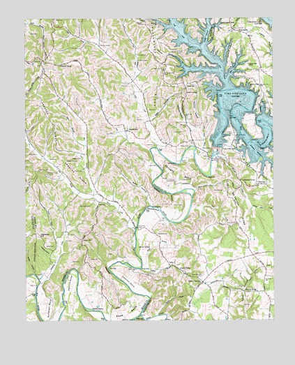
Lois, TN USGS Topographic Map
Click on map above to begin viewing in our Map Viewer.

This topographic map contains these locations and features:
Feature Name Type Latitude Longitude GNIS ID View Map
Anderton BranchStreamN35.2309°W86.2950°1304836View Map
Anderton Branch Public Use AreaParkN35.2259°W86.2978°1318585View Map
Arbor Church (historical)ChurchN35.2156°W86.3542°1317879View Map
Ashby CemeteryCemeteryN35.2437°W86.3683°1275939View Map
Bean CemeteryCemeteryN35.1890°W86.3089°1276535View Map
Bean CemeteryCemeteryN35.2123°W86.3089°1276536View Map
Bean HollowValleyN35.1726°W86.3116°1276539View Map
Bean HollowValleyN35.2082°W86.3116°1276540View Map
Beans CreekStreamN35.1270°W86.3178°1276546View Map
Bear BranchStreamN35.1973°W86.3436°1276551View Map
Beech HillPopulated PlaceN35.2223°W86.2939°1314653View Map
Beech Hill CemeteryCemeteryN35.2209°W86.2930°1318495View Map
Beech Hill ChurchChurchN35.2220°W86.2933°1318493View Map
Beech Hill School (historical)SchoolN35.2215°W86.2933°1318494View Map
Blue HoleLakeN35.1468°W86.3330°1277762View Map
Brandon ChapelChurchN35.2387°W86.3369°1305391View Map
Browington CemeteryCemeteryN35.2426°W86.2617°1318489View Map
Browington Church of the NazareneChurchN35.2426°W86.2619°1318490View Map
BrowningtonPopulated PlaceN35.2448°W86.2667°1278615View Map
Bull RunStreamN35.2240°W86.3205°1305515View Map
Cashion BendBendN35.1415°W86.3233°1305719View Map
Cashion RidgeRidgeN35.1420°W86.3089°1647469View Map
Cline RidgeRidgeN35.1920°W86.2667°1280749View Map
Cline Ridge Cabin SitesLocaleN35.1884°W86.2594°1318482View Map
Cobble CemeteryCemeteryN35.2348°W86.3175°1280833View Map
Coffee CreekStreamN35.1967°W86.3086°1269477View Map
Collins BranchStreamN35.1468°W86.3164°1280986View Map
Commissioner District 3CivilN35.2049°W86.3389°2464181View Map
Cooper BranchStreamN35.2390°W86.2844°1281186View Map
Copeland HillSummitN35.1604°W86.3678°1281248View Map
Crossroads CemeteryCemeteryN35.1434°W86.2864°1281723View Map
Cynthia HollowValleyN35.2318°W86.2744°1281916View Map
Damron HollowValleyN35.2053°W86.2874°1282000View Map
Damron SpringSpringN35.2190°W86.2883°1282001View Map
Davis School (historical)SchoolN35.2415°W86.3083°1317883View Map
Derrick BendBendN35.1401°W86.3528°1282362View Map
Dry Prong Farris CreekStreamN35.1759°W86.3200°1303442View Map
Ebenezer Church (historical)ChurchN35.2048°W86.3119°1317885View Map
Edde BendBendN35.1284°W86.3239°1283501View Map
Edde BluffCliffN35.1459°W86.3339°1283502View Map
Ervin CemeteryCemeteryN35.1581°W86.3550°1283845View Map
Farris CreekStreamN35.1631°W86.3200°1284157View Map
Farris Creek BridgeBridgeN35.1637°W86.3189°1284158View Map
Frame CemeteryCemeteryN35.1870°W86.3458°1284796View Map
Franklin CemeteryCemeteryN35.1726°W86.2955°1284821View Map
Fuga School (historical)SchoolN35.1959°W86.3700°1317878View Map
Galloway HollowValleyN35.2056°W86.2927°1285106View Map
Garner FordCrossingN35.1909°W86.2967°1315095View Map
Gray CemeteryCemeteryN35.2081°W86.3153°1285987View Map
Gray CemeteryCemeteryN35.2223°W86.3225°1285988View Map
Gregory CemeteryCemeteryN35.1973°W86.2922°1286237View Map
Gum Springs Church (historical)ChurchN35.2176°W86.3747°1317880View Map
Hall CemeteryCemeteryN35.1312°W86.2622°1286557View Map
Harmony CemeteryCemeteryN35.1812°W86.2572°1318480View Map
Harmony Cumberland Presbyterian ChurchChurchN35.1806°W86.2578°1318479View Map
Harmony School (historical)SchoolN35.1812°W86.2586°1318481View Map
Harmony SpringSpringN35.1829°W86.2650°1286903View Map
Hasty HollowValleyN35.2468°W86.3011°1287101View Map
Hatchett HollowValleyN35.2105°W86.2547°1287113View Map
Hawkersmith CemeteryCemeteryN35.2181°W86.3014°1318492View Map
HurdlowPopulated PlaceN35.1740°W86.3375°1315277View Map
Hurdlow School (historical)SchoolN35.1784°W86.3386°1317876View Map
Jollys RockCapeN35.1959°W86.2564°1289683View Map
Kings HoleLakeN35.1465°W86.3167°1290245View Map
Kitchens CemeteryCemeteryN35.1962°W86.2814°1290319View Map
LexiePopulated PlaceN35.1481°W86.3014°1315381View Map
Lexie CemeteryCemeteryN35.1487°W86.2997°1318473View Map
Lexie Church of ChristChurchN35.1490°W86.3000°1318472View Map
Lexie Cross Roads Baptist ChurchChurchN35.1404°W86.2861°1318474View Map
Lexie Cross Roads School (historical)SchoolN35.1398°W86.2867°1318475View Map
Lexie CrossroadsPopulated PlaceN35.1409°W86.2858°1315382View Map
Lexie Crossroads Volunteer Fire DepartmentBuildingN35.1521°W86.2578°2654643View Map
Liberty HillPopulated PlaceN35.1590°W86.3461°1315390View Map
Liberty Hill School (historical)SchoolN35.1593°W86.3453°1317875View Map
Limbaugh CemeteryCemeteryN35.1787°W86.2750°1291287View Map
LoisPopulated PlaceN35.2326°W86.3655°1291828View Map
Lois CemeteryCemeteryN35.2329°W86.3633°1322691View Map
Lois School (historical)SchoolN35.2306°W86.3667°1317882View Map
Lost CreekStreamN35.2209°W86.2719°1292077View Map
Majors CemeteryCemeteryN35.2365°W86.2967°1292523View Map
Maple Grove School (historical)SchoolN35.2395°W86.2611°1318488View Map
Marble HillPopulated PlaceN35.2034°W86.3233°1315463View Map
Marble Hill United Methodist ChurchChurchN35.2042°W86.3233°1317884View Map
Marble PlainsLocaleN35.2220°W86.2564°1292664View Map
Marble Plains CemeteryCemeteryN35.2248°W86.2642°1318486View Map
Marble Plains ChurchChurchN35.2254°W86.2642°1292665View Map
Metro Lynchburg Moore County Volunteer Fire Department Station 2 FugaBuildingN35.1953°W86.3728°2654255View Map
Moorehead CemeteryCemeteryN35.1729°W86.3422°1294309View Map
Mount Vernon CemeteryCemeteryN35.1648°W86.2678°1318476View Map
Mount Vernon ChurchChurchN35.1648°W86.2683°1294824View Map
Mount Vernon RidgeRidgeN35.1698°W86.2680°1294834View Map
Mount Vernon School (historical)SchoolN35.1801°W86.2730°1318477View Map
Murrell CemeteryCemeteryN35.1773°W86.2522°1318478View Map
Murrell CreekStreamN35.1923°W86.2803°1295156View Map
Narrows Cabin SitesLocaleN35.1981°W86.2694°1318483View Map
Neal CemeteryCemeteryN35.1390°W86.2689°1295276View Map
Neal CreekStreamN35.1709°W86.2922°1295283View Map
Oak Grove CemeteryCemeteryN35.1870°W86.3678°1296066View Map
Oak Grove Church (historical)ChurchN35.1870°W86.3678°1317877View Map
Parks IslandIslandN35.1301°W86.3389°1296856View Map
Parks Mill (historical)LocaleN35.2209°W86.2694°1318487View Map
Pleasant Hill CemeteryCemeteryN35.1912°W86.3542°1297849View Map
Porter CemeteryCemeteryN35.1437°W86.3692°1298249View Map
Porter School (historical)SchoolN35.1434°W86.3686°1317874View Map
Possumtrot RidgeRidgeN35.2309°W86.3058°1298310View Map
Quarles BranchStreamN35.1273°W86.3089°1298742View Map
Ray BranchStreamN35.2259°W86.2722°1298983View Map
Reed CemeteryCemeteryN35.1917°W86.3628°1299122View Map
Reston RidgeRidgeN35.1945°W86.3589°1299234View Map
Robinson CreekStreamN35.1409°W86.3675°1299703View Map
Sheep HollowValleyN35.1447°W86.3707°1269958View Map
Shelton CemeteryCemeteryN35.1495°W86.3519°1270012View Map
Short CreekStreamN35.1915°W86.3105°1270184View Map
Smith BranchStreamN35.1470°W86.3155°1270555View Map
Smith ChapelChurchN35.2326°W86.3175°1270657View Map
Smith IslandFlatN35.1556°W86.3153°1270697View Map
Snow CemeteryCemeteryN35.1940°W86.3692°1270777View Map
Stiles FordCrossingN35.1395°W86.3692°1314338View Map
Sugartree SpringSpringN35.1373°W86.2650°1303913View Map
Sullenger BendBendN35.1301°W86.3633°1303914View Map
Sylvanus School (historical)SchoolN35.2223°W86.2567°1318485View Map
Templeton BranchStreamN35.1251°W86.3350°1272291View Map
The NarrowsGapN35.2095°W86.2717°1272420View Map
Tims Ford BridgesBridgeN35.1920°W86.2808°1318484View Map
Tims Ford DamDamN35.1964°W86.2787°1304111View Map
Tipps CemeteryCemeteryN35.1987°W86.3233°1272674View Map
Travis CemeteryCemeteryN35.1976°W86.3097°1272846View Map
Travis CemeteryCemeteryN35.2029°W86.3000°1272847View Map
Tripp HollowValleyN35.1572°W86.3586°1647447View Map
Turn HoleLakeN35.1848°W86.2819°1273053View Map
Union CemeteryCemeteryN35.2320°W86.3700°1273181View Map
Union Church (historical)ChurchN35.2320°W86.3700°1317881View Map
Union Grove CemeteryCemeteryN35.2459°W86.2705°1318491View Map
Union Grove ChurchChurchN35.2456°W86.2697°1273222View Map
Vanzant BendBendN35.1854°W86.2983°1273384View Map
Vanzant CemeteryCemeteryN35.1829°W86.2997°1273385View Map
Vanzant CemeteryCemeteryN35.1831°W86.2958°1273386View Map
Vanzant SpringSpringN35.1462°W86.2972°1273387View Map
Waggoner CemeteryCemeteryN35.1920°W86.3461°1273525View Map
Wagoner HollowValleyN35.1937°W86.3125°1647448View Map
Wakefield BendBendN35.1712°W86.3108°1273539View Map
Wakefield CemeteryCemeteryN35.1606°W86.3089°1273540View Map
Walker CemeteryCemeteryN35.1559°W86.3603°1273582View Map
Walker HollowValleyN35.1508°W86.3593°1273623View Map
Waller CemeteryCemeteryN35.1506°W86.3425°1273694View Map
Water Cure CreekStreamN35.1723°W86.2608°1273878View Map
West Fork Robinson CreekStreamN35.1562°W86.3575°1274187View Map
Wet Prong Farris CreekStreamN35.1762°W86.3405°1304504View Map
Wiseman BendBendN35.1995°W86.2536°1274903View Map
Wiseman BendBendN35.1659°W86.3000°1311184View Map
Wiseman BranchStreamN35.1987°W86.2622°1274904View Map
Wiseman SpringSpringN35.2306°W86.3567°1274908View Map

Note: Coordinates in the location and feature list above are referenced to NAD83 datum.


Copyright (C) 2008-2024 Ryan Niemi / Sunset Dynamics ... All Rights Reserved