TopoQuest Logo
Do you find TopoQuest useful?
Help keep TopoQuest running and adding new maps/features by donating!
Bitcoin:  19c7KJd3qBynnjoSw5npx9KScwjBe4ifkT
Litecoin:  LXs6TkuXGGXo1vDsWCkWVdjQX94eUKd6ui
Home View Maps Find Maps Find Places Resources & Links


Lynchburg West, Tennessee Topographic Map

USGS Map Title: Lynchburg West, TN
USGS Map MRC: 35086C4
DRG (GeoTIFF) Download: o35086c4.tif


Neighboring USGS Topographic Map Quads:


  Bedford, TN  
35086D5
 

  Shelbyville, TN  
35086D4
 

  Normandy, TN  
35086D3
 

  Belleville, TN  
35086C5
 

  Lynchburg West, TN  
35086C4
 

  Lynchburg East, TN  
35086C3
 

  Fayetteville, TN  
35086B5
 

  Mulberry, TN  
35086B4
 

  Lois, TN  
35086B3


Map MRC Location:

N36°
W87°
N36°
W86°
H8 H7 H6 H5 H4 H3 H2 H1
G8 G7 G6 G5 G4 G3 G2 G1
F8 F7 F6 F5 F4 F3 F2 F1
E8 E7 E6 E5 E4 E3 E2 E1
D8 D7 D6 D5 D4 D3 D2 D1
C8 C7 C6 C5 C4 C3 C2 C1
B8 B7 B6 B5 B4 B3 B2 B1
A8 A7 A6 A5 A4 A3 A2 A1
N35°
W87°
N35°
W86°

Lynchburg West, TN USGS 1:24K Topographic Map Preview:
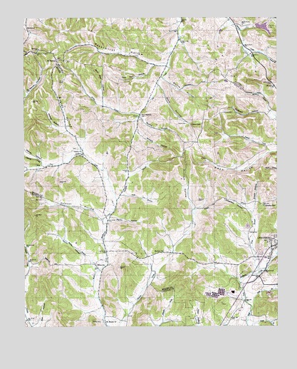
Lynchburg West, TN USGS Topographic Map
Click on map above to begin viewing in our Map Viewer.

This topographic map contains these locations and features:
Feature Name Type Latitude Longitude GNIS ID View Map
Anderson HollowValleyN35.3360°W86.3794°1304832View Map
Bagley HollowValleyN35.3243°W86.4727°1276085View Map
Bailey BranchStreamN35.2726°W86.4636°1276090View Map
Bartlett HollowValleyN35.3142°W86.4985°1276404View Map
Baxter CemeteryCemeteryN35.2998°W86.3914°1322676View Map
Bedford HollowValleyN35.3372°W86.3783°1276754View Map
Black Bottom School (historical)SchoolN35.2812°W86.4600°1316179View Map
Boone CemeteryCemeteryN35.3695°W86.4242°1319246View Map
BoonevillePopulated PlaceN35.2742°W86.4644°1277985View Map
Booneville CemeteryCemeteryN35.2770°W86.4608°1645179View Map
Buckeye CemeteryCemeteryN35.3012°W86.4142°1278848View Map
Buckeye ChurchChurchN35.2801°W86.4317°1278850View Map
Buckeye HollowValleyN35.2971°W86.4158°1278856View Map
Carter HollowValleyN35.3189°W86.4931°1311041View Map
Charity CemeteryCemeteryN35.3223°W86.4739°1322679View Map
Charity ChurchChurchN35.3209°W86.4711°1305861View Map
Charity CreekStreamN35.3156°W86.4914°1269442View Map
Charity SchoolSchoolN35.3162°W86.4922°1280270View Map
Commissioner District 1CivilN35.2707°W86.3827°2464269View Map
Cox CemeteryCemeteryN35.3134°W86.4939°1281481View Map
Eden CemeteryCemeteryN35.2992°W86.3822°1283507View Map
Eden HollowValleyN35.3211°W86.3781°1283510View Map
Elaine LakeReservoirN35.3710°W86.3816°1301776View Map
Elaine Lake DamDamN35.3717°W86.3850°1301777View Map
Enoch HollowValleyN35.2956°W86.3868°1283806View Map
Farrar BranchStreamN35.3612°W86.3847°1284151View Map
Floyd CemeteryCemeteryN35.3665°W86.4217°1319311View Map
Gase CemeteryCemeteryN35.2701°W86.4394°1645222View Map
Glendale School (historical)SchoolN35.3545°W86.3944°1319321View Map
HawthornePopulated PlaceN35.3712°W86.4986°1315208View Map
Highview CemeteryCemeteryN35.2845°W86.3794°1322687View Map
Highview School (historical)SchoolN35.2842°W86.3789°1317886View Map
Hobbs HillSummitN35.2967°W86.4083°1287937View Map
Jack Daniel Distillery Fire BrigadeBuildingN35.2640°W86.3997°2653865View Map
John Allen HollowValleyN35.3404°W86.4609°1289476View Map
Johnston CemeteryCemeteryN35.2631°W86.4794°1645252View Map
Kinkaid HollowValleyN35.3290°W86.4443°1290265View Map
Kirby BranchStreamN35.3359°W86.4436°1290280View Map
Logan CemeteryCemeteryN35.2592°W86.4544°1645265View Map
Lynchburg City CemeteryCemeteryN35.2856°W86.3772°1322692View Map
Lyon CemeteryCemeteryN35.3609°W86.4319°1319395View Map
Martin HollowValleyN35.2767°W86.4670°1292839View Map
Martin HollowValleyN35.2936°W86.4572°1292840View Map
McNatt FarmLocaleN35.2822°W86.4978°2724595View Map
McNatt HollowValleyN35.3290°W86.4791°1293438View Map
Mercer Manor FarmLocaleN35.3736°W86.4253°2652557View Map
Metro Lynchburg Moore County Volunteer Fire Department HeadquartersBuildingN35.2816°W86.3784°2653650View Map
Metro Lynchburg Moore County Volunteer Fire Department Station 5 CharityBuildingN35.3220°W86.4711°2654212View Map
Metro Moore County Ambulance ServiceBuildingN35.2808°W86.3781°2697470View Map
Metro Moore County Sheriff's DepartmentBuildingN35.2812°W86.3781°2765898View Map
Moore CemeteryCemeteryN35.2515°W86.4986°1645287View Map
Moore County Highway Department QuarryMineN35.2781°W86.3914°2633401View Map
Morris CemeteryCemeteryN35.3323°W86.4203°1294416View Map
Morris CemeteryCemeteryN35.3506°W86.4122°1319416View Map
Morris HollowValleyN35.2974°W86.4152°1647442View Map
Morris HollowValleyN35.3510°W86.4309°1294433View Map
Motlow CemeteryCemeteryN35.2879°W86.3889°1294527View Map
Mount HermanPopulated PlaceN35.3584°W86.4842°1294630View Map
Mount Herman Church of ChristChurchN35.3579°W86.4805°1310147View Map
Mount Herman Church of the NazareneChurchN35.3612°W86.4867°1310148View Map
Mount Moriah ChurchChurchN35.2517°W86.4603°1294675View Map
Mullins HollowValleyN35.3349°W86.4426°1295091View Map
New HermanPopulated PlaceN35.3351°W86.4433°1295495View Map
New Herman CemeteryCemeteryN35.3351°W86.4422°1319425View Map
New Herman Church of ChristChurchN35.3356°W86.4422°1310149View Map
New Herman School (historical)SchoolN35.3451°W86.4375°1323593View Map
New Mount Herman CemeteryCemeteryN35.3576°W86.4792°1319427View Map
Old Mount Herman CemeteryCemeteryN35.3587°W86.4817°1319440View Map
Parker CemeteryCemeteryN35.3403°W86.4553°1319447View Map
Pearson CemeteryCemeteryN35.3584°W86.3833°1319449View Map
Pitts BranchStreamN35.2579°W86.3875°1297754View Map
Polecat HollowValleyN35.2936°W86.4611°1298043View Map
Possumtrot BranchStreamN35.3567°W86.4278°1313198View Map
Possumtrot HollowValleyN35.3561°W86.4304°1298309View Map
Price BranchStreamN35.2717°W86.3878°1298490View Map
Raby CemeteryCemeteryN35.3453°W86.4986°1298781View Map
Raby HollowValleyN35.3227°W86.4707°1647441View Map
Ray BranchStreamN35.3698°W86.3930°1298985View Map
Reed HollowValleyN35.2688°W86.4662°1647413View Map
Rees CemeteryCemeteryN35.3015°W86.4908°1299175View Map
Robertson HollowValleyN35.2965°W86.3881°1299672View Map
Roe HollowValleyN35.2508°W86.4938°1299969View Map
Rudd BranchStreamN35.3034°W86.4525°1300230View Map
Rutledge CemeteryCemeteryN35.2917°W86.4947°1645319View Map
Sam Hart HollowValleyN35.3557°W86.4364°1300624View Map
Sebastian PondLakeN35.2988°W86.3815°1301010View Map
Shofner CemeteryCemeteryN35.2520°W86.4625°1270151View Map
Spankem BranchStreamN35.3015°W86.4547°1303746View Map
Stacy CemeteryCemeteryN35.3626°W86.4467°1319500View Map
Waggoner-Buckeye CemeteryCemeteryN35.2806°W86.4314°1322706View Map
Wagoner HillSummitN35.2759°W86.4900°1273537View Map
Ward HollowValleyN35.3477°W86.4335°1273790View Map
Warren HollowValleyN35.3165°W86.4904°1273840View Map
Wiles CemeteryCemeteryN35.2906°W86.4886°1645349View Map
Womack CemeteryCemeteryN35.3370°W86.4017°1275006View Map
WTNX-AM (Lynchburg)TowerN35.3004°W86.3922°1639848View Map

Note: Coordinates in the location and feature list above are referenced to NAD83 datum.


Copyright (C) 2008-2025 Ryan Niemi / Sunset Dynamics ... All Rights Reserved