TopoQuest Logo
Do you find TopoQuest useful?
Help keep TopoQuest running and adding new maps/features by donating!
Bitcoin:  19c7KJd3qBynnjoSw5npx9KScwjBe4ifkT
Litecoin:  LXs6TkuXGGXo1vDsWCkWVdjQX94eUKd6ui
Home View Maps Find Maps Find Places Resources & Links


Long Island Lake, Minnesota Topographic Map

USGS Map Title: Long Island Lake, MN
USGS Map MRC: 48090A7
DRG (GeoTIFF) Download: o48090a7.tif


Neighboring USGS Topographic Map Quads:


  Munker Island, MN  
48090B8
 

  Conners Island, MN  
48090B7


  Gillis Lake, MN  
48090A8
 

  Long Island Lake, MN  
48090A7
 

  Gunflint Lake, MN  
48090A6
 

  Kelso Mountain, MN  
47090H8
 

  Cherokee Lake, MN  
47090H7
 

  Brule Lake, MN  
47090H6


Map MRC Location:

N49°
W91°
N49°
W90°
H8 H7 H6 H5 H4 H3 H2 H1
G8 G7 G6 G5 G4 G3 G2 G1
F8 F7 F6 F5 F4 F3 F2 F1
E8 E7 E6 E5 E4 E3 E2 E1
D8 D7 D6 D5 D4 D3 D2 D1
C8 C7 C6 C5 C4 C3 C2 C1
B8 B7 B6 B5 B4 B3 B2 B1
A8 A7 A6 A5 A4 A3 A2 A1
N48°
W91°
N48°
W90°

Long Island Lake, MN USGS 1:24K Topographic Map Preview:
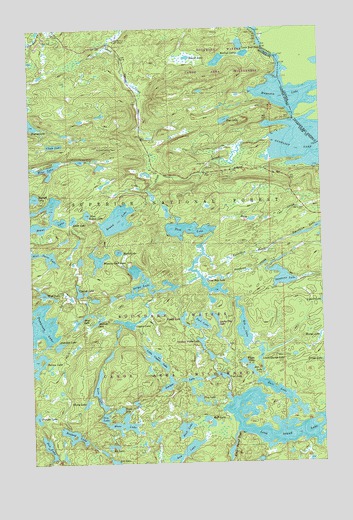
Long Island Lake, MN USGS Topographic Map
Click on map above to begin viewing in our Map Viewer.

This topographic map contains these locations and features:
Feature Name Type Latitude Longitude GNIS ID View Map
Ahgoday LakeLakeN48.0339°W90.8636°655089View Map
Auk LakeLakeN48.0034°W90.8098°655175View Map
Blue Snow LakeLakeN48.0606°W90.8704°655451View Map
Brant LakeLakeN48.0686°W90.8674°655510View Map
Burt LakeLakeN48.0095°W90.8098°655574View Map
Chub LakeLakeN48.0916°W90.8643°655725View Map
Contest LakeLakeN48.0494°W90.8547°655787View Map
Copper LakeLakeN48.0395°W90.8322°655805View Map
Cross Bay LakeLakeN48.0502°W90.7990°655889View Map
Cross RiverStreamN48.0935°W90.7718°655890View Map
Cross River LandingLocaleN48.0785°W90.8076°659210View Map
Dawkins CreekStreamN48.0527°W90.8001°655939View Map
Dawkins LakeLakeN48.0532°W90.7673°655940View Map
Din LakeLakeN48.0132°W90.8443°655995View Map
Doe LakeLakeN48.0264°W90.7810°656020View Map
Dogleg LakeLakeN48.0979°W90.8745°656022View Map
Don LakeLakeN48.0050°W90.8687°656026View Map
Edith LakeLakeN48.0701°W90.8566°656118View Map
Ell LakeLakeN48.0047°W90.8411°656144View Map
Ernest LakeLakeN48.1166°W90.8065°656167View Map
Extortion CreekStreamN48.0663°W90.7965°656185View Map
Extortion LakeLakeN48.0658°W90.7556°656186View Map
Fawn LakeLakeN48.0288°W90.7844°656211View Map
Fool LakeLakeN48.0401°W90.8027°656286View Map
Fungus LakeLakeN48.0134°W90.8736°656342View Map
Gunflint Lookout TowerTowerN48.0910°W90.8454°659848View Map
Gunflint Trail Volunteer Fire Department Station 2BuildingN48.0837°W90.7523°2666467View Map
Hairy LakeLakeN48.0172°W90.8520°656498View Map
Ham CreekStreamN48.0679°W90.7948°656504View Map
Ham LakeLakeN48.0670°W90.8075°656507View Map
Howl LakeLakeN48.0414°W90.8536°656668View Map
Hubbub LakeLakeN48.0408°W90.8468°656671View Map
Jester LakeLakeN48.0413°W90.8097°659255View Map
Juniper LakeLakeN48.0225°W90.8168°656834View Map
Karl LakeLakeN48.0210°W90.7712°656853View Map
Kerfoot LakesLakeN48.1156°W90.7934°656879View Map
Little Copper LakeLakeN48.0302°W90.8224°657046View Map
Little Rock FallsFallsN48.1188°W90.7740°657114View Map
Long Island LakeLakeN48.0083°W90.7584°657178View Map
Long Island RiverStreamN48.0088°W90.7876°657179View Map
Lower George LakeLakeN48.0308°W90.7768°657238View Map
Lucky Pay LakeLakeN48.0372°W90.7948°659254View Map
Magnetic LakeLakeN48.1064°W90.7696°657284View Map
Mass LakeLakeN48.0109°W90.8363°657338View Map
Mavis LakeLakeN48.0607°W90.8372°657340View Map
Mine LakeLakeN48.0849°W90.8666°657402View Map
Missing Link LakeLakeN48.0586°W90.8459°657421View Map
Moth LakeLakeN48.0125°W90.8007°657492View Map
Plug LakeLakeN48.0178°W90.8029°657872View Map
Pogo LakeLakeN48.0984°W90.7909°657881View Map
Ragged LakeLakeN48.0067°W90.8579°657967View Map
Rib LakeLakeN48.0388°W90.7843°658022View Map
Rib Lake TrailTrailN48.0502°W90.7654°658023View Map
Round LakeLakeN48.0700°W90.8377°658103View Map
Round Lake ParkingLocaleN48.0746°W90.8371°659209View Map
Sea Gull Forest Service StationLocaleN48.1188°W90.8390°659208View Map
Snipe LakeLakeN48.0517°W90.8262°658329View Map
Sora LakeLakeN48.0176°W90.8462°658349View Map
Swollen Ankle LakeLakeN48.0346°W90.8022°659204View Map
Tame LakeLakeN48.0153°W90.8379°658610View Map
Thelma LakeLakeN48.0292°W90.8733°658648View Map
West Round LakeLakeN48.0716°W90.8506°658958View Map
Wish LakeLakeN48.0489°W90.8694°659049View Map
Yogi LakeLakeN48.0249°W90.7935°659079View Map

Note: Coordinates in the location and feature list above are referenced to NAD83 datum.


Copyright (C) 2008-2025 Ryan Niemi / Sunset Dynamics ... All Rights Reserved