TopoQuest Logo
Do you find TopoQuest useful?
Help keep TopoQuest running and adding new maps/features by donating!
Bitcoin:  19c7KJd3qBynnjoSw5npx9KScwjBe4ifkT
Litecoin:  LXs6TkuXGGXo1vDsWCkWVdjQX94eUKd6ui
Home View Maps Find Maps Find Places Resources & Links


Louisa, Virginia Topographic Map

USGS Map Title: Louisa, VA
USGS Map MRC: 38078A1
DRG (GeoTIFF) Download: o38078a1.tif


Neighboring USGS Topographic Map Quads:


  Gordonsville, VA  
38078B2
 

  Orange, VA  
38078B1
 

  Lahore, VA  
38077B8
 

  Boswells Tavern, VA  
38078A2
 

  Louisa, VA  
38078A1
 

  Mineral, VA  
38077A8
 

  Zion Crossroads, VA  
37078H2
 

  Ferncliff, VA  
37078H1
 

  Pendleton, VA  
37077H8


Map MRC Location:

N39°
W79°
N39°
W78°
H8 H7 H6 H5 H4 H3 H2 H1
G8 G7 G6 G5 G4 G3 G2 G1
F8 F7 F6 F5 F4 F3 F2 F1
E8 E7 E6 E5 E4 E3 E2 E1
D8 D7 D6 D5 D4 D3 D2 D1
C8 C7 C6 C5 C4 C3 C2 C1
B8 B7 B6 B5 B4 B3 B2 B1
A8 A7 A6 A5 A4 A3 A2 A1
N38°
W79°
N38°
W78°

Louisa, VA USGS 1:24K Topographic Map Preview:
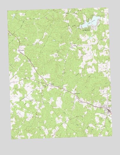
Louisa, VA USGS Topographic Map
Click on map above to begin viewing in our Map Viewer.

This topographic map contains these locations and features:
Feature Name Type Latitude Longitude GNIS ID View Map
A G Despot SchoolSchoolN38.0754°W78.0994°1462316View Map
Bethel ChurchChurchN38.0743°W78.0025°1463197View Map
Blue Ridge ShoresPopulated PlaceN38.1051°W78.0247°1495280View Map
Blue Ridge Shores Census Designated PlaceCensusN38.1091°W78.0236°2630622View Map
Bright Hope ChurchChurchN38.0507°W78.0800°1463827View Map
CutalongPopulated PlaceN38.1212°W78.0525°1495450View Map
Ebenezer ChurchChurchN38.0876°W78.0469°1466157View Map
Forest Hill ChurchChurchN38.1021°W78.1222°1466764View Map
Fox BranchStreamN38.1129°W78.0081°1466822View Map
Green SpringsPopulated PlaceN38.0860°W78.1117°1498484View Map
Green Springs Depot Post OfficePost OfficeN38.0860°W78.1117°1500362View Map
Hillcrest CemeteryCemeteryN38.0337°W78.0381°1468052View Map
Humphrey CreekStreamN38.0796°W78.0214°1468376View Map
Kents Mill (historical)LocaleN38.0787°W78.0344°1494704View Map
Lake LouisaReservoirN38.1143°W78.0111°1469873View Map
Lake LouisaReservoirN38.1112°W78.0220°1490300View Map
Lake Louisa DamDamN38.1143°W78.0111°1490299View Map
Lasley (historical)Populated PlaceN38.0301°W78.1244°1494705View Map
Lasley ChurchChurchN38.0374°W78.0992°1469147View Map
LouisaPopulated PlaceN38.0251°W78.0042°1498507View Map
Louisa County CourthouseBuildingN38.0246°W78.0036°1494708View Map
Louisa County Department of Fire and Emergency ServicesBuildingN38.0237°W78.0036°2331796View Map
Louisa County Sheriff's OfficeBuildingN38.0222°W78.0023°2331972View Map
Louisa DistrictCivilN38.0742°W78.0088°1927381View Map
Louisa Post OfficePost OfficeN38.0252°W78.0044°1759819View Map
Meyerton DamDamN38.0968°W78.0214°1490329View Map
Meyerton LakeReservoirN38.0962°W78.0237°1490330View Map
Mildred CrossingPopulated PlaceN38.0421°W78.0456°1495945View Map
North Fork Hickory CreekStreamN38.1082°W78.0469°1471608View Map
Oak Grove ChurchChurchN38.0721°W78.1242°1471730View Map
OaklandPopulated PlaceN38.0885°W78.0456°1496032View Map
Oakland CemeteryCemeteryN38.0286°W78.0116°1494721View Map
Oakland Post OfficePost OfficeN38.0885°W78.0456°1759824View Map
Ponda Roche DamDamN38.1218°W78.1131°1490331View Map
Ponda Roche LakeReservoirN38.1218°W78.1131°1490332View Map
Small Country LakeReservoirN38.0195°W78.0863°1490340View Map
Small DamDamN38.0201°W78.0864°1490339View Map
South Fork Hickory CreekStreamN38.1079°W78.0472°1474855View Map
Talleys Store (historical)LocaleN38.0296°W78.0875°1494728View Map
Taylor CemeteryCemeteryN38.0940°W78.0086°1494729View Map
TreviliansPopulated PlaceN38.0515°W78.0728°1496323View Map
Trevilians Elementary SchoolSchoolN38.0756°W78.0999°2465303View Map
Trevilians Post OfficePost OfficeN38.0515°W78.0728°1759828View Map
Trevilians Volunteer Fire Department Company 6BuildingN38.0958°W78.0364°2075277View Map
Trevillians Volunteer Fire / Rescue DepartmentBuildingN38.0948°W78.0382°2331668View Map
Union ChurchChurchN38.1204°W78.0408°1476058View Map
Weyland ChurchChurchN38.0629°W78.0575°1476543View Map
WLSA-FM (Louisa)TowerN38.0271°W78.0178°1498996View Map

Note: Coordinates in the location and feature list above are referenced to NAD83 datum.


Copyright (C) 2008-2024 Ryan Niemi / Sunset Dynamics ... All Rights Reserved