TopoQuest Logo
Do you find TopoQuest useful?
Help keep TopoQuest running and adding new maps/features by donating!
Bitcoin:  19c7KJd3qBynnjoSw5npx9KScwjBe4ifkT
Litecoin:  LXs6TkuXGGXo1vDsWCkWVdjQX94eUKd6ui
Home View Maps Find Maps Find Places Resources & Links


Lovelock, Nevada Topographic Map

USGS Map Title: Lovelock, NV
USGS Map MRC: 40118B4
DRG (GeoTIFF) Download: o40118b4.tif


Neighboring USGS Topographic Map Quads:


  Poker Brown Spring, NV  
40118C5
 

  Arabia, NV  
40118C4
 

  Oreana, NV  
40118C3
 

  West of Lovelock, NV  
40118B5
 

  Lovelock, NV  
40118B4
 

  Coal Canyon, NV  
40118B3
 

  Granite Point, NV  
40118A5
 

  Wildhorse Pass, NV  
40118A4
 

  Wildhorse Spring, NV  
40118A3


Map MRC Location:

N41°
W119°
N41°
W118°
H8 H7 H6 H5 H4 H3 H2 H1
G8 G7 G6 G5 G4 G3 G2 G1
F8 F7 F6 F5 F4 F3 F2 F1
E8 E7 E6 E5 E4 E3 E2 E1
D8 D7 D6 D5 D4 D3 D2 D1
C8 C7 C6 C5 C4 C3 C2 C1
B8 B7 B6 B5 B4 B3 B2 B1
A8 A7 A6 A5 A4 A3 A2 A1
N40°
W119°
N40°
W118°

Lovelock, NV USGS 1:24K Topographic Map Preview:
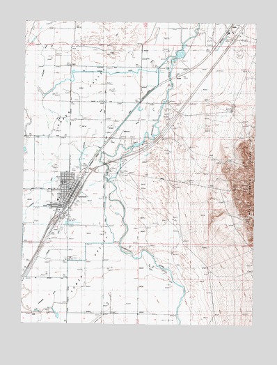
Lovelock, NV USGS Topographic Map
Click on map above to begin viewing in our Map Viewer.

This topographic map contains these locations and features:
Feature Name Type Latitude Longitude GNIS ID View Map
American CanalCanalN40.2060°W118.4538°838439View Map
Big Meadow RanchLocaleN40.1430°W118.4913°846204View Map
Circle L RanchLocaleN40.1516°W118.4757°863824View Map
City of LovelockCivilN40.1787°W118.4774°2410887View Map
ColadoPopulated PlaceN40.2455°W118.3929°855996View Map
Colado Mill DamDamN40.2449°W118.3893°863497View Map
Cold Canyon InterchangeCrossingN40.2435°W118.3965°846238View Map
East Lovelock InterchangeCrossingN40.1882°W118.4613°851979View Map
Fairview SloughCanalN40.1366°W118.4982°846205View Map
Graveyard DrainCanalN40.2119°W118.4971°840792View Map
Irish-American CanalCanalN40.1952°W118.4690°848688View Map
Irish-American DamDamN40.2176°W118.4242°846010View Map
Johnson DrainCanalN40.1752°W118.4938°841401View Map
KodakPopulated PlaceN40.2274°W118.4204°856062View Map
LovelockPopulated PlaceN40.1794°W118.4735°848577View Map
Lovelock Correctional CenterBuildingN40.2230°W118.3884°2740052View Map
Lovelock DrainCanalN40.2041°W118.4674°845890View Map
Lovelock Elementary SchoolSchoolN40.1835°W118.4785°846211View Map
Lovelock Indian ColonyCivilN40.1739°W118.4832°850417View Map
Lovelock Landing Strip (historical)AirportN40.1902°W118.4521°848245View Map
Lovelock Police DepartmentBuildingN40.1845°W118.4732°2740042View Map
Lovelock Post OfficePost OfficeN40.1806°W118.4753°864393View Map
Lovelock Volunteer Fire DepartmentBuildingN40.1816°W118.4731°2581259View Map
Lucky Lager RanchLocaleN40.2027°W118.4871°848444View Map
Main Street InterchangeCrossingN40.1782°W118.4707°851978View Map
Mineral Materials WellWellN40.2424°W118.3826°857055View Map
Munk RanchLocaleN40.2096°W118.4732°846203View Map
Nevada Highway Patrol Northern Command East Lovelock SubstationBuildingN40.1805°W118.4897°2740073View Map
Nevada Nile Copp RanchLocaleN40.1374°W118.4529°846202View Map
Old Channel CanalCanalN40.2257°W118.4771°848603View Map
Pallens Wells (historical)LocaleN40.1955°W118.4632°846348View Map
Pershing County Court HouseBuildingN40.1805°W118.4768°851976View Map
Pershing County High SchoolSchoolN40.1832°W118.4799°858340View Map
Pershing County Middle SchoolSchoolN40.1822°W118.4770°2079250View Map
Pershing County Sheriff's OfficeBuildingN40.1792°W118.4762°2740048View Map
Pershing General HospitalHospitalN40.1761°W118.4821°851977View Map
Pitt DamDamN40.2382°W118.4176°858140View Map
Reed DitchCanalN40.1410°W118.4663°846209View Map
Rodgers DamDamN40.1987°W118.4418°863328View Map
Rodgers DitchCanalN40.1657°W118.4649°846237View Map
Rudell DitchCanalN40.1985°W118.4538°846236View Map
Taylor CanalCanalN40.2441°W118.4938°844177View Map
Union CanalCanalN40.1541°W118.4549°852168View Map
Union CanalCanalN40.2046°W118.4515°846009View Map
Union Rodgers CanalCanalN40.1296°W118.4760°848687View Map
Upper ValleyValleyN40.1419°W118.4610°844553View Map
Upper Valley School (historical)SchoolN40.2171°W118.4590°852090View Map
West Lovelock InterchangeCrossingN40.1680°W118.4832°846208View Map
Willow SpringSpringN40.1869°W118.4699°852169View Map
Young CanalCanalN40.2432°W118.4301°845070View Map

Note: Coordinates in the location and feature list above are referenced to NAD83 datum.


Copyright (C) 2008-2025 Ryan Niemi / Sunset Dynamics ... All Rights Reserved