TopoQuest Logo
Do you find TopoQuest useful?
Help keep TopoQuest running and adding new maps/features by donating!
Bitcoin:  19c7KJd3qBynnjoSw5npx9KScwjBe4ifkT
Litecoin:  LXs6TkuXGGXo1vDsWCkWVdjQX94eUKd6ui
Home View Maps Find Maps Find Places Resources & Links


Luella, Georgia Topographic Map

USGS Map Title: Luella, GA
USGS Map MRC: 33084C2
DRG (GeoTIFF) Download: o33084c2.tif


Neighboring USGS Topographic Map Quads:


  Hampton, GA  
33084D3
 

  McDonough, GA  
33084D2
 

  Ola, GA  
33084D1
 

  Griffin North, GA  
33084C3
 

  Luella, GA  
33084C2
 

  Locust Grove, GA  
33084C1
 

  Griffin South, GA  
33084B3
 

  Orchard Hill, GA  
33084B2
 

  High Falls, GA  
33084B1


Map MRC Location:

N34°
W85°
N34°
W84°
H8 H7 H6 H5 H4 H3 H2 H1
G8 G7 G6 G5 G4 G3 G2 G1
F8 F7 F6 F5 F4 F3 F2 F1
E8 E7 E6 E5 E4 E3 E2 E1
D8 D7 D6 D5 D4 D3 D2 D1
C8 C7 C6 C5 C4 C3 C2 C1
B8 B7 B6 B5 B4 B3 B2 B1
A8 A7 A6 A5 A4 A3 A2 A1
N33°
W85°
N33°
W84°

Luella, GA USGS 1:24K Topographic Map Preview:
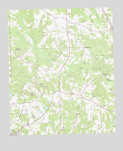
Luella, GA USGS Topographic Map
Click on map above to begin viewing in our Map Viewer.

This topographic map contains these locations and features:
Feature Name Type Latitude Longitude GNIS ID View Map
Barham CemeteryCemeteryN33.3418°W84.1777°310797View Map
Bostick CemeteryCemeteryN33.2912°W84.2108°311662View Map
Breed CemeteryCemeteryN33.2865°W84.1496°311747View Map
Cabin Creek Golf CourseLocaleN33.2743°W84.2327°352978View Map
Camp JacksonLocaleN33.2973°W84.2074°312233View Map
Chigger Hill AirportAirportN33.3169°W84.1502°2717249View Map
Christ our Savior Lutheran ChurchChurchN33.3136°W84.1975°2564997View Map
Dougherty LakeReservoirN33.2730°W84.2291°339376View Map
Dougherty Lake DamDamN33.2718°W84.2283°339375View Map
Dundee LakeReservoirN33.2951°W84.2483°338120View Map
Dundee Lake DamDamN33.2951°W84.2483°338119View Map
Ferguson CemeteryCemeteryN33.2771°W84.1657°355790View Map
Heron Bay Census Designated PlaceCensusN33.3393°W84.1921°2583405View Map
Heron Bay Golf & Country ClubLocaleN33.3377°W84.1999°2571210View Map
Holders Field (historical)AirportN33.3615°W84.1446°351828View Map
Horton LakeReservoirN33.2904°W84.2226°338106View Map
Horton Lake DamDamN33.2918°W84.2249°338105View Map
Hosama ChurchChurchN33.3259°W84.2263°315731View Map
Jackson Road Elementary SchoolSchoolN33.2557°W84.2399°353027View Map
Kennedy Road Middle SchoolSchoolN33.2665°W84.2352°2545719View Map
Long BranchStreamN33.3018°W84.1283°317314View Map
LuellaPopulated PlaceN33.3521°W84.1785°317476View Map
Luella Baptist ChurchChurchN33.3529°W84.1794°1671923View Map
Luella Middle SchoolSchoolN33.3740°W84.2038°2345628View Map
Mallards LandingAirportN33.3655°W84.1651°351827View Map
Manley CemeteryCemeteryN33.3004°W84.1888°317656View Map
McDonough Road Baptist ChurchChurchN33.2837°W84.1905°353032View Map
Mill CreekStreamN33.3440°W84.2177°318203View Map
Mize LakeReservoirN33.2775°W84.2067°338116View Map
Mize Lake DamDamN33.2751°W84.2049°338115View Map
Mount Calvary ChurchChurchN33.3329°W84.2488°353033View Map
Parham CemeteryCemeteryN33.2837°W84.1513°320198View Map
Parks LakeReservoirN33.2701°W84.2499°338112View Map
Parks Lake DamDamN33.2701°W84.2499°338111View Map
Pleasant GrovePopulated PlaceN33.2896°W84.1758°353043View Map
Pleasant Grove ChurchChurchN33.2904°W84.1760°320829View Map
Pullin CemeteryCemeteryN33.3601°W84.1716°321223View Map
Regents LakeReservoirN33.2897°W84.1922°339892View Map
Regents Lake DamDamN33.2884°W84.1916°339891View Map
Ringgold ChurchChurchN33.2857°W84.1633°321616View Map
Shappard LakeReservoirN33.2727°W84.2114°339374View Map
Shappard Lake DamDamN33.2718°W84.2116°339373View Map
Sharon Baptist ChurchChurchN33.2507°W84.2433°353054View Map
Slayton CemeteryCemeteryN33.3129°W84.2050°323079View Map
Spalding County Fire Department Station 3BuildingN33.2901°W84.1760°2604431View Map
Steeles MillPopulated PlaceN33.3076°W84.1369°330991View Map
Strong Rock Christian SchoolSchoolN33.3423°W84.1320°2546200View Map
Teamon ChurchChurchN33.3162°W84.2163°323970View Map
Thompson CreekStreamN33.3346°W84.2155°324115View Map
TowalagaPopulated PlaceN33.3143°W84.2046°333249View Map
Towalaga DivisionCivilN33.2961°W84.1760°1936499View Map
Troublesome CreekStreamN33.3126°W84.1760°324330View Map
Union ChurchChurchN33.2765°W84.1410°324529View Map
Upper Towaliga ReservoirReservoirN33.3251°W84.2048°2571264View Map
Walker MillPopulated PlaceN33.2707°W84.1716°333345View Map
Williams LakeReservoirN33.2575°W84.1964°339378View Map
Williams Lake DamDamN33.2584°W84.1966°339377View Map
Wolf Creek Baptist ChurchChurchN33.3034°W84.2183°353076View Map

Note: Coordinates in the location and feature list above are referenced to NAD83 datum.


Copyright (C) 2008-2024 Ryan Niemi / Sunset Dynamics ... All Rights Reserved