TopoQuest Logo
Do you find TopoQuest useful?
Help keep TopoQuest running and adding new maps/features by donating!
Bitcoin:  19c7KJd3qBynnjoSw5npx9KScwjBe4ifkT
Litecoin:  LXs6TkuXGGXo1vDsWCkWVdjQX94eUKd6ui
Home View Maps Find Maps Find Places Resources & Links


Lyon Manor, Michigan Topographic Map

USGS Map Title: Lyon Manor, MI
USGS Map MRC: 44084D6
DRG (GeoTIFF) Download: o44084d6.tif


Neighboring USGS Topographic Map Quads:


  Cote Dame Marie, MI  
44084E7
 

  Pere Cheney, MI  
44084E6
 

  Roscommon North, MI  
44084E5


  Lyon Manor, MI  
44084D6
 

  Roscommon South, MI  
44084D5


  Prudenville, MI  
44084C6
 

  Backus Lake, MI  
44084C5


Map MRC Location:

N45°
W85°
N45°
W84°
H8 H7 H6 H5 H4 H3 H2 H1
G8 G7 G6 G5 G4 G3 G2 G1
F8 F7 F6 F5 F4 F3 F2 F1
E8 E7 E6 E5 E4 E3 E2 E1
D8 D7 D6 D5 D4 D3 D2 D1
C8 C7 C6 C5 C4 C3 C2 C1
B8 B7 B6 B5 B4 B3 B2 B1
A8 A7 A6 A5 A4 A3 A2 A1
N44°
W85°
N44°
W84°

Lyon Manor, MI USGS 1:24K Topographic Map Preview:
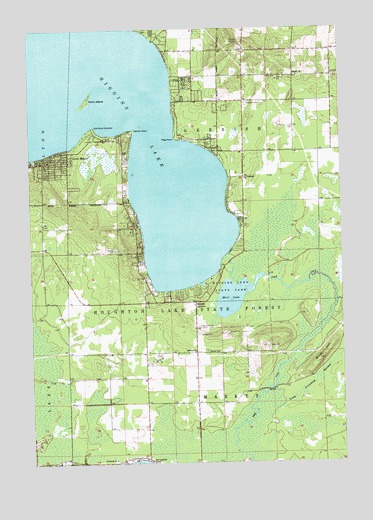
Lyon Manor, MI USGS Topographic Map
Click on map above to begin viewing in our Map Viewer.

This topographic map contains these locations and features:
Feature Name Type Latitude Longitude GNIS ID View Map
Birch HillSummitN44.4050°W84.6347°621402View Map
Burning Oak Country ClubLocaleN44.3964°W84.6789°2509020View Map
Church of Jesus Christ of Latter Day SaintsChurchN44.4069°W84.7142°2509019View Map
Detroit PointCapeN44.4711°W84.7072°624585View Map
Flag PointCapeN44.4689°W84.6906°626130View Map
Flynn IslandIslandN44.4797°W84.7259°626203View Map
Gerrish Historical MarkerParkN44.4575°W84.6644°2509037View Map
Gerrish Township CemeteryCemeteryN44.4786°W84.6625°2509034View Map
Gerrish Township Fire and Emergency Medical Services HeadquartersBuildingN44.4578°W84.6644°2626979View Map
Gerrish Township Fire and Emergency Medical Services Station 2BuildingN44.4216°W84.6823°2626897View Map
Gerrish Township Fire and Emergency Medical Services Station 3BuildingN44.4354°W84.7069°2626896View Map
Gerrish Township Police DepartmentBuildingN44.4587°W84.6645°2737539View Map
Good Shepherd United Methodist ChurchChurchN44.4647°W84.6286°2508901View Map
Great Circle CampgroundLocaleN44.4211°W84.7233°2508891View Map
Higgins LakeLakeN44.4743°W84.7227°628219View Map
Higgins Lake CampgroundLocaleN44.4803°W84.6261°2509028View Map
Higgins Lake Hideaway Mobile Home ParkPopulated PlaceN44.4614°W84.7458°2509024View Map
Immanuel Baptist ChurchChurchN44.4861°W84.6667°2508903View Map
Immanuel Baptist SchoolSchoolN44.4861°W84.6667°2508902View Map
Lyon ManorPopulated PlaceN44.4614°W84.7439°631243View Map
Markey CemeteryCemeteryN44.4072°W84.6795°631576View Map
Markey ChurchChurchN44.4070°W84.6834°631577View Map
Markey Post Office (historical)Post OfficeN44.3806°W84.6833°2508854View Map
Marl LakeLakeN44.4228°W84.6692°631591View Map
Messiah ChurchChurchN44.4864°W84.6431°632160View Map
North Shore Trailer ParkPopulated PlaceN44.3756°W84.7317°2508999View Map
Old Point ComfortCapeN44.4714°W84.7228°634012View Map
Pioneer Ski HillSummitN44.4970°W84.6684°635034View Map
Saint Elizabeth ChurchChurchN44.4572°W84.6628°636628View Map
Saint James ChurchChurchN44.3759°W84.7167°636686View Map
Sharps CornersPopulated PlaceN44.4211°W84.6836°637675View Map
South Higgins Lake State ParkParkN44.4259°W84.6689°628221View Map
South Higgins Lake State Park East CampgroundLocaleN44.4244°W84.6833°2508911View Map
South Higgns Lake State Park West CampgroundLocaleN44.4233°W84.6900°2508910View Map
Township of GerrishCivilN44.4663°W84.6733°1626348View Map
Township of MarkeyCivilN44.3779°W84.6740°1626693View Map
Ye Olde Country ClubLocaleN44.4972°W84.6278°2509027View Map

Note: Coordinates in the location and feature list above are referenced to NAD83 datum.


Copyright (C) 2008-2024 Ryan Niemi / Sunset Dynamics ... All Rights Reserved