TopoQuest Logo
Do you find TopoQuest useful?
Help keep TopoQuest running and adding new maps/features by donating!
Bitcoin:  19c7KJd3qBynnjoSw5npx9KScwjBe4ifkT
Litecoin:  LXs6TkuXGGXo1vDsWCkWVdjQX94eUKd6ui
Home View Maps Find Maps Find Places Resources & Links


Prudenville, Michigan Topographic Map

USGS Map Title: Prudenville, MI
USGS Map MRC: 44084C6
DRG (GeoTIFF) Download: o44084c6.tif


Neighboring USGS Topographic Map Quads:


  Lyon Manor, MI  
44084D6
 

  Roscommon South, MI  
44084D5


  Prudenville, MI  
44084C6
 

  Backus Lake, MI  
44084C5


  Meredith NW, MI  
44084B6
 

  Meredith, MI  
44084B5


Map MRC Location:

N45°
W85°
N45°
W84°
H8 H7 H6 H5 H4 H3 H2 H1
G8 G7 G6 G5 G4 G3 G2 G1
F8 F7 F6 F5 F4 F3 F2 F1
E8 E7 E6 E5 E4 E3 E2 E1
D8 D7 D6 D5 D4 D3 D2 D1
C8 C7 C6 C5 C4 C3 C2 C1
B8 B7 B6 B5 B4 B3 B2 B1
A8 A7 A6 A5 A4 A3 A2 A1
N44°
W85°
N44°
W84°

Prudenville, MI USGS 1:24K Topographic Map Preview:
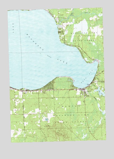
Prudenville, MI USGS Topographic Map
Click on map above to begin viewing in our Map Viewer.

This topographic map contains these locations and features:
Feature Name Type Latitude Longitude GNIS ID View Map
Abundant Grace Assembly of God ChurchChurchN44.3056°W84.6319°2508989View Map
Backus CreekStreamN44.3597°W84.6856°620411View Map
Camp Co Be AcLocaleN44.2642°W84.7009°622550View Map
Collins Elementary SchoolSchoolN44.2972°W84.7300°2509012View Map
Denton CreekStreamN44.3025°W84.6453°624559View Map
Denton ParkParkN44.2939°W84.6536°624567View Map
Denton Township Ambulance ServiceBuildingN44.3052°W84.6379°2661961View Map
Denton Township Fire DepartmentBuildingN44.2973°W84.6524°2626875View Map
Denton Township Police DepartmentBuildingN44.2974°W84.6514°2737587View Map
Denton Township Trailer ParkPopulated PlaceN44.2944°W84.6533°2508995View Map
East BayBayN44.3111°W84.6472°625112View Map
East Bay Medical CenterHospitalN44.3147°W84.6278°2508988View Map
Emery HillSummitN44.2600°W84.6875°625575View Map
First Baptist ChurchChurchN44.2989°W84.6683°2508993View Map
Houghton LakeLakeN44.3370°W84.7216°628664View Map
Houghton Lake Area Historical VillageLocaleN44.2981°W84.6708°2508994View Map
Houghton Lake High SchoolSchoolN44.2972°W84.7284°628667View Map
Houghton Lake Middle SchoolSchoolN44.2972°W84.7292°2509011View Map
Jehovah's Witnesses HallChurchN44.3028°W84.6444°2508996View Map
Knappen CreekStreamN44.3003°W84.6511°629807View Map
Lake Co-Be-AcLakeN44.2708°W84.7027°634248View Map
Markey ParkParkN44.3542°W84.6772°631578View Map
Markey Township Fire and Emergency Medical Services DepartmentBuildingN44.3650°W84.6838°2626878View Map
Markey Township HallBuildingN44.3553°W84.6769°2509002View Map
Mercy Family CareHospitalN44.2992°W84.6931°2508914View Map
North Shore SchoolSchoolN44.3692°W84.6828°633654View Map
Our Lady of the Lake Catholic ChurchChurchN44.2978°W84.6575°2508991View Map
Our Lady of the Lake SchoolSchoolN44.2978°W84.6575°2508992View Map
Pathway Southern Baptist ChurchChurchN44.2911°W84.6569°2508990View Map
Pineview Highlands Golf CourseLocaleN44.2947°W84.7361°2509022View Map
PrudenvillePopulated PlaceN44.2984°W84.6520°635500View Map
Prudenville CemeteryCemeteryN44.2908°W84.6925°2509033View Map
Prudenville Census Designated PlaceCensusN44.3015°W84.6652°2393199View Map
Prudenville Elementary SchoolSchoolN44.2942°W84.6556°2509013View Map
Prudenville Post OfficePost OfficeN44.2986°W84.6536°2508913View Map
Roscommon County - Blodgett Memorial AirportAirportN44.3590°W84.6772°1623966View Map
Saint Johns Lutheran ChurchChurchN44.2989°W84.6964°2509021View Map
Sandyoak RV ParkLocaleN44.2789°W84.6889°2508998View Map
Songers PointCapeN44.3458°W84.6831°2508906View Map
Spring BrookStreamN44.3106°W84.6378°638545View Map
The CutStreamN44.3689°W84.6650°1614709View Map
Township of DentonCivilN44.2912°W84.6724°1626177View Map
WHGR-AM (Houghton Lake)TowerN44.2975°W84.7072°1625226View Map
WHGR-AM (Houghton Lake)TowerN44.2861°W84.7439°1625228View Map
White Deer Country ClubLocaleN44.2950°W84.6622°2508997View Map
WUPS-FM (Houghton Lake)TowerN44.2884°W84.7417°1625419View Map

Note: Coordinates in the location and feature list above are referenced to NAD83 datum.


Copyright (C) 2008-2025 Ryan Niemi / Sunset Dynamics ... All Rights Reserved