TopoQuest Logo
Do you find TopoQuest useful?
Help keep TopoQuest running and adding new maps/features by donating!
Bitcoin:  19c7KJd3qBynnjoSw5npx9KScwjBe4ifkT
Litecoin:  LXs6TkuXGGXo1vDsWCkWVdjQX94eUKd6ui
Home View Maps Find Maps Find Places Resources & Links


Macedon, New York Topographic Map

USGS Map Title: Macedon, NY
USGS Map MRC: 43077A3
DRG (GeoTIFF) Download: o43077a3.tif


Neighboring USGS Topographic Map Quads:


  Webster, NY  
43077B4
 

  Ontario, NY  
43077B3
 

  Williamson, NY  
43077B2
 

  Fairport, NY  
43077A4
 

  Macedon, NY  
43077A3
 

  Palmyra, NY  
43077A2
 

  Victor, NY  
42077H4
 

  Canandaigua, NY  
42077H3
 

  Clifton Springs, NY  
42077H2


Map MRC Location:

N44°
W78°
N44°
W77°
H8 H7 H6 H5 H4 H3 H2 H1
G8 G7 G6 G5 G4 G3 G2 G1
F8 F7 F6 F5 F4 F3 F2 F1
E8 E7 E6 E5 E4 E3 E2 E1
D8 D7 D6 D5 D4 D3 D2 D1
C8 C7 C6 C5 C4 C3 C2 C1
B8 B7 B6 B5 B4 B3 B2 B1
A8 A7 A6 A5 A4 A3 A2 A1
N43°
W78°
N43°
W77°

Macedon, NY USGS 1:24K Topographic Map Preview:
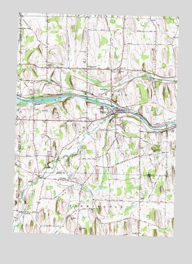
Macedon, NY USGS Topographic Map
Click on map above to begin viewing in our Map Viewer.

This topographic map contains these locations and features:
Feature Name Type Latitude Longitude GNIS ID View Map
Amans NurseryLocaleN43.0375°W77.2764°2547335View Map
Arrowhead Mobile Home ParkPopulated PlaceN43.0947°W77.3503°2493986View Map
Bickford Home for the AgedBuildingN43.0687°W77.3024°2599558View Map
Black CreekStreamN43.1245°W77.2697°944113View Map
BrownsvillePopulated PlaceN43.0117°W77.3664°944964View Map
Calvary Chapel of MacedonChurchN43.0679°W77.3619°2598194View Map
Canandaigua Road BridgeBridgeN43.0770°W77.3205°2599563View Map
Cator CornersPopulated PlaceN43.0940°W77.3019°946058View Map
Crooked Pines Golf ClubLocaleN43.0505°W77.3554°2599579View Map
Dynamite HillSummitN43.0031°W77.3228°948900View Map
FarmingtonPopulated PlaceN43.0320°W77.3322°949920View Map
Farmington Friends ChurchChurchN43.0283°W77.3208°2364572View Map
First Baptist Church of MacedonChurchN43.0685°W77.3019°2417987View Map
Gananda - R Mann Elementary SchoolSchoolN43.1208°W77.3109°2598178View Map
Gananda Community ChurchChurchN43.1225°W77.3217°2598209View Map
Gananda R A Cirillo High SchoolSchoolN43.1200°W77.3077°2598185View Map
Goat Bridge FarmLocaleN43.1036°W77.2908°2560402View Map
Harvs AirportAirportN43.1191°W77.3682°2770580View Map
Hillcrest Trailer CourtPopulated PlaceN43.0847°W77.3506°2493984View Map
HuddlePopulated PlaceN43.1226°W77.2719°953380View Map
Lakestone Farm AirportAirportN43.0344°W77.3076°978127View Map
Lock Number 30DamN43.0734°W77.3011°974722View Map
Long Acre FarmLocaleN43.1147°W77.3142°2547483View Map
Long Acre Farms AirportAirportN43.1132°W77.3151°2443552View Map
MacedonPopulated PlaceN43.0692°W77.2989°956224View Map
Macedon Census Designated PlaceCensusN43.0683°W77.3036°2791459View Map
Macedon CenterPopulated PlaceN43.0942°W77.3205°956225View Map
Macedon Center CemeteryCemeteryN43.1039°W77.3213°956226View Map
Macedon Center United Methodist ChurchChurchN43.0939°W77.3222°2417993View Map
Macedon Elementary SchoolSchoolN43.0683°W77.3044°2417985View Map
Macedon Fire DepartmentBuildingN43.0961°W77.3210°2700791View Map
Macedon Fire DepartmentBuildingN43.0683°W77.3003°2417990View Map
Macedon Industrial ParkLocaleN43.0668°W77.3254°2599607View Map
Macedon Post OfficePost OfficeN43.0621°W77.3203°2599541View Map
Macedon Public LibraryBuildingN43.0668°W77.3073°2599588View Map
Macedon Town HallBuildingN43.0669°W77.3067°2599598View Map
Macedon Village CemeteryCemeteryN43.0683°W77.3005°2417994View Map
Macedon Village HallBuildingN43.0685°W77.3003°2599599View Map
Maiers Mud AcresLocaleN43.0472°W77.3092°2547484View Map
New Salem AerodromeAirportN43.0063°W77.2908°2443121View Map
North Farmington Friends CemeteryCemeteryN43.0284°W77.3195°2542259View Map
North MacedonPopulated PlaceN43.0823°W77.3044°972869View Map
North Wayneport Road BridgeBridgeN43.0752°W77.3613°2599569View Map
Perinton Golf ClubLocaleN43.1005°W77.3728°2615452View Map
Quaker Road BridgeBridgeN43.0711°W77.2894°2599571View Map
Research Forest Industrial ParkLocaleN43.1199°W77.3179°2599609View Map
Saint Patrick's Catholic ChurchChurchN43.0697°W77.2978°2417991View Map
Saint Patricks CemeteryCemeteryN43.0763°W77.2997°964066View Map
Salem CemeteryCemeteryN43.0317°W77.3290°964293View Map
School Number 1 (historical)SchoolN43.0498°W77.2780°974913View Map
School Number 11 (historical)SchoolN43.0212°W77.2767°974996View Map
School Number 12 (historical)SchoolN43.0323°W77.3308°975037View Map
School Number 2 (historical)SchoolN43.0908°W77.2656°2380746View Map
School Number 3 (historical)SchoolN43.1164°W77.3003°2380747View Map
School Number 4 (historical)SchoolN43.0640°W77.3511°975366View Map
School Number 5 (historical)SchoolN43.0603°W77.3200°975433View Map
School Number 6 (historical)SchoolN43.0650°W77.2592°2380748View Map
School Number 7 (historical)SchoolN43.0389°W77.3056°2380749View Map
School Number 9 (historical)SchoolN43.0976°W77.3211°975653View Map
Science HillSummitN43.0928°W77.2955°964647View Map
Science Hill SchoolSchoolN43.0945°W77.2964°964648View Map
Scribner HillSummitN43.0095°W77.3300°964707View Map
Sheldon FarmLocaleN43.0064°W77.3047°2558864View Map
Tannery SchoolSchoolN43.0953°W77.3514°967055View Map
Town of MacedonCivilN43.0792°W77.3095°979179View Map
Trap BrookStreamN43.0645°W77.3033°967757View Map
Union Burying GroundCemeteryN43.0853°W77.3620°968165View Map
Universalist ChurchChurchN43.0697°W77.3008°2417988View Map
Village of Macedon (historical)CivilN43.0683°W77.3036°2390955View Map
Walworth Road BridgeBridgeN43.0637°W77.2581°2599573View Map
Walworth StationLocaleN43.0892°W77.2692°968749View Map
WayneportPopulated PlaceN43.0728°W77.3611°968956View Map
WZXV-FM (Palmyra)TowerN43.1040°W77.3453°978579View Map
Yellow MillsPopulated PlaceN43.0606°W77.2569°971822View Map

Note: Coordinates in the location and feature list above are referenced to NAD83 datum.


Copyright (C) 2008-2025 Ryan Niemi / Sunset Dynamics ... All Rights Reserved