TopoQuest Logo
Do you find TopoQuest useful?
Help keep TopoQuest running and adding new maps/features by donating!
Bitcoin:  19c7KJd3qBynnjoSw5npx9KScwjBe4ifkT
Litecoin:  LXs6TkuXGGXo1vDsWCkWVdjQX94eUKd6ui
Home View Maps Find Maps Find Places Resources & Links


Bayard, Nebraska Topographic Map

USGS Map Title: Bayard, NE
USGS Map MRC: 41103G3
DRG (GeoTIFF) Download: o41103g3.tif


Neighboring USGS Topographic Map Quads:


  Lake Minatare, NE  
41103H4
 

  Bayard NE, NE  
41103H3
 

  Angora NW, NE  
41103H2
 

  Bayard SW, NE  
41103G4
 

  Bayard, NE  
41103G3
 

  Angora, NE  
41103G2
 

  McGrew, NE  
41103F4
 

  South Bayard, NE  
41103F3
 

  Bridgeport NW, NE  
41103F2


Map MRC Location:

N42°
W104°
N42°
W103°
H8 H7 H6 H5 H4 H3 H2 H1
G8 G7 G6 G5 G4 G3 G2 G1
F8 F7 F6 F5 F4 F3 F2 F1
E8 E7 E6 E5 E4 E3 E2 E1
D8 D7 D6 D5 D4 D3 D2 D1
C8 C7 C6 C5 C4 C3 C2 C1
B8 B7 B6 B5 B4 B3 B2 B1
A8 A7 A6 A5 A4 A3 A2 A1
N41°
W104°
N41°
W103°

Bayard, NE USGS 1:24K Topographic Map Preview:
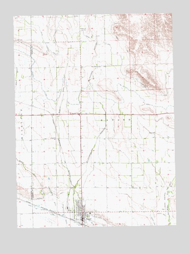
Bayard, NE USGS Topographic Map
Click on map above to begin viewing in our Map Viewer.

This topographic map contains these locations and features:
Feature Name Type Latitude Longitude GNIS ID View Map
Assembly of God ChurchChurchN41.7552°W103.3222°1829904View Map
Assumption Greek Orthodox ChurchChurchN41.7589°W103.3222°1829910View Map
BayardPopulated PlaceN41.7550°W103.3241°827222View Map
BayardLocaleN41.7550°W103.3241°1829924View Map
Bayard Chimney Rock MuseumBuildingN41.7516°W103.3255°1829997View Map
Bayard ClinicHospitalN41.7639°W103.3222°1829914View Map
Bayard Elementary SchoolSchoolN41.7580°W103.3180°1829919View Map
Bayard Fire and RescueBuildingN41.7556°W103.3238°2553373View Map
Bayard Memorial ChapelChurchN41.7550°W103.3241°1829913View Map
Bayard Police DepartmentBuildingN41.7542°W103.3245°1829922View Map
Bayard Post OfficePost OfficeN41.7559°W103.3245°1829917View Map
Bayard Public LibraryBuildingN41.7561°W103.3255°1829916View Map
Bayard Secondary SchoolSchoolN41.7580°W103.3180°1829903View Map
Chimney Rock ClinicHospitalN41.7550°W103.3241°1829923View Map
Chimney Rock Golf CourseLocaleN41.7755°W103.3338°1829994View Map
Chimney Rock Medical CenterHospitalN41.7539°W103.3238°1829918View Map
Chimney Rock Villa HomeHospitalN41.7639°W103.3222°1829915View Map
Church of ChristChurchN41.7661°W103.3277°1829908View Map
Church of ChristChurchN41.8441°W103.3072°828138View Map
City of BayardCivilN41.7572°W103.3230°2394089View Map
Community Bible ChurchChurchN41.7602°W103.3238°1829909View Map
CraftPopulated PlaceN41.8158°W103.3463°835279View Map
Davidson DamDamN41.8683°W103.2905°1769020View Map
Davidson ReservoirReservoirN41.8683°W103.2905°1769021View Map
East Bayard Election PrecinctCivilN41.7836°W103.2619°1928832View Map
Hope Congregational ChurchChurchN41.7550°W103.3241°1829912View Map
Kelley Bean Company Incorporated ElevatorLocaleN41.7550°W103.3241°1829921View Map
Lowline CanalCanalN41.8386°W103.2874°830948View Map
Moomaw CornerPopulated PlaceN41.8166°W103.3238°831391View Map
Mount Calvary Lutheran ChurchChurchN41.7639°W103.3258°1829911View Map
Ninemile CanalCanalN41.7666°W103.3608°831630View Map
PiperPopulated PlaceN41.7597°W103.2585°835412View Map
Sacred Heart Catholic ChurchChurchN41.7552°W103.3224°1829907View Map
School Number 61SchoolN41.8027°W103.3441°836949View Map
School Number 73SchoolN41.8047°W103.2660°837055View Map
School Number 96SchoolN41.7725°W103.2841°837208View Map
Short Line CanalCanalN41.7625°W103.3622°833415View Map
Stuckenhole DrainStreamN41.7591°W103.3447°833870View Map
Trinidad Bean and Elevator Company ElevatorLocaleN41.7550°W103.3241°1829920View Map
United Church of ChristChurchN41.7644°W103.3235°1829906View Map
United Methodist ChurchChurchN41.7577°W103.3238°1829905View Map
Wildhorse CanyonValleyN41.7858°W103.3202°834733View Map
Wildhorse ChurchChurchN41.8669°W103.3224°834735View Map
Wildhorse Dam 14-ADamN41.8200°W103.3405°1768015View Map
Wildhorse Dam 5-ADamN41.7900°W103.3188°1768013View Map
Wildhorse Reservoir 14-AReservoirN41.8200°W103.3405°1768016View Map
Wildhorse Reservoir 5-AReservoirN41.7900°W103.3188°1768014View Map

Note: Coordinates in the location and feature list above are referenced to NAD83 datum.


Copyright (C) 2008-2025 Ryan Niemi / Sunset Dynamics ... All Rights Reserved