TopoQuest Logo
Do you find TopoQuest useful?
Help keep TopoQuest running and adding new maps/features by donating!
Bitcoin:  19c7KJd3qBynnjoSw5npx9KScwjBe4ifkT
Litecoin:  LXs6TkuXGGXo1vDsWCkWVdjQX94eUKd6ui
Home View Maps Find Maps Find Places Resources & Links


Malaga, New Mexico Topographic Map

USGS Map Title: Malaga, NM
USGS Map MRC: 32104B1
DRG (GeoTIFF) Download: o32104b1.tif


Neighboring USGS Topographic Map Quads:


  Otis, NM  
32104C2
 

  Loving, NM  
32104C1
 

  Remuda Basin, NM  
32103C8
 

  Bond Draw, NM  
32104B2
 

  Malaga, NM  
32104B1
 

  Pierce Canyon, NM  
32103B8
 

  Cottonwood Hills, NM  
32104A2
 

  Red Bluff, NM  
32104A1
 

  Ross Ranch, NM  
32103A8


Map MRC Location:

N33°
W105°
N33°
W104°
H8 H7 H6 H5 H4 H3 H2 H1
G8 G7 G6 G5 G4 G3 G2 G1
F8 F7 F6 F5 F4 F3 F2 F1
E8 E7 E6 E5 E4 E3 E2 E1
D8 D7 D6 D5 D4 D3 D2 D1
C8 C7 C6 C5 C4 C3 C2 C1
B8 B7 B6 B5 B4 B3 B2 B1
A8 A7 A6 A5 A4 A3 A2 A1
N32°
W105°
N32°
W104°

Malaga, NM USGS 1:24K Topographic Map Preview:
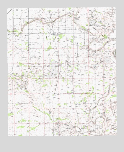
Malaga, NM USGS Topographic Map
Click on map above to begin viewing in our Map Viewer.

This topographic map contains these locations and features:
Feature Name Type Latitude Longitude GNIS ID View Map
Black RiverStreamN32.2418°W104.0466°903894View Map
China DrawValleyN32.1701°W104.1116°887541View Map
Chinaberry WellWellN32.1660°W104.0694°887551View Map
Cleveland RanchLocaleN32.1940°W104.0438°887684View Map
Donaldson WellWellN32.1976°W104.0888°888454View Map
Espejos Trail Historical MarkerParkN32.2240°W104.0724°931711View Map
Harroun CrossingPopulated PlaceN32.2407°W104.0485°899666View Map
Harroun Lake DamDamN32.2318°W104.0288°923947View Map
Horseshoe LakeLakeN32.1734°W104.1078°898334View Map
Kelly WellWellN32.1871°W104.1247°890657View Map
Lookout (historical)Populated PlaceN32.2323°W104.1124°931284View Map
Lookout CemeteryCemeteryN32.2315°W104.1094°938554View Map
Lookout CrossingPopulated PlaceN32.2254°W104.1191°899734View Map
MalagaPopulated PlaceN32.2240°W104.0724°891551View Map
Malaga Census Designated PlaceCensusN32.2227°W104.0692°2584152View Map
Malaga Post OfficePost OfficeN32.2248°W104.0725°938221View Map
Malaga Volunteer Fire and RescueBuildingN32.2259°W104.0730°2657830View Map
Mexican LakeLakeN32.1771°W104.1038°901180View Map
Plowman RanchLocaleN32.2112°W104.1016°893365View Map
Queen LakeLakeN32.1908°W104.0230°893583View Map
Reed RanchLocaleN32.1957°W104.0569°893846View Map
Salt DrawValleyN32.1307°W104.0427°894344View Map
Salt Draw WellWellN32.1373°W104.0585°894346View Map
South Donaldson WellWellN32.1732°W104.0919°895036View Map
South Reed WellWellN32.1757°W104.0491°895115View Map
Willow Creek DitchStreamN32.2079°W104.0680°900871View Map
Willow LakeReservoirN32.1893°W104.0731°923974View Map
Willow Lake DamDamN32.1968°W104.0705°923973View Map

Note: Coordinates in the location and feature list above are referenced to NAD83 datum.


Copyright (C) 2008-2025 Ryan Niemi / Sunset Dynamics ... All Rights Reserved