TopoQuest Logo
Do you find TopoQuest useful?
Help keep TopoQuest running and adding new maps/features by donating!
Bitcoin:  19c7KJd3qBynnjoSw5npx9KScwjBe4ifkT
Litecoin:  LXs6TkuXGGXo1vDsWCkWVdjQX94eUKd6ui
Home View Maps Find Maps Find Places Resources & Links


Mallo Pass Creek, California Topographic Map

USGS Map Title: Mallo Pass Creek, CA
USGS Map MRC: 39123A6
DRG (GeoTIFF) Download: o39123a6.tif


Neighboring USGS Topographic Map Quads:


  Albion, CA  
39123B7
 

  Elk, CA  
39123B6
 

  Navarro, CA  
39123B5


  Mallo Pass Creek, CA  
39123A6
 

  Cold Spring, CA  
39123A5


  Point Arena, CA  
38123H6
 

  Eureka Hill, CA  
38123H5


Map MRC Location:

N40°
W124°
N40°
W123°
H8 H7 H6 H5 H4 H3 H2 H1
G8 G7 G6 G5 G4 G3 G2 G1
F8 F7 F6 F5 F4 F3 F2 F1
E8 E7 E6 E5 E4 E3 E2 E1
D8 D7 D6 D5 D4 D3 D2 D1
C8 C7 C6 C5 C4 C3 C2 C1
B8 B7 B6 B5 B4 B3 B2 B1
A8 A7 A6 A5 A4 A3 A2 A1
N39°
W124°
N39°
W123°

Mallo Pass Creek, CA USGS 1:24K Topographic Map Preview:
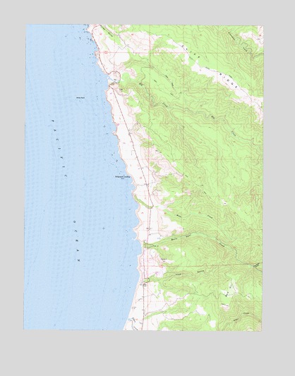
Mallo Pass Creek, CA USGS Topographic Map
Click on map above to begin viewing in our Map Viewer.

This topographic map contains these locations and features:
Feature Name Type Latitude Longitude GNIS ID View Map
Alder CreekStreamN39.0046°W123.6967°218098View Map
Bald HillSummitN39.0107°W123.6453°218570View Map
Bridgeport LandingLocaleN39.0627°W123.6950°1658135View Map
Bridgeport School (historical)SchoolN39.0521°W123.6842°1652993View Map
Christiansen RanchLocaleN39.0605°W123.6842°1653006View Map
Cliff RidgeRidgeN39.0916°W123.6283°255080View Map
Cowshed GulchValleyN39.0263°W123.6308°221719View Map
Elk CreekStreamN39.1021°W123.7075°223109View Map
Elk RockIslandN39.1091°W123.7156°254354View Map
Elk Volunteer Fire Department Station 714BuildingN39.0590°W123.6855°2622210View Map
Galletti RanchLocaleN39.0807°W123.6958°1653033View Map
Irish Beach Water District Volunteer Fire DepartmentBuildingN39.0219°W123.6783°2621993View Map
Irish CreekStreamN39.0202°W123.6911°1653050View Map
Irish GulchValleyN39.0207°W123.6800°225969View Map
Mallo Pass CreekStreamN39.0341°W123.6895°227983View Map
Mills CreekStreamN39.0555°W123.6945°228768View Map
San Andreas FaultValleyN39.0039°W123.6967°234619View Map
White RockIslandN39.0949°W123.7192°237657View Map

Note: Coordinates in the location and feature list above are referenced to NAD83 datum.


Copyright (C) 2008-2024 Ryan Niemi / Sunset Dynamics ... All Rights Reserved