TopoQuest Logo
Do you find TopoQuest useful?
Help keep TopoQuest running and adding new maps/features by donating!
Bitcoin:  19c7KJd3qBynnjoSw5npx9KScwjBe4ifkT
Litecoin:  LXs6TkuXGGXo1vDsWCkWVdjQX94eUKd6ui
Home View Maps Find Maps Find Places Resources & Links


Manteo, North Carolina Topographic Map

USGS Map Title: Manteo, NC
USGS Map MRC: 35075H6
DRG (GeoTIFF) Download: o35075h6.tif


Neighboring USGS Topographic Map Quads:


  Point Harbor, NC  
36075A7


  Manns Harbor, NC  
35075H7
 

  Manteo, NC  
35075H6
 

  Roanoke Island NE, NC  
35075H5
 

  East Lake SE, NC  
35075G7
 

  Wanchese, NC  
35075G6
 

  Oregon Inlet, NC  
35075G5


Map MRC Location:

N36°
W76°
N36°
W75°
H8 H7 H6 H5 H4 H3 H2 H1
G8 G7 G6 G5 G4 G3 G2 G1
F8 F7 F6 F5 F4 F3 F2 F1
E8 E7 E6 E5 E4 E3 E2 E1
D8 D7 D6 D5 D4 D3 D2 D1
C8 C7 C6 C5 C4 C3 C2 C1
B8 B7 B6 B5 B4 B3 B2 B1
A8 A7 A6 A5 A4 A3 A2 A1
N35°
W76°
N35°
W75°

Manteo, NC USGS 1:24K Topographic Map Preview:
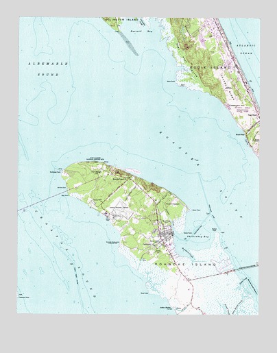
Manteo, NC USGS Topographic Map
Click on map above to begin viewing in our Map Viewer.

This topographic map contains these locations and features:
Feature Name Type Latitude Longitude GNIS ID View Map
Ananias Dare Street BridgeBridgeN35.9121°W75.6693°1024916View Map
Ashbee HarborBayN35.8791°W75.6721°980315View Map
Ballast PointCapeN35.9102°W75.6477°980499View Map
Baum PointCapeN35.9193°W75.6599°980638View Map
Bens PointCapeN35.9938°W75.6977°1002389View Map
Black Hall BayBayN35.9066°W75.7071°1018659View Map
Blockade ShoalBarN35.9252°W75.7302°1002390View Map
Britthaven of Outer BanksBuildingN35.9783°W75.6490°2505746View Map
Burnside Headquarters (historical)LocaleN35.9054°W75.6968°982291View Map
Buzzard BayBayN35.9946°W75.6846°982346View Map
Buzzard PointCapeN35.9966°W75.6774°1002391View Map
CaliforniaPopulated PlaceN35.9043°W75.6805°1019473View Map
Cape Hatteras Group HeadquartersParkN35.9363°W75.7102°1001111View Map
Colington CutGutN35.9960°W75.6982°1004654View Map
Colington Island ShoalBarN35.9752°W75.7246°1002392View Map
Crab Claw SpitCapeN35.9382°W75.6982°1002384View Map
Crime LineBuildingN35.9173°W75.6876°2130964View Map
Dare County Emergency Medical Services Station 2BuildingN35.9015°W75.6731°2720632View Map
Dare County Emergency Medical Services Station 7BuildingN35.9202°W75.6915°2720322View Map
Dare County Regional AirportAirportN35.9174°W75.7001°997999View Map
Dare County Regional Airport Fire StationBuildingN35.9187°W75.7008°2639030View Map
Dare County Sheriff's OfficeBuildingN35.9183°W75.6901°2130842View Map
Dare County Sheriff's OfficeBuildingN35.9102°W75.6696°2130963View Map
Dare County Sheriff's Office - ManteoBuildingN35.8899°W75.6654°2130912View Map
Deep Ditch PointCapeN35.9960°W75.6830°1002387View Map
Deep Wear PointCapeN35.8941°W75.6877°1018661View Map
Doughs CreekStreamN35.9088°W75.6677°984300View Map
Elizabeth II Boat ShopBuildingN35.9088°W75.6688°1024914View Map
Elizabeth II Vistor CenterBuildingN35.9102°W75.6668°1024915View Map
Elizabethan GardensAreaN35.9388°W75.7124°1002386View Map
Engagement HillSummitN35.9638°W75.6427°984788View Map
First CreeksAreaN35.8918°W75.6830°1018664View Map
Fleetwood PointCapeN35.8824°W75.7493°985206View Map
Fort Raleigh CityPopulated PlaceN35.9366°W75.7068°1020332View Map
Fort Raleigh National Historic SiteParkN35.9369°W75.7121°985324View Map
Fulker Island (historical)IslandN35.8779°W75.7038°1018663View Map
Fulker Shoal (historical)BarN35.8835°W75.6996°1004631View Map
Hammock DitchCanalN35.8988°W75.6396°1018637View Map
Haven Creek ChurchChurchN35.9054°W75.6771°986504View Map
Ice Plant IslandIslandN35.9046°W75.6660°1002342View Map
Jockey's Ridge State ParkParkN35.9621°W75.6338°1000879View Map
Jockeys RidgeRidgeN35.9742°W75.6459°1027414View Map
Johns CreekStreamN35.8896°W75.6327°987646View Map
Lindsay Warren Visitor CenterParkN35.9366°W75.7088°1001112View Map
Mann PointCapeN35.9735°W75.6680°989278View Map
ManteoPopulated PlaceN35.9082°W75.6757°989291View Map
Manteo Police DepartmentBuildingN35.9089°W75.6743°2130923View Map
Manteo Post OfficePost OfficeN35.9029°W75.6731°2774052View Map
Manteo Well Field SiteLocaleN35.9018°W75.6746°989292View Map
McKnights DitchCanalN35.8866°W75.6380°1018666View Map
Mother VineyardPopulated PlaceN35.9221°W75.6735°1021542View Map
Nags Head PierLocaleN35.9738°W75.6307°1002337View Map
Nags Head WoodsWoodsN35.9849°W75.6652°990837View Map
North Carolina Marine Resources CenterBuildingN35.9174°W75.7038°1002336View Map
Northwest PointCapeN35.9346°W75.7271°991311View Map
Old Ferry DockLocaleN35.9282°W75.7243°991547View Map
Otis CoveBayN35.9441°W75.7024°1002388View Map
Outer Banks AirportAirportN35.9827°W75.6513°998011View Map
Outer Banks MallLocaleN35.9807°W75.6427°1007269View Map
Pain Fort (historical)LocaleN35.9424°W75.7071°1018719View Map
Pork PointCapeN35.9016°W75.6980°1018660View Map
Roanoac (historical)Populated PlaceN35.9438°W75.7088°1018718View Map
Roanoke IslandIslandN35.8827°W75.6555°993416View Map
Roanoke Island ChurchChurchN35.9327°W75.6930°993417View Map
Roanoke Island Festival ParkParkN35.9116°W75.6663°2076393View Map
Roanoke Island Volunteer Fire Department Station 17 North StationBuildingN35.9164°W75.6769°2638095View Map
Roanoke Sound BridgeBridgeN35.8952°W75.6296°993422View Map
Sand Beach CreekStreamN35.8888°W75.6332°994216View Map
Sand PointCapeN35.8841°W75.6813°994235View Map
Sandy PointCapeN35.9102°W75.6643°994303View Map
Scarboro CreekBayN35.9013°W75.6607°994407View Map
Scarboro PointCapeN35.8946°W75.6613°1018662View Map
Shallow Bag Bay Club MarinaHarborN35.8992°W75.6680°2506060View Map
Shallowbag BayBayN35.9068°W75.6566°994571View Map
SkycoLocaleN35.8774°W75.6674°994889View Map
Sound SidePopulated PlaceN35.9518°W75.6316°1022705View Map
Sunny SidePopulated PlaceN35.9227°W75.7118°1022841View Map
Thomas Hariot Nature TrailTrailN35.9391°W75.7105°1002385View Map
Town of ManteoCivilN35.8980°W75.6499°2406091View Map
Town of Nags HeadCivilN35.9469°W75.6266°2406223View Map
Turn BasinBasinN35.8985°W75.6852°996352View Map
Weir PointCapeN35.9254°W75.7232°996930View Map
William B Umstead Memorial BridgeBridgeN35.9224°W75.7385°1002333View Map

Note: Coordinates in the location and feature list above are referenced to NAD83 datum.


Copyright (C) 2008-2024 Ryan Niemi / Sunset Dynamics ... All Rights Reserved