TopoQuest Logo
Do you find TopoQuest useful?
Help keep TopoQuest running and adding new maps/features by donating!
Bitcoin:  19c7KJd3qBynnjoSw5npx9KScwjBe4ifkT
Litecoin:  LXs6TkuXGGXo1vDsWCkWVdjQX94eUKd6ui
Home View Maps Find Maps Find Places Resources & Links


Roanoke Island NE, North Carolina Topographic Map

USGS Map Title: Roanoke Island NE, NC
USGS Map MRC: 35075H5
DRG (GeoTIFF) Download: o35075h5.tif


Neighboring USGS Topographic Map Quads:


  Manteo, NC  
35075H6
 

  Roanoke Island NE, NC  
35075H5


  Wanchese, NC  
35075G6
 

  Oregon Inlet, NC  
35075G5


Map MRC Location:

N36°
W76°
N36°
W75°
H8 H7 H6 H5 H4 H3 H2 H1
G8 G7 G6 G5 G4 G3 G2 G1
F8 F7 F6 F5 F4 F3 F2 F1
E8 E7 E6 E5 E4 E3 E2 E1
D8 D7 D6 D5 D4 D3 D2 D1
C8 C7 C6 C5 C4 C3 C2 C1
B8 B7 B6 B5 B4 B3 B2 B1
A8 A7 A6 A5 A4 A3 A2 A1
N35°
W76°
N35°
W75°

Roanoke Island NE, NC USGS 1:24K Topographic Map Preview:
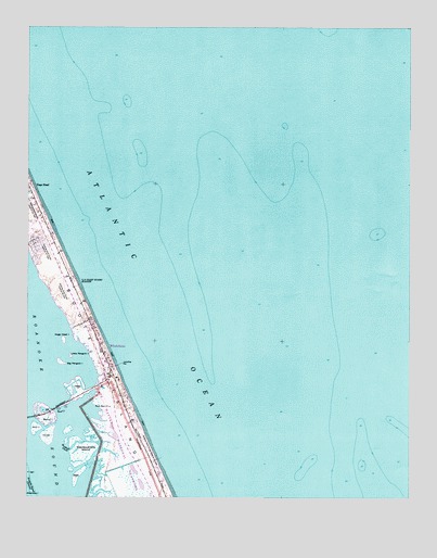
Roanoke Island NE, NC USGS Topographic Map
Click on map above to begin viewing in our Map Viewer.

This topographic map contains these locations and features:
Feature Name Type Latitude Longitude GNIS ID View Map
Bells IslandIslandN35.8805°W75.6082°980963View Map
Big Penguin IslandIslandN35.9113°W75.6135°981433View Map
Bodie IslandIslandN35.8943°W75.5896°1019241View Map
Bodie Island MarshesSwampN35.9010°W75.6063°1002332View Map
Cedar IslandIslandN35.9032°W75.6077°982873View Map
Cow Island (historical)IslandN35.8955°W75.5957°1018653View Map
Dare County Emergency Medical Services Station 5BuildingN35.9340°W75.6140°2720323View Map
Dare County Sheriff's OfficeBuildingN35.9446°W75.6173°2131011View Map
Green IslandsIslandN35.8863°W75.6177°1018646View Map
Grun IslandIslandN35.8929°W75.6221°986182View Map
Headquarters IslandIslandN35.8868°W75.6068°986567View Map
House IslandIslandN35.8907°W75.6182°987171View Map
Jeanettes PierLocaleN35.9107°W75.5946°987539View Map
Little Penguin IslandIslandN35.9127°W75.6104°988727View Map
Melvin R Daniels BridgeBridgeN35.8988°W75.6152°1002339View Map
Nags HeadPopulated PlaceN35.9574°W75.6241°1021599View Map
Nags Head Fire and Rescue Station 16BuildingN35.9340°W75.6141°2638326View Map
Nags Head Fire and Rescue Station 21BuildingN35.8866°W75.5852°2638727View Map
Nags Head IslandIslandN35.9168°W75.6132°990836View Map
Nags Head Police DepartmentBuildingN35.9345°W75.6127°2130927View Map
Nags Head Post OfficePost OfficeN35.9514°W75.6235°2773815View Map
Nags Head Post Office (historical)Post OfficeN35.9574°W75.6241°1940254View Map
Outer Banks Pier and Fishing CenterLocaleN35.8855°W75.5816°1002338View Map
Penguins IslandsIslandN35.9141°W75.6135°1018645View Map
Pond IslandIslandN35.8966°W75.6179°992654View Map
Roanoke Inlet (historical)GutN35.9002°W75.5954°1018654View Map
Rockhall CreekGutN35.8893°W75.6088°993542View Map
Seven SistersSummitN35.9488°W75.6246°1022548View Map
The Outer Banks HospitalHospitalN35.9398°W75.6177°2701497View Map
Township of Nags HeadCivilN35.8801°W75.6170°1026614View Map
WhaleboneAreaN35.9152°W75.5996°1002367View Map
WhalebonePopulated PlaceN35.9135°W75.5996°1023190View Map
Whalebone Junction Information StationParkN35.9046°W75.5979°1002362View Map

Note: Coordinates in the location and feature list above are referenced to NAD83 datum.


Copyright (C) 2008-2024 Ryan Niemi / Sunset Dynamics ... All Rights Reserved