TopoQuest Logo
Do you find TopoQuest useful?
Help keep TopoQuest running and adding new maps/features by donating!
Bitcoin:  19c7KJd3qBynnjoSw5npx9KScwjBe4ifkT
Litecoin:  LXs6TkuXGGXo1vDsWCkWVdjQX94eUKd6ui
Home View Maps Find Maps Find Places Resources & Links


Maple Hill, Kansas Topographic Map

USGS Map Title: Maple Hill, KS
USGS Map MRC: 39096A1
DRG (GeoTIFF) Download: o39096a1.tif


Neighboring USGS Topographic Map Quads:


  Belvue, KS  
39096B2
 

  Saint Marys, KS  
39096B1
 

  Rossville, KS  
39095B8
 

  McFarland, KS  
39096A2
 

  Maple Hill, KS  
39096A1
 

  Willard, KS  
39095A8
 

  Hessdale, KS  
38096H2
 

  Keene, KS  
38096H1
 

  Dover, KS  
38095H8


Map MRC Location:

N40°
W97°
N40°
W96°
H8 H7 H6 H5 H4 H3 H2 H1
G8 G7 G6 G5 G4 G3 G2 G1
F8 F7 F6 F5 F4 F3 F2 F1
E8 E7 E6 E5 E4 E3 E2 E1
D8 D7 D6 D5 D4 D3 D2 D1
C8 C7 C6 C5 C4 C3 C2 C1
B8 B7 B6 B5 B4 B3 B2 B1
A8 A7 A6 A5 A4 A3 A2 A1
N39°
W97°
N39°
W96°

Maple Hill, KS USGS 1:24K Topographic Map Preview:
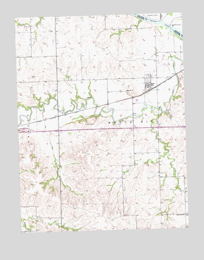
Maple Hill, KS USGS Topographic Map
Click on map above to begin viewing in our Map Viewer.

This topographic map contains these locations and features:
Feature Name Type Latitude Longitude GNIS ID View Map
Bourbonnais CreekStreamN39.1206°W96.0155°476258View Map
Buffalo MoundSummitN39.0619°W96.0739°476615View Map
City of Maple HillCivilN39.0853°W96.0281°2395839View Map
Dog CreekStreamN39.0714°W96.1055°476618View Map
Dry CreekStreamN39.0675°W96.0175°476619View Map
Freeman CemeteryCemeteryN39.0328°W96.0372°476493View Map
Kansas Department of Transportation Wabaunsee County Rest AreaLocaleN39.0597°W96.1212°2692538View Map
Maple HillPopulated PlaceN39.0847°W96.0280°476617View Map
Maple Hill ChurchChurchN39.0795°W96.0429°476616View Map
Maple Hill Community Congregational ChurchChurchN39.0850°W96.0257°2690396View Map
Maple Hill Grade SchoolSchoolN39.0828°W96.0290°2506628View Map
Maple Hill Police DepartmentBuildingN39.0821°W96.0271°2504206View Map
Maple Hill Post OfficePost OfficeN39.0826°W96.0269°2693843View Map
Maple Hill Wastewater Treatment PlantLocaleN39.0867°W96.0143°2691945View Map
Morelock Airport (historical)AirportN39.0306°W96.0230°481345View Map
Springside (historical)LocaleN39.0569°W96.0517°482007View Map
Sunny Side SchoolSchoolN39.0078°W96.0033°476614View Map
Tabor HillSummitN39.1122°W96.0789°476592View Map
Township of Maple HillCivilN39.0539°W96.0238°1729696View Map
VeraPopulated PlaceN39.0669°W96.0950°484785View Map
Wabaunsee County Fire District 4BuildingN39.0822°W96.0271°2111950View Map
WIBW-FM (Topeka)TowerN39.0053°W96.0497°481476View Map
WIBW-TV (Topeka)TowerN39.0050°W96.0494°481617View Map

Note: Coordinates in the location and feature list above are referenced to NAD83 datum.


Copyright (C) 2008-2025 Ryan Niemi / Sunset Dynamics ... All Rights Reserved