TopoQuest Logo
Do you find TopoQuest useful?
Help keep TopoQuest running and adding new maps/features by donating!
Bitcoin:  19c7KJd3qBynnjoSw5npx9KScwjBe4ifkT
Litecoin:  LXs6TkuXGGXo1vDsWCkWVdjQX94eUKd6ui
Home View Maps Find Maps Find Places Resources & Links


Marble Butte, Idaho Topographic Map

USGS Map Title: Marble Butte, ID
USGS Map MRC: 45115E7
DRG (GeoTIFF) Download: o45115e7.tif


Neighboring USGS Topographic Map Quads:


  Sawyer Ridge, ID  
45115F8
 

  Sourdough Peak, ID  
45115F7
 

  North Pole, ID  
45115F6
 

  Hanover Mountain, ID  
45115E8
 

  Marble Butte, ID  
45115E7
 

  Buffalo Hump, ID  
45115E6
 

  Carey Dome, ID  
45115D8
 

  Johnson Butte, ID  
45115D7
 

  Cottontail Point, ID  
45115D6


Map MRC Location:

N46°
W116°
N46°
W115°
H8 H7 H6 H5 H4 H3 H2 H1
G8 G7 G6 G5 G4 G3 G2 G1
F8 F7 F6 F5 F4 F3 F2 F1
E8 E7 E6 E5 E4 E3 E2 E1
D8 D7 D6 D5 D4 D3 D2 D1
C8 C7 C6 C5 C4 C3 C2 C1
B8 B7 B6 B5 B4 B3 B2 B1
A8 A7 A6 A5 A4 A3 A2 A1
N45°
W116°
N45°
W115°

Marble Butte, ID USGS 1:24K Topographic Map Preview:
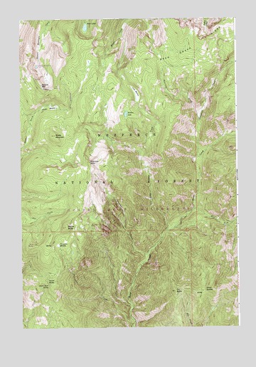
Marble Butte, ID USGS Topographic Map
Click on map above to begin viewing in our Map Viewer.

This topographic map contains these locations and features:
Feature Name Type Latitude Longitude GNIS ID View Map
Ace ButteSummitN45.5341°W115.8682°395038View Map
Anchor MeadowFlatN45.5896°W115.8593°376606View Map
Arizona CreekStreamN45.5624°W115.8015°400490View Map
Bear Grass RidgeRidgeN45.6166°W115.7696°377134View Map
East Fork Sheep CreekStreamN45.5480°W115.7760°381171View Map
Elk ButteSummitN45.5143°W115.7868°381332View Map
Gospel-Hump WildernessReserveN45.5761°W115.7712°401829View Map
Green SaddleGapN45.5146°W115.7704°382654View Map
Hidden LakeLakeN45.5865°W115.8142°383154View Map
Long MeadowFlatN45.6032°W115.8093°386069View Map
Long Meadow CreekStreamN45.5396°W115.7912°386070View Map
Marble ButteSummitN45.5407°W115.8493°386451View Map
North ButteSummitN45.5188°W115.8560°387619View Map
Peterson CreekStreamN45.5846°W115.7726°388370View Map
Plummer CreekStreamN45.5305°W115.8021°374459View Map
Plummer PointCliffN45.5668°W115.8357°374462View Map
Porcupine CreekStreamN45.5030°W115.8115°388752View Map
Porcupine MeadowFlatN45.5335°W115.8543°388764View Map
Sheep MountainSummitN45.5780°W115.8554°390243View Map
Slaughter CreekStreamN45.5688°W115.7740°390575View Map
Square MountainSummitN45.5985°W115.8635°397199View Map
Square Mountain LakeLakeN45.6060°W115.8653°395986View Map
Sweet Anise SpringSpringN45.5175°W115.8593°391765View Map
Twin LakesLakeN45.6216°W115.8371°392526View Map

Note: Coordinates in the location and feature list above are referenced to NAD83 datum.


Copyright (C) 2008-2025 Ryan Niemi / Sunset Dynamics ... All Rights Reserved