TopoQuest Logo
Do you find TopoQuest useful?
Help keep TopoQuest running and adding new maps/features by donating!
Bitcoin:  19c7KJd3qBynnjoSw5npx9KScwjBe4ifkT
Litecoin:  LXs6TkuXGGXo1vDsWCkWVdjQX94eUKd6ui
Home View Maps Find Maps Find Places Resources & Links


Buffalo Hump, Idaho Topographic Map

USGS Map Title: Buffalo Hump, ID
USGS Map MRC: 45115E6
DRG (GeoTIFF) Download: o45115e6.tif


Neighboring USGS Topographic Map Quads:


  Sourdough Peak, ID  
45115F7
 

  North Pole, ID  
45115F6
 

  Orogrande, ID  
45115F5
 

  Marble Butte, ID  
45115E7
 

  Buffalo Hump, ID  
45115E6
 

  Silver Spur Ridge, ID  
45115E5
 

  Johnson Butte, ID  
45115D7
 

  Cottontail Point, ID  
45115D6
 

  Mackay Bar, ID  
45115D5


Map MRC Location:

N46°
W116°
N46°
W115°
H8 H7 H6 H5 H4 H3 H2 H1
G8 G7 G6 G5 G4 G3 G2 G1
F8 F7 F6 F5 F4 F3 F2 F1
E8 E7 E6 E5 E4 E3 E2 E1
D8 D7 D6 D5 D4 D3 D2 D1
C8 C7 C6 C5 C4 C3 C2 C1
B8 B7 B6 B5 B4 B3 B2 B1
A8 A7 A6 A5 A4 A3 A2 A1
N45°
W116°
N45°
W115°

Buffalo Hump, ID USGS 1:24K Topographic Map Preview:
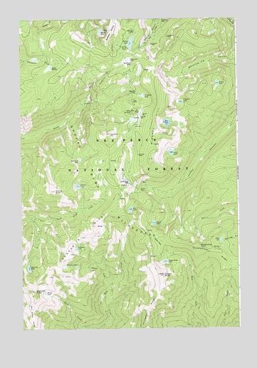
Buffalo Hump, ID USGS Topographic Map
Click on map above to begin viewing in our Map Viewer.

This topographic map contains these locations and features:
Feature Name Type Latitude Longitude GNIS ID View Map
Atlas MillLocaleN45.5949°W115.6857°376767View Map
Atlas MineMineN45.5913°W115.6871°376768View Map
Bear LakeLakeN45.5831°W115.6659°377173View Map
Big Buffalo MineMineN45.6074°W115.6882°377445View Map
Brandon CreekStreamN45.5174°W115.6993°378190View Map
Brandon LakesLakeN45.5253°W115.7190°378191View Map
Buffalo HumpSummitN45.6205°W115.7010°378443View Map
Butcher CreekStreamN45.5921°W115.7143°378593View Map
CalendarPopulated PlaceN45.6241°W115.6699°396210View Map
ConcordPopulated PlaceN45.5846°W115.6837°396321View Map
Concord HillSummitN45.5782°W115.7001°379611View Map
Concord Landing Strip (historical)AirportN45.5849°W115.6815°397331View Map
Crackerjack MineMineN45.6180°W115.6671°380013View Map
Crescent LakeLakeN45.5914°W115.6578°380059View Map
Deer LakeLakeN45.5482°W115.6873°380466View Map
Del Rio MineMineN45.5560°W115.6829°380484View Map
Drumlummen PointCliffN45.5332°W115.6487°380766View Map
Drumlummen RidgeRidgeN45.5266°W115.6254°380767View Map
Fawn LakeLakeN45.5356°W115.6356°381626View Map
FrogtownLocaleN45.5941°W115.6801°382111View Map
Grave Ajax MineMineN45.5874°W115.6879°382581View Map
Half Acre LakeLakeN45.5677°W115.7166°382809View Map
Horseshoe LakeLakeN45.5323°W115.7189°383421View Map
Hump LakeLakeN45.6152°W115.6890°383541View Map
HumptownLocaleN45.6085°W115.6887°383544View Map
Hurst LakeLakeN45.5145°W115.7368°383577View Map
Jumbo CampLocaleN45.5591°W115.6896°384044View Map
Jumbo MineMineN45.5591°W115.6818°384049View Map
Lucky Lad MineMineN45.6199°W115.6862°386272View Map
Mineral HillSummitN45.5893°W115.6660°386996View Map
Mirror LakeLakeN45.6200°W115.7039°387035View Map
Mother Lode MineMineN45.5874°W115.6835°387276View Map
Oregon ButteSummitN45.5216°W115.6693°387989View Map
Oregon Butte LakeLakeN45.5269°W115.6679°387990View Map
Quartzite ButteSummitN45.5149°W115.7435°388978View Map
Quartzite LakeLakeN45.5247°W115.7462°388980View Map
Quartzite RidgeRidgeN45.5374°W115.7079°388982View Map
Round LakeLakeN45.5425°W115.6739°389646View Map
Ruby LakeLakeN45.5709°W115.6636°389707View Map
Saint Louis MineMineN45.5702°W115.6840°389838View Map
Scotts BluffCliffN45.5991°W115.6912°393858View Map
Shining ButteSummitN45.5557°W115.7318°390327View Map
Shining LakeLakeN45.5576°W115.7179°390328View Map
Square LakeLakeN45.5987°W115.6366°391268View Map
Squaw MeadowFlatN45.6049°W115.7351°397200View Map
Tepee FlatsFlatN45.5374°W115.6746°391938View Map
Vesuvius MineMineN45.6149°W115.6760°392722View Map

Note: Coordinates in the location and feature list above are referenced to NAD83 datum.


Copyright (C) 2008-2025 Ryan Niemi / Sunset Dynamics ... All Rights Reserved