TopoQuest Logo
Do you find TopoQuest useful?
Help keep TopoQuest running and adding new maps/features by donating!
Bitcoin:  19c7KJd3qBynnjoSw5npx9KScwjBe4ifkT
Litecoin:  LXs6TkuXGGXo1vDsWCkWVdjQX94eUKd6ui
Home View Maps Find Maps Find Places Resources & Links


Marietta, Indiana Topographic Map

USGS Map Title: Marietta, IN
USGS Map MRC: 39085D8
DRG (GeoTIFF) Download: o39085d8.tif


Neighboring USGS Topographic Map Quads:


  Greenwood, IN  
39086E1
 

  Boggstown, IN  
39085E8
 

  Shelbyville, IN  
39085E7
 

  Franklin, IN  
39086D1
 

  Marietta, IN  
39085D8
 

  Lewis Creek, IN  
39085D7
 

  Nineveh, IN  
39086C1
 

  Edinburgh, IN  
39085C8
 

  Hope, IN  
39085C7


Map MRC Location:

N40°
W86°
N40°
W85°
H8 H7 H6 H5 H4 H3 H2 H1
G8 G7 G6 G5 G4 G3 G2 G1
F8 F7 F6 F5 F4 F3 F2 F1
E8 E7 E6 E5 E4 E3 E2 E1
D8 D7 D6 D5 D4 D3 D2 D1
C8 C7 C6 C5 C4 C3 C2 C1
B8 B7 B6 B5 B4 B3 B2 B1
A8 A7 A6 A5 A4 A3 A2 A1
N39°
W86°
N39°
W85°

Marietta, IN USGS 1:24K Topographic Map Preview:
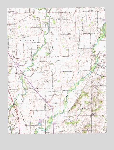
Marietta, IN USGS Topographic Map
Click on map above to begin viewing in our Map Viewer.

This topographic map contains these locations and features:
Feature Name Type Latitude Longitude GNIS ID View Map
Amity DitchCanalN39.4626°W85.9950°430142View Map
BengalPopulated PlaceN39.4734°W85.9228°430805View Map
Blue River ChurchChurchN39.4256°W85.8925°431244View Map
Brockman CemeteryCemeteryN39.4135°W85.9415°431556View Map
Conover CemeteryCemeteryN39.4033°W85.9157°432893View Map
Fisher DitchCanalN39.4626°W85.9414°434519View Map
Freeman CemeteryCemeteryN39.3761°W85.9898°434816View Map
Gibson DitchCanalN39.4981°W85.9447°435054View Map
Jollity ChurchChurchN39.4267°W85.9530°437073View Map
Major DitchCanalN39.4031°W85.9372°438491View Map
MariettaPopulated PlaceN39.4414°W85.8839°438606View Map
Marietta Volunteer Fire DepartmentBuildingN39.4417°W85.8826°2626332View Map
McCue Medsker DitchCanalN39.4509°W85.9200°438833View Map
Mount AuburnPopulated PlaceN39.3926°W85.8936°439520View Map
Plastics Park Airport (historical)AirportN39.3778°W85.9805°449150View Map
Shaw DitchCanalN39.4681°W85.8989°443317View Map
Shipp DitchCanalN39.4598°W85.9794°443411View Map
Skeeter LandingAirportN39.4781°W85.8846°2677082View Map
Smiley CemeteryCemeteryN39.4511°W85.9694°443657View Map
Tile CreekStreamN39.4076°W85.8880°447928View Map
Township of Blue RiverCivilN39.3906°W85.9902°453120View Map
Township of HendricksCivilN39.4808°W85.8941°453405View Map
Township of JacksonCivilN39.3938°W85.9004°453466View Map
Township of NeedhamCivilN39.4859°W85.9978°453658View Map

Note: Coordinates in the location and feature list above are referenced to NAD83 datum.


Copyright (C) 2008-2024 Ryan Niemi / Sunset Dynamics ... All Rights Reserved