TopoQuest Logo
Do you find TopoQuest useful?
Help keep TopoQuest running and adding new maps/features by donating!
Bitcoin:  19c7KJd3qBynnjoSw5npx9KScwjBe4ifkT
Litecoin:  LXs6TkuXGGXo1vDsWCkWVdjQX94eUKd6ui
Home View Maps Find Maps Find Places Resources & Links


Marmaduke, Arkansas Topographic Map

USGS Map Title: Marmaduke, AR
USGS Map MRC: 36090B4
DRG (GeoTIFF) Download: o36090b4.tif


Neighboring USGS Topographic Map Quads:


  Knobel, AR  
36090C5
 

  Boydsville, AR  
36090C4
 

  Rector, AR  
36090C3
 

  Lafe, AR  
36090B5
 

  Marmaduke, AR  
36090B4
 

  Mounds, AR  
36090B3
 

  Paragould West, AR  
36090A5
 

  Paragould East, AR  
36090A4
 

  Cardwell, MO  
36090A3


Map MRC Location:

N37°
W91°
N37°
W90°
H8 H7 H6 H5 H4 H3 H2 H1
G8 G7 G6 G5 G4 G3 G2 G1
F8 F7 F6 F5 F4 F3 F2 F1
E8 E7 E6 E5 E4 E3 E2 E1
D8 D7 D6 D5 D4 D3 D2 D1
C8 C7 C6 C5 C4 C3 C2 C1
B8 B7 B6 B5 B4 B3 B2 B1
A8 A7 A6 A5 A4 A3 A2 A1
N36°
W91°
N36°
W90°

Marmaduke, AR USGS 1:24K Topographic Map Preview:
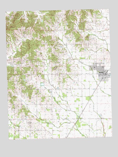
Marmaduke, AR USGS Topographic Map
Click on map above to begin viewing in our Map Viewer.

This topographic map contains these locations and features:
Feature Name Type Latitude Longitude GNIS ID View Map
City of MarmadukeCivilN36.1894°W90.3857°2405028View Map
Coopers School (historical)SchoolN36.2453°W90.3826°82688View Map
Cudd CemeteryCemeteryN36.2203°W90.3957°57618View Map
Culver CreekStreamN36.1526°W90.4245°48254View Map
Dickeys LakeReservoirN36.1817°W90.4184°79989View Map
Dickeys Lake DamDamN36.1817°W90.4184°79988View Map
Friends CemeteryCemeteryN36.1414°W90.4745°82693View Map
Friendship School (historical)SchoolN36.1337°W90.4740°82694View Map
Hartsoe CemeteryCemeteryN36.1834°W90.4370°49925View Map
Harveys Chapel CemeteryCemeteryN36.2131°W90.3907°64812View Map
Harveys Chapel United Methodist ChurchChurchN36.2140°W90.3915°77141View Map
Hickory Grove School (historical)SchoolN36.1878°W90.4279°82696View Map
Hurricane United Methodist ChurchChurchN36.1778°W90.4487°77260View Map
MarmadukePopulated PlaceN36.1870°W90.3832°58126View Map
Marmaduke Elementary SchoolSchoolN36.1934°W90.3952°64847View Map
Marmaduke Fire StationBuildingN36.1866°W90.3828°2116766View Map
Marmaduke High SchoolSchoolN36.1934°W90.3944°64848View Map
Marmaduke Police DepartmentBuildingN36.1885°W90.3892°2118539View Map
Marmaduke Post OfficePost OfficeN36.1867°W90.3845°84283View Map
New Friendship Baptist ChurchChurchN36.1412°W90.4740°82818View Map
New Home Missionary Baptist ChurchChurchN36.2170°W90.4276°77816View Map
Newberry School (historical)SchoolN36.1515°W90.4468°82703View Map
Nutts Chapel Baptist ChurchChurchN36.1295°W90.4020°77866View Map
Old Friendship Church (historical)ChurchN36.1303°W90.4476°82704View Map
Old Liberty CemeteryCemeteryN36.1434°W90.4479°82705View Map
Old Liberty ChurchChurchN36.1434°W90.4487°53007View Map
Paris (historical)Populated PlaceN36.1801°W90.4557°64866View Map
Providence Baptist ChurchChurchN36.2012°W90.4723°78108View Map
Ramer School (historical)SchoolN36.2453°W90.4462°82711View Map
Ramers Chapel United Methodist ChurchChurchN36.2351°W90.4426°82823View Map
Talken CemeteryCemeteryN36.2312°W90.4912°55419View Map
Toddsville School (historical)SchoolN36.1584°W90.4104°82717View Map
Township of FriendshipCivilN36.1408°W90.4386°66623View Map
Township of HopewellCivilN36.2386°W90.3856°66625View Map
Township of HurricaneCivilN36.1936°W90.4140°66626View Map
Union ChurchChurchN36.1442°W90.4162°55805View Map
Union Grove Church (historical)ChurchN36.2303°W90.4273°82719View Map
Upper Lake School (historical)SchoolN36.2401°W90.4954°82722View Map
Woods School (historical)SchoolN36.1731°W90.4826°82726View Map
Wright CemeteryCemeteryN36.2076°W90.4598°56555View Map

Note: Coordinates in the location and feature list above are referenced to NAD83 datum.


Copyright (C) 2008-2025 Ryan Niemi / Sunset Dynamics ... All Rights Reserved