TopoQuest Logo
Do you find TopoQuest useful?
Help keep TopoQuest running and adding new maps/features by donating!
Bitcoin:  19c7KJd3qBynnjoSw5npx9KScwjBe4ifkT
Litecoin:  LXs6TkuXGGXo1vDsWCkWVdjQX94eUKd6ui
Home View Maps Find Maps Find Places Resources & Links


Knobel, Arkansas Topographic Map

USGS Map Title: Knobel, AR
USGS Map MRC: 36090C5
DRG (GeoTIFF) Download: o36090c5.tif


Neighboring USGS Topographic Map Quads:


  Datto, AR  
36090D6
 

  Corning, AR  
36090D5
 

  McDougal, AR  
36090D4
 

  Peach Orchard, AR  
36090C6
 

  Knobel, AR  
36090C5
 

  Boydsville, AR  
36090C4
 

  Delaplaine, AR  
36090B6
 

  Lafe, AR  
36090B5
 

  Marmaduke, AR  
36090B4


Map MRC Location:

N37°
W91°
N37°
W90°
H8 H7 H6 H5 H4 H3 H2 H1
G8 G7 G6 G5 G4 G3 G2 G1
F8 F7 F6 F5 F4 F3 F2 F1
E8 E7 E6 E5 E4 E3 E2 E1
D8 D7 D6 D5 D4 D3 D2 D1
C8 C7 C6 C5 C4 C3 C2 C1
B8 B7 B6 B5 B4 B3 B2 B1
A8 A7 A6 A5 A4 A3 A2 A1
N36°
W91°
N36°
W90°

Knobel, AR USGS 1:24K Topographic Map Preview:
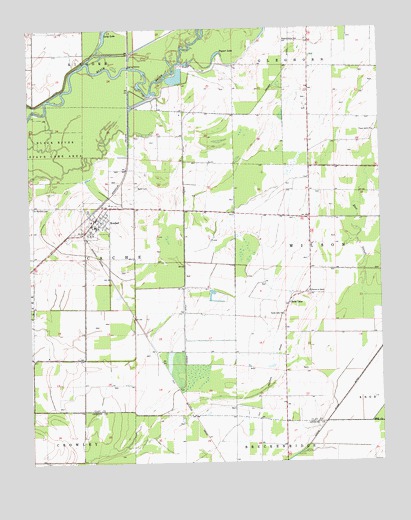
Knobel, AR USGS Topographic Map
Click on map above to begin viewing in our Map Viewer.

This topographic map contains these locations and features:
Feature Name Type Latitude Longitude GNIS ID View Map
Bond CemeteryCemeteryN36.3298°W90.5865°82804View Map
Cache LakePopulated PlaceN36.2956°W90.5332°76484View Map
Cache Lake ChurchChurchN36.2926°W90.5351°47264View Map
Cache Lake School (historical)SchoolN36.2990°W90.5257°82612View Map
Cache River Ditch Number 1CanalN36.2692°W90.5129°81986View Map
Church of ChristChurchN36.2992°W90.5254°62495View Map
City of KnobelCivilN36.3199°W90.6025°2404841View Map
East SloughGutN36.3167°W90.5087°48779View Map
Gilchrist CemeteryCemeteryN36.3228°W90.5887°82624View Map
Gum SloughGutN36.3473°W90.6171°82628View Map
KnobelPopulated PlaceN36.3201°W90.6021°58025View Map
Knobel Fire StationBuildingN36.3195°W90.6005°2116668View Map
Knobel Post OfficePost OfficeN36.3189°W90.6008°2781874View Map
Kramer DitchCanalN36.3340°W90.5704°50912View Map
Luehrmann (historical)Populated PlaceN36.3626°W90.5890°62508View Map
Mill CreekStreamN36.2615°W90.5043°52030View Map
New Hope School (historical)SchoolN36.3512°W90.5701°82654View Map
Old River LakeLakeN36.3659°W90.5746°82655View Map
Poyner LakeLakeN36.3674°W90.5580°75086View Map
Saint Bernard CemeteryCemeteryN36.3237°W90.6234°54313View Map
Sellmeyer (historical)Populated PlaceN36.2903°W90.5871°62514View Map
Thorn Grove ChurchChurchN36.3453°W90.5021°55551View Map
Thorn Grove School (historical)SchoolN36.3453°W90.5018°82667View Map
Thwait Back OutBayN36.3653°W90.5682°82668View Map
Township of Cache (historical)CivilN36.3278°W90.6001°63714View Map
Township of Cache-WilsonCivilN36.3169°W90.5756°2063358View Map
Township of Wilson (historical)CivilN36.3167°W90.5126°63732View Map
Walnut GrovePopulated PlaceN36.3715°W90.5248°82675View Map
Walnut Grove ChurchChurchN36.3717°W90.5287°56010View Map

Note: Coordinates in the location and feature list above are referenced to NAD83 datum.


Copyright (C) 2008-2025 Ryan Niemi / Sunset Dynamics ... All Rights Reserved