TopoQuest Logo
Do you find TopoQuest useful?
Help keep TopoQuest running and adding new maps/features by donating!
Bitcoin:  19c7KJd3qBynnjoSw5npx9KScwjBe4ifkT
Litecoin:  LXs6TkuXGGXo1vDsWCkWVdjQX94eUKd6ui
Home View Maps Find Maps Find Places Resources & Links


Marshall Creek, Michigan Topographic Map

USGS Map Title: Marshall Creek, MI
USGS Map MRC: 46089D5
DRG (GeoTIFF) Download: o46089d5.tif


Neighboring USGS Topographic Map Quads:


  Marenisco, MI  
46089D6
 

  Marshall Creek, MI  
46089D5


  Stateline Lake, MI  
46089C6
 

  Gogebic, MI  
46089C5


Map MRC Location:

N47°
W90°
N47°
W89°
H8 H7 H6 H5 H4 H3 H2 H1
G8 G7 G6 G5 G4 G3 G2 G1
F8 F7 F6 F5 F4 F3 F2 F1
E8 E7 E6 E5 E4 E3 E2 E1
D8 D7 D6 D5 D4 D3 D2 D1
C8 C7 C6 C5 C4 C3 C2 C1
B8 B7 B6 B5 B4 B3 B2 B1
A8 A7 A6 A5 A4 A3 A2 A1
N46°
W90°
N46°
W89°

Marshall Creek, MI USGS 1:24K Topographic Map Preview:
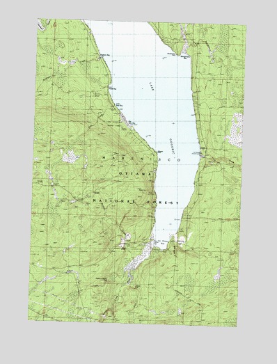
Marshall Creek, MI USGS Topographic Map
Click on map above to begin viewing in our Map Viewer.

This topographic map contains these locations and features:
Feature Name Type Latitude Longitude GNIS ID View Map
Alligator EyeSummitN46.4308°W89.5568°1619012View Map
Alligator Eye TrailTrailN46.4288°W89.5549°1622714View Map
Alligator PointCapeN46.4452°W89.5521°1619013View Map
Big Bear BayBayN46.4583°W89.5696°1622678View Map
Bingham BayBayN46.4883°W89.5813°1619215View Map
Bingham CreekStreamN46.4849°W89.5879°621385View Map
Gillis CreekStreamN46.4649°W89.5774°1620017View Map
Gogebic County ParkParkN46.4099°W89.5554°1622713View Map
Gogebic Lake State ParkParkN46.4588°W89.5771°1620033View Map
Ice House BayBayN46.4091°W89.5465°1620286View Map
Judson FallsFallsN46.3899°W89.5613°1620389View Map
Lake Gogebic Volunteer Fire Department Station 2 - East ShoreBuildingN46.4554°W89.5246°2626859View Map
Lake Gogebic Volunteer Fire Department Station 2 West ShoreBuildingN46.4821°W89.5860°2125237View Map
Little Bear BayBayN46.4652°W89.5768°1622677View Map
Marshall CreekStreamN46.4013°W89.5624°1620719View Map
Marshall FallsFallsN46.4166°W89.5738°1622712View Map
Montgomery BayBayN46.4841°W89.5363°1620882View Map
Montgomery CreekStreamN46.4877°W89.5371°1620883View Map
Montgomery PointCapeN46.4880°W89.5404°1620884View Map
Nelson Canyon FallsFallsN46.3922°W89.5790°1620996View Map
Nelson CreekStreamN46.3955°W89.5688°1620998View Map
Pabst BayBayN46.4711°W89.5768°1621139View Map
Pelton RiverStreamN46.3913°W89.5663°1621191View Map
Saint Thomas Church CampLocaleN46.4461°W89.5246°1622715View Map
Slate RiverStreamN46.4006°W89.5605°1621641View Map
Township of MareniscoCivilN46.3829°W89.5922°1626685View Map
Trout BrookStreamN46.4455°W89.5240°1621954View Map
White CityPopulated PlaceN46.4113°W89.5371°1622134View Map
White Horse CreekStreamN46.4113°W89.5432°1622141View Map

Note: Coordinates in the location and feature list above are referenced to NAD83 datum.


Copyright (C) 2008-2025 Ryan Niemi / Sunset Dynamics ... All Rights Reserved