TopoQuest Logo
Do you find TopoQuest useful?
Help keep TopoQuest running and adding new maps/features by donating!
Bitcoin:  19c7KJd3qBynnjoSw5npx9KScwjBe4ifkT
Litecoin:  LXs6TkuXGGXo1vDsWCkWVdjQX94eUKd6ui
Home View Maps Find Maps Find Places Resources & Links


Martinsdale, Montana Topographic Map

USGS Map Title: Martinsdale, MT
USGS Map MRC: 46110D3
DRG (GeoTIFF) Download: o46110d3.tif


Neighboring USGS Topographic Map Quads:


  Mount Howe, MT  
46110E4
 

  Mud Creek, MT  
46110E3
 

  Haymaker Ranch SW, MT  
46110E2
 

  Groveland, MT  
46110D4
 

  Martinsdale, MT  
46110D3
 

  Twodot NW, MT  
46110D2
 

  Lebo, MT  
46110C4
 

  Cinnamon Peak, MT  
46110C3
 

  Cinnamon Spring, MT  
46110C2


Map MRC Location:

N47°
W111°
N47°
W110°
H8 H7 H6 H5 H4 H3 H2 H1
G8 G7 G6 G5 G4 G3 G2 G1
F8 F7 F6 F5 F4 F3 F2 F1
E8 E7 E6 E5 E4 E3 E2 E1
D8 D7 D6 D5 D4 D3 D2 D1
C8 C7 C6 C5 C4 C3 C2 C1
B8 B7 B6 B5 B4 B3 B2 B1
A8 A7 A6 A5 A4 A3 A2 A1
N46°
W111°
N46°
W110°

Martinsdale, MT USGS 1:24K Topographic Map Preview:
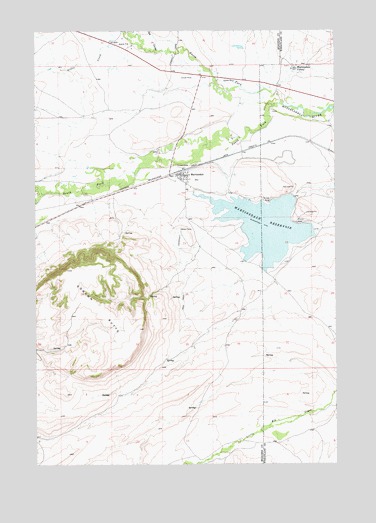
Martinsdale, MT USGS Topographic Map
Click on map above to begin viewing in our Map Viewer.

This topographic map contains these locations and features:
Feature Name Type Latitude Longitude GNIS ID View Map
08N11E11____01 WellWellN46.4680°W110.3138°816395View Map
08N11E14____01 WellWellN46.4536°W110.3138°816347View Map
08N11E14D___01 WellWellN46.4499°W110.3085°816328View Map
09N11E34C___01 WellWellN46.4933°W110.3299°816511View Map
Big CouleeValleyN46.4944°W110.3241°779781View Map
Charles M Bair Family MuseumBuildingN46.4666°W110.3174°1762858View Map
Clendennin School (historical)SchoolN46.4888°W110.3007°1762768View Map
East Martinsdale DamDamN46.4433°W110.2574°794963View Map
Gauglersville (historical)Populated PlaceN46.4916°W110.2757°1762752View Map
Gauglerville CemeteryCemeteryN46.4897°W110.2696°1725841View Map
Gauglerville School (historical)SchoolN46.4916°W110.2716°1725847View Map
Gillis CreekStreamN46.4961°W110.3341°783948View Map
Gordon ButteSummitN46.4183°W110.3549°771870View Map
MartinsdalePopulated PlaceN46.4583°W110.3132°773906View Map
Martinsdale (historical)LocaleN46.4597°W110.3138°1762740View Map
Martinsdale Census Designated PlaceCensusN46.4547°W110.3120°2583827View Map
Martinsdale ColonyPopulated PlaceN46.4894°W110.2674°773907View Map
Martinsdale Colony SchoolSchoolN46.4888°W110.2685°1725858View Map
Martinsdale Fire Service AreaBuildingN46.4571°W110.3143°2546748View Map
Martinsdale Post OfficePost OfficeN46.4570°W110.3147°1762712View Map
Martinsdale ReservoirReservoirN46.4432°W110.2796°773908View Map
Martinsdale Reservoir Fishing Access SiteLocaleN46.4505°W110.2819°1744435View Map
Martinsdale School (historical)SchoolN46.4591°W110.3130°1762739View Map
North Fork Musselshell RiverStreamN46.4797°W110.2724°788217View Map
North Martinsdale DamDamN46.4549°W110.2674°794985View Map
South Fork Musselshell RiverStreamN46.4794°W110.2724°791021View Map
Third Stooges DamDamN46.4783°W110.2891°798341View Map

Note: Coordinates in the location and feature list above are referenced to NAD83 datum.


Copyright (C) 2008-2025 Ryan Niemi / Sunset Dynamics ... All Rights Reserved