TopoQuest Logo
Do you find TopoQuest useful?
Help keep TopoQuest running and adding new maps/features by donating!
Bitcoin:  19c7KJd3qBynnjoSw5npx9KScwjBe4ifkT
Litecoin:  LXs6TkuXGGXo1vDsWCkWVdjQX94eUKd6ui
Home View Maps Find Maps Find Places Resources & Links


Mattituck, New York Topographic Map

USGS Map Title: Mattituck, NY
USGS Map MRC: 40072H5
DRG (GeoTIFF) Download: o40072h5.tif


Neighboring USGS Topographic Map Quads:


  Mattituck Hills, NY  
41072A5
 

  Southold, NY  
41072A4
 

  Riverhead, NY  
40072H6
 

  Mattituck, NY  
40072H5
 

  Southampton, NY  
40072H4
 

  Eastport, NY  
40072G6
 

  Quogue, NY  
40072G5
 

  Shinnecock Inlet, NY  
40072G4


Map MRC Location:

N41°
W73°
N41°
W72°
H8 H7 H6 H5 H4 H3 H2 H1
G8 G7 G6 G5 G4 G3 G2 G1
F8 F7 F6 F5 F4 F3 F2 F1
E8 E7 E6 E5 E4 E3 E2 E1
D8 D7 D6 D5 D4 D3 D2 D1
C8 C7 C6 C5 C4 C3 C2 C1
B8 B7 B6 B5 B4 B3 B2 B1
A8 A7 A6 A5 A4 A3 A2 A1
N40°
W73°
N40°
W72°

Mattituck, NY USGS 1:24K Topographic Map Preview:
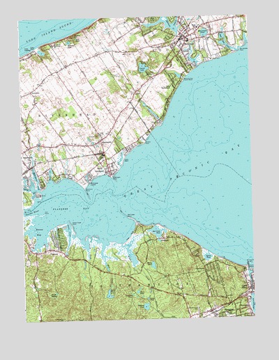
Mattituck, NY USGS Topographic Map
Click on map above to begin viewing in our Map Viewer.

This topographic map contains these locations and features:
Feature Name Type Latitude Longitude GNIS ID View Map
Aquebogue CemeteryCemeteryN40.9458°W72.6206°2105510View Map
Aquebogue Census Designated PlaceCensusN40.9425°W72.6149°2389141View Map
Bellows PondLakeN40.8803°W72.5588°943625View Map
Big E FarmLocaleN40.9844°W72.5806°2516319View Map
Birch CreekStreamN40.9087°W72.5920°943993View Map
Birch Creek PondReservoirN40.8997°W72.5917°2076278View Map
Browns PointCapeN40.9479°W72.5581°944950View Map
Brushs CreekStreamN40.9570°W72.5473°944981View Map
Brushs PointCapeN40.9559°W72.5493°974174View Map
Camp CareyLocaleN40.9895°W72.6054°945559View Map
Camp ImmaculateLocaleN40.9715°W72.5426°945603View Map
Camp MalloyLocaleN40.9773°W72.5562°945619View Map
Canoe PlacePopulated PlaceN40.8890°W72.5040°945786View Map
Church of the RedeemerChurchN40.9908°W72.5358°2076677View Map
Cow YardLocaleN40.9101°W72.5654°947595View Map
Crescent Duck FarmLocaleN40.9408°W72.6200°2516326View Map
Deep Hole CreekStreamN40.9884°W72.5112°948169View Map
Division PondLakeN40.8852°W72.5659°948497View Map
Duffy FarmsLocaleN40.8811°W72.6164°2516320View Map
East CreekStreamN40.9382°W72.5709°949050View Map
First Parish ChurchChurchN40.9692°W72.6189°2105516View Map
FlandersPopulated PlaceN40.9034°W72.6176°950227View Map
Flanders BayBayN40.9223°W72.5940°950228View Map
Flanders Census Designated PlaceCensusN40.8925°W72.6048°2389089View Map
Flanders Fire DepartmentBuildingN40.9033°W72.6215°2715873View Map
Flanders United Methodist ChurchChurchN40.9028°W72.6167°2516209View Map
Golden Earthworm Organic FarmLocaleN40.9353°W72.5936°2516325View Map
Goose CreekStreamN40.9159°W72.6009°951353View Map
Goose Creek PointCapeN40.9157°W72.5998°951356View Map
Grass PondLakeN40.8834°W72.5576°951545View Map
Great Peconic BayBayN40.9426°W72.5037°951645View Map
Hallocks PondLakeN40.9901°W72.5977°952066View Map
Hallockville Museum FarmLocaleN40.9831°W72.5911°2516316View Map
Hampton Bays CemeteryCemeteryN40.8809°W72.5308°952136View Map
Hampton Bays Fire StationBuildingN40.8771°W72.5267°2715896View Map
Hampton Bays Post OfficePost OfficeN40.8773°W72.5233°2713575View Map
Hampton Bays StationLocaleN40.8775°W72.5217°2076230View Map
Hampton Bays United Methodist ChurchChurchN40.8769°W72.5303°2076690View Map
Hampton Bays Volunteer AmbulanceBuildingN40.8751°W72.5267°2720775View Map
Horton CreekStreamN40.9737°W72.5356°973467View Map
House PondLakeN40.8864°W72.5633°953297View Map
Hubbard County ParkParkN40.9003°W72.5636°2076307View Map
Hubbard CreekStreamN40.9065°W72.5712°953354View Map
Indian IslandIslandN40.9270°W72.6162°953663View Map
Iron PointCapeN40.9193°W72.6134°953775View Map
Jacobs HillSummitN40.9920°W72.5959°953907View Map
James CreekStreamN40.9793°W72.5276°953923View Map
JamesportPopulated PlaceN40.9495°W72.5815°953924View Map
Jamesport CemeteryCemeteryN40.9488°W72.5821°2105511View Map
Jamesport Census Designated PlaceCensusN40.9546°W72.5807°2389977View Map
Jamesport Fire Department HeadquartersBuildingN40.9507°W72.5814°2715905View Map
Jamesport VineyardsLocaleN40.9700°W72.5656°2516435View Map
LaurelPopulated PlaceN40.9695°W72.5620°955082View Map
Laurel CemeteryCemeteryN40.9708°W72.5631°2105512View Map
Laurel Census Designated PlaceCensusN40.9729°W72.5561°2390036View Map
Laurel LakeLakeN40.9789°W72.5575°973388View Map
Laurel Lake VineyardsLocaleN40.9728°W72.5589°2516428View Map
Laurel Links Country ClubLocaleN40.9712°W72.5471°2715389View Map
Lily PondLakeN40.9918°W72.5940°955320View Map
Long CreekStreamN40.9965°W72.5404°955851View Map
Luce LandingLocaleN40.9857°W72.6181°956130View Map
Macari VineyardsLocaleN40.9875°W72.5683°2516429View Map
Maple SwampSwampN40.8848°W72.6090°956448View Map
Marratooka PointCapeN40.9857°W72.5048°956547View Map
Marratooka PondLakeN40.9931°W72.5240°956548View Map
Martha Clara VineyardsLocaleN40.9819°W72.5897°2516426View Map
MattituckPopulated PlaceN40.9912°W72.5343°956678View Map
Mattituck - Laurel LibraryBuildingN40.9922°W72.5301°2715322View Map
Mattituck AirportAirportN40.9903°W72.5203°978138View Map
Mattituck Fire DepartmentBuildingN40.9930°W72.5333°2715945View Map
Mattituck High SchoolSchoolN40.9953°W72.5278°2076679View Map
Mattituck Park District BeachParkN40.9745°W72.5362°956683View Map
Mattituck Post OfficePost OfficeN40.9918°W72.5345°2713582View Map
Mattituck Presbyterian ChurchChurchN40.9908°W72.5347°2076678View Map
Meetinghouse CreekStreamN40.9284°W72.6145°956918View Map
Meschutt Beach County ParkParkN40.8947°W72.5006°2076464View Map
Miamogue LagoonLakeN40.9332°W72.5893°957058View Map
Miamogue PointCapeN40.9343°W72.5762°957059View Map
Mill CreekStreamN40.9062°W72.5812°957216View Map
New Bethany CemeteryCemeteryN40.9869°W72.5376°2105514View Map
NewtownPopulated PlaceN40.8795°W72.5031°958531View Map
North Fork Unitarian Universalist FellowshipChurchN40.9501°W72.5809°2714562View Map
North Wind FarmLocaleN40.9719°W72.5883°2516318View Map
NorthvillePopulated PlaceN40.9701°W72.6190°958988View Map
Northville Census Designated PlaceCensusN40.9723°W72.6180°2389592View Map
Old Bethany CemeteryCemeteryN40.9904°W72.5351°2105513View Map
Old Steeple Community ChurchChurchN40.9467°W72.6217°2105515View Map
Palmer VineyardsLocaleN40.9694°W72.6247°2516423View Map
Paumanok VineyardsLocaleN40.9508°W72.6069°2516323View Map
Peconic RiverStreamN40.9223°W72.6162°970467View Map
Penny PondLakeN40.8973°W72.5546°960160View Map
Red Cedar PointCapeN40.9173°W72.5673°962274View Map
Red CreekPopulated PlaceN40.9062°W72.5523°973476View Map
Red Creek PondLakeN40.9112°W72.5523°962284View Map
Reeves BayBayN40.9123°W72.6154°962358View Map
Reeves CreekStreamN40.9326°W72.6095°962359View Map
Riverhaven ParkPopulated PlaceN40.9261°W72.6128°2461066View Map
Saint Rosalies Mission ChurchChurchN40.8792°W72.5214°2076692View Map
Sears - Bellows Pond County ParkParkN40.8822°W72.5669°2076436View Map
Sears PondLakeN40.8855°W72.5788°964747View Map
Shinnecock CanalCanalN40.8907°W72.5018°965126View Map
Shinnecock County MarinaLocaleN40.8936°W72.5014°2076254View Map
Shinnecock LightLocaleN40.8979°W72.5029°965131View Map
Simmons PointCapeN40.9298°W72.5909°965293View Map
Sound Avenue CemeteryCemeteryN40.9685°W72.6167°2651969View Map
South Avenue CemeteryCemeteryN40.9687°W72.6168°2105509View Map
South JamesportPopulated PlaceN40.9365°W72.5773°965793View Map
Southampton Town Police DepartmentBuildingN40.8864°W72.5381°2781215View Map
SouthportPopulated PlaceN40.9084°W72.5481°965912View Map
Squire PondLakeN40.9003°W72.5250°966176View Map
SquiretownPopulated PlaceN40.8948°W72.5265°966177View Map
Terrys CreekStreamN40.9295°W72.6170°974262View Map
Wehrman PondReservoirN40.9083°W72.5514°2076281View Map

Note: Coordinates in the location and feature list above are referenced to NAD83 datum.


Copyright (C) 2008-2025 Ryan Niemi / Sunset Dynamics ... All Rights Reserved