TopoQuest Logo
Do you find TopoQuest useful?
Help keep TopoQuest running and adding new maps/features by donating!
Bitcoin:  19c7KJd3qBynnjoSw5npx9KScwjBe4ifkT
Litecoin:  LXs6TkuXGGXo1vDsWCkWVdjQX94eUKd6ui
Home View Maps Find Maps Find Places Resources & Links


Maurice, South Dakota Topographic Map

USGS Map Title: Maurice, SD
USGS Map MRC: 44103D8
DRG (GeoTIFF) Download: o44103d8.tif


Neighboring USGS Topographic Map Quads:


  Beulah, WY  
44104E1
 

  Chicken Creek, SD  
44103E8
 

  Jolly, SD  
44103E7
 

  Tinton, SD  
44104D1
 

  Maurice, SD  
44103D8
 

  Spearfish, SD  
44103D7
 

  Old Baldy Mountain, SD  
44104C1
 

  Savoy, SD  
44103C8
 

  Lead, SD  
44103C7


Map MRC Location:

N45°
W104°
N45°
W103°
H8 H7 H6 H5 H4 H3 H2 H1
G8 G7 G6 G5 G4 G3 G2 G1
F8 F7 F6 F5 F4 F3 F2 F1
E8 E7 E6 E5 E4 E3 E2 E1
D8 D7 D6 D5 D4 D3 D2 D1
C8 C7 C6 C5 C4 C3 C2 C1
B8 B7 B6 B5 B4 B3 B2 B1
A8 A7 A6 A5 A4 A3 A2 A1
N44°
W104°
N44°
W103°

Maurice, SD USGS 1:24K Topographic Map Preview:
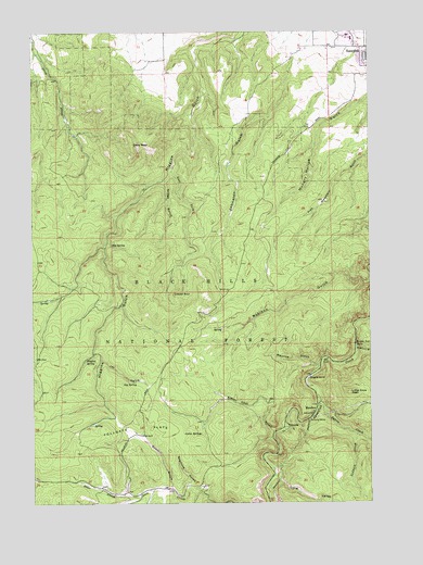
Maurice, SD USGS Topographic Map
Click on map above to begin viewing in our Map Viewer.

This topographic map contains these locations and features:
Feature Name Type Latitude Longitude GNIS ID View Map
Big Hill Ski TrailTrailN44.4089°W103.9338°1263092View Map
Big SpringSpringN44.4433°W103.9715°1261272View Map
Bridal Veil FallsFallsN44.4170°W103.8810°1261347View Map
Cabin SpringsSpringN44.3934°W103.9384°1261388View Map
Citadel RockPillarN44.4303°W103.9483°1261446View Map
Cleopatra CreekStreamN44.4014°W103.8948°1262497View Map
Cleopatra MineMineN44.3986°W103.8796°1264764View Map
Crow PeakSummitN44.4704°W103.9630°1261513View Map
Deer CreekStreamN44.3769°W103.9610°1261546View Map
East Fork Higgins GulchValleyN44.4633°W103.9485°1261614View Map
Eleven Hour GulchValleyN44.3937°W103.9115°1261628View Map
Griggs GulchValleyN44.4605°W103.9519°1261752View Map
Higgins SpringSpringN44.4124°W103.9809°1261811View Map
Homestake Camp (historical)LocaleN44.4055°W103.8963°1264558View Map
Jay GulchValleyN44.4129°W103.9752°1261882View Map
Jay SpringSpringN44.4067°W103.9677°1261883View Map
Johnston GulchValleyN44.4937°W103.9023°1261900View Map
Little Crow PeakSummitN44.4044°W103.8830°1261969View Map
Long ValleyValleyN44.3816°W103.9105°1261992View Map
MauricePopulated PlaceN44.3978°W103.8977°1262031View Map
Maurice GulchValleyN44.4112°W103.8945°1262032View Map
Prospect GulchValleyN44.3775°W103.9572°1262246View Map
Redpath CreekStreamN44.3933°W103.8805°1262288View Map
Rubicon GulchValleyN44.4163°W103.8804°1262336View Map
Sawmill GulchValleyN44.3794°W103.9499°1262365View Map
Seamore GulchValleyN44.3802°W103.9420°1262380View Map
Tollgate FlatsFlatN44.3950°W103.9613°1262597View Map
Unorganized Territory of North LawrenceCivilN44.4773°W103.9339°1267508View Map
VictoriaPopulated PlaceN44.3950°W103.9077°1262637View Map
Vitoria MineMineN44.3917°W103.8963°1264719View Map

Note: Coordinates in the location and feature list above are referenced to NAD83 datum.


Copyright (C) 2008-2024 Ryan Niemi / Sunset Dynamics ... All Rights Reserved