TopoQuest Logo
Do you find TopoQuest useful?
Help keep TopoQuest running and adding new maps/features by donating!
Bitcoin:  19c7KJd3qBynnjoSw5npx9KScwjBe4ifkT
Litecoin:  LXs6TkuXGGXo1vDsWCkWVdjQX94eUKd6ui
Home View Maps Find Maps Find Places Resources & Links


Maverick, Arizona Topographic Map

USGS Map Title: Maverick, AZ
USGS Map MRC: 33109F5
DRG (GeoTIFF) Download: o33109f5.tif


Neighboring USGS Topographic Map Quads:


  Marshall Butte, AZ  
33109G6
 

  Bonito Rock, AZ  
33109G5
 

  Big Lake South, AZ  
33109G4
 

  Odart Mountain, AZ  
33109F6
 

  Maverick, AZ  
33109F5
 

  Hoodoo Knoll, AZ  
33109F4
 

  Maverick SW, AZ  
33109E6
 

  Freezeout Mountain, AZ  
33109E5
 

  Baldy Bill Point, AZ  
33109E4


Map MRC Location:

N34°
W110°
N34°
W109°
H8 H7 H6 H5 H4 H3 H2 H1
G8 G7 G6 G5 G4 G3 G2 G1
F8 F7 F6 F5 F4 F3 F2 F1
E8 E7 E6 E5 E4 E3 E2 E1
D8 D7 D6 D5 D4 D3 D2 D1
C8 C7 C6 C5 C4 C3 C2 C1
B8 B7 B6 B5 B4 B3 B2 B1
A8 A7 A6 A5 A4 A3 A2 A1
N33°
W110°
N33°
W109°

Maverick, AZ USGS 1:24K Topographic Map Preview:
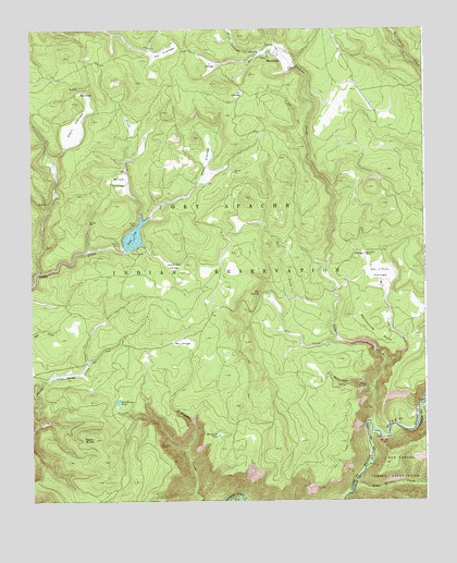
Maverick, AZ USGS Topographic Map
Click on map above to begin viewing in our Map Viewer.

This topographic map contains these locations and features:
Feature Name Type Latitude Longitude GNIS ID View Map
Battleground CreekStreamN33.6545°W109.5159°1082View Map
Battleground Number One TankReservoirN33.6499°W109.5264°21519View Map
Bear CreekStreamN33.6528°W109.5006°26080View Map
Bear Wallow CreekStreamN33.6292°W109.5229°26135View Map
Bee CienegaFlatN33.6673°W109.5776°1179View Map
Bluff Cienega CreekStreamN33.7420°W109.5429°1755View Map
Elk CienegaFlatN33.7326°W109.5584°4410View Map
Ess CreekStreamN33.6676°W109.5279°4495View Map
Ess SpringSpringN33.6803°W109.5529°4496View Map
Hawks Nest CienegaFlatN33.6876°W109.5798°5635View Map
MaverickPopulated PlaceN33.7428°W109.5473°24510View Map
McDonald TankReservoirN33.6425°W109.5661°7826View Map
Milk CreekStreamN33.6614°W109.5131°8049View Map
Odart CienegaFlatN33.7245°W109.6101°8919View Map
Odart RanchLocaleN33.7334°W109.6073°8921View Map
Pacheta CreekStreamN33.6459°W109.5179°9084View Map
Paddy ButteSummitN33.6417°W109.6051°9100View Map
Paddy CienegaFlatN33.6584°W109.6148°9101View Map
Pair o'Dice CienegaFlatN33.6851°W109.5148°9117View Map
Pair o'Dice RanchLocaleN33.6909°W109.5190°9118View Map
Pat CienegaFlatN33.7434°W109.5826°9250View Map
Rattlesnake PointCliffN33.6689°W109.5154°9978View Map
Salt House TankReservoirN33.6514°W109.5979°10754View Map
Sheep CienegaFlatN33.7148°W109.5693°11176View Map
Spud CreekStreamN33.6742°W109.5290°11717View Map
Tonto DamDamN33.6917°W109.5956°21848View Map
Tonto LakeReservoirN33.6951°W109.5925°12608View Map
Willow CienegaFlatN33.7095°W109.5968°13824View Map
Y CienegaFlatN33.7412°W109.5673°14024View Map

Note: Coordinates in the location and feature list above are referenced to NAD83 datum.


Copyright (C) 2008-2025 Ryan Niemi / Sunset Dynamics ... All Rights Reserved