TopoQuest Logo
Do you find TopoQuest useful?
Help keep TopoQuest running and adding new maps/features by donating!
Bitcoin:  19c7KJd3qBynnjoSw5npx9KScwjBe4ifkT
Litecoin:  LXs6TkuXGGXo1vDsWCkWVdjQX94eUKd6ui
Home View Maps Find Maps Find Places Resources & Links


Maybee, Michigan Topographic Map

USGS Map Title: Maybee, MI
USGS Map MRC: 42083A5
DRG (GeoTIFF) Download: o42083a5.tif


Neighboring USGS Topographic Map Quads:


  Ypsilanti West, MI  
42083B6
 

  Ypsilanti East, MI  
42083B5
 

  Belleville, MI  
42083B4
 

  Milan, MI  
42083A6
 

  Maybee, MI  
42083A5
 

  Carleton, MI  
42083A4
 

  Dundee, MI  
41083H6
 

  Ida, MI  
41083H5
 

  Monroe, MI  
41083H4


Map MRC Location:

N43°
W84°
N43°
W83°
H8 H7 H6 H5 H4 H3 H2 H1
G8 G7 G6 G5 G4 G3 G2 G1
F8 F7 F6 F5 F4 F3 F2 F1
E8 E7 E6 E5 E4 E3 E2 E1
D8 D7 D6 D5 D4 D3 D2 D1
C8 C7 C6 C5 C4 C3 C2 C1
B8 B7 B6 B5 B4 B3 B2 B1
A8 A7 A6 A5 A4 A3 A2 A1
N42°
W84°
N42°
W83°

Maybee, MI USGS 1:24K Topographic Map Preview:
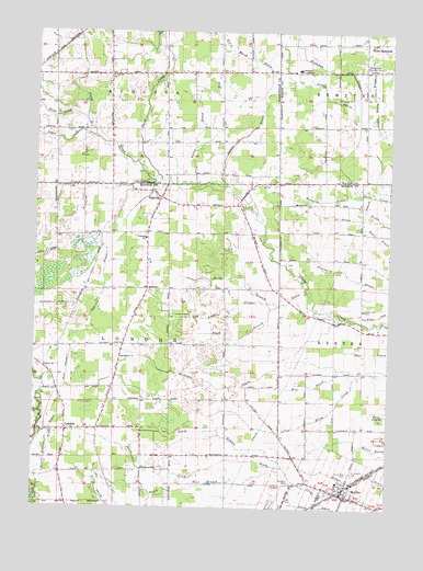
Maybee, MI USGS Topographic Map
Click on map above to begin viewing in our Map Viewer.

This topographic map contains these locations and features:
Feature Name Type Latitude Longitude GNIS ID View Map
Amos Palmer DrainStreamN42.0573°W83.5294°620070View Map
Antes DrainStreamN42.0009°W83.5041°619740View Map
Bear CreekStreamN42.0245°W83.6222°620839View Map
Beaver Meadow DrainStreamN42.0031°W83.6235°620950View Map
Bethlehem ChurchChurchN42.0392°W83.5941°621238View Map
Big Marsh DrainStreamN42.1084°W83.5460°621334View Map
Bitz DrainStreamN42.0359°W83.5102°621468View Map
Blue Bush CemeteryCemeteryN42.0286°W83.5503°2439380View Map
Bradshaw DrainStreamN42.0828°W83.5108°621856View Map
Brainard SchoolSchoolN42.0706°W83.5858°621871View Map
Buck CreekStreamN42.1020°W83.6074°622170View Map
Childs CemeteryCemeteryN42.1248°W83.5819°623193View Map
County Line CemeteryCemeteryN42.0842°W83.6113°623884View Map
Herkimer DrainStreamN42.0503°W83.5194°628130View Map
Hoffman Junior High SchoolSchoolN42.1153°W83.5327°628378View Map
Johnston AirportAirportN42.0847°W83.5179°2717701View Map
Lamke DrainStreamN42.1025°W83.5113°630105View Map
Laszlo AirportAirportN42.0776°W83.6099°1624045View Map
Lelsey DrainStreamN42.0850°W83.5688°630298View Map
LondonPopulated PlaceN42.0200°W83.6133°630890View Map
London - Maybee - Raisinville Volunteer Fire DepartmentBuildingN42.0001°W83.5255°2620081View Map
London ChurchChurchN42.0367°W83.6210°630891View Map
London Post Office (historical)Post OfficeN42.0200°W83.6133°2438731View Map
London Seventh Day Adventist ChurchChurchN42.0247°W83.5997°2633963View Map
London Township CemeteryCemeteryN42.0375°W83.6222°2439381View Map
MaybeePopulated PlaceN42.0039°W83.5155°631766View Map
Maybee AirportAirportN42.0407°W83.5666°2650907View Map
Maybee Post Office (historical)Post OfficeN42.0047°W83.5128°2438841View Map
Maybee Public LibraryBuildingN42.0042°W83.5156°2438844View Map
Maybee QuarryMineN42.0169°W83.5039°2725143View Map
Maybee StationLocaleN42.0050°W83.5153°2438840View Map
Metropolitan Memorial ParkCemeteryN42.1161°W83.5066°632172View Map
Muehleisen Road CemeteryCemeteryN42.0055°W83.5750°2439378View Map
Nelsonville Post Office (historical)Post OfficeN42.0850°W83.5917°2646720View Map
North Branch Amos Palmer DrainStreamN42.0542°W83.5427°633487View Map
North Branch Sandy CreekStreamN42.0109°W83.5363°633536View Map
North Side CemeteryCemeteryN42.0095°W83.5133°633657View Map
OakvillePopulated PlaceN42.0814°W83.5808°633905View Map
Oakville DrainStreamN42.0848°W83.5830°633906View Map
Oakville Post Office (historical)Post OfficeN42.0814°W83.5808°2438724View Map
Paint CreekStreamN42.0848°W83.5797°634296View Map
Polzin DrainStreamN42.0848°W83.5574°635212View Map
Pool CemeteryCemeteryN42.0761°W83.5972°2439379View Map
Richards DrainStreamN42.0828°W83.5102°635863View Map
Saint Joseph ChurchChurchN42.0056°W83.5172°2438843View Map
Saint Josephs CemeteryCemeteryN42.0089°W83.5122°636805View Map
Saint Josephs CemeteryCemeteryN42.1131°W83.5999°636806View Map
Saint Paul Missionary Baptist ChurchChurchN42.0478°W83.5905°2633962View Map
Saint Pauls CemeteryCemeteryN42.0067°W83.5338°637001View Map
Sandy Hill CemeteryCemeteryN42.0525°W83.5088°637230View Map
South Branch Amos Palmer DrainStreamN42.0525°W83.5416°638272View Map
South Branch Sandy CreekStreamN42.0114°W83.5427°638310View Map
Sugar CreekStreamN42.0975°W83.6044°639017View Map
Township of LondonCivilN42.0415°W83.5968°1626639View Map
Village of MaybeeCivilN42.0063°W83.5154°2399278View Map
West SumpterPopulated PlaceN42.1225°W83.5094°1616181View Map
West Sumpter Post Office (historical)Post OfficeN42.1225°W83.5094°2650172View Map
Weyher FarmsLocaleN42.0031°W83.5078°2740353View Map

Note: Coordinates in the location and feature list above are referenced to NAD83 datum.


Copyright (C) 2008-2024 Ryan Niemi / Sunset Dynamics ... All Rights Reserved