TopoQuest Logo
Do you find TopoQuest useful?
Help keep TopoQuest running and adding new maps/features by donating!
Bitcoin:  19c7KJd3qBynnjoSw5npx9KScwjBe4ifkT
Litecoin:  LXs6TkuXGGXo1vDsWCkWVdjQX94eUKd6ui
Home View Maps Find Maps Find Places Resources & Links


Milan, Michigan Topographic Map

USGS Map Title: Milan, MI
USGS Map MRC: 42083A6
DRG (GeoTIFF) Download: o42083a6.tif


Neighboring USGS Topographic Map Quads:


  Saline, MI  
42083B7
 

  Ypsilanti West, MI  
42083B6
 

  Ypsilanti East, MI  
42083B5
 

  Macon, MI  
42083A7
 

  Milan, MI  
42083A6
 

  Maybee, MI  
42083A5
 

  Deerfield, MI  
41083H7
 

  Dundee, MI  
41083H6
 

  Ida, MI  
41083H5


Map MRC Location:

N43°
W84°
N43°
W83°
H8 H7 H6 H5 H4 H3 H2 H1
G8 G7 G6 G5 G4 G3 G2 G1
F8 F7 F6 F5 F4 F3 F2 F1
E8 E7 E6 E5 E4 E3 E2 E1
D8 D7 D6 D5 D4 D3 D2 D1
C8 C7 C6 C5 C4 C3 C2 C1
B8 B7 B6 B5 B4 B3 B2 B1
A8 A7 A6 A5 A4 A3 A2 A1
N42°
W84°
N42°
W83°

Milan, MI USGS 1:24K Topographic Map Preview:
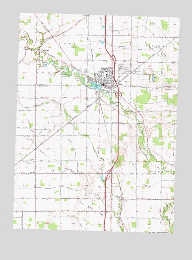
Milan, MI USGS Topographic Map
Click on map above to begin viewing in our Map Viewer.

This topographic map contains these locations and features:
Feature Name Type Latitude Longitude GNIS ID View Map
AzaliaPopulated PlaceN42.0189°W83.6658°620397View Map
Azalia Methodist Episcopal CemeteryCemeteryN42.0155°W83.6667°2438943View Map
Azalia Post OfficePost OfficeN42.0189°W83.6658°2438743View Map
Azalia StationLocaleN42.0186°W83.6658°2438744View Map
Bear Swamp CreekStreamN42.0081°W83.6674°620877View Map
Calvary Baptist ChurchChurchN42.0731°W83.6619°2633953View Map
Center CreekStreamN42.0220°W83.6891°622975View Map
Church of ChristChurchN42.0914°W83.6847°2647730View Map
City of MilanCivilN42.0820°W83.6848°1626740View Map
Cone DrainStreamN42.0242°W83.7333°623691View Map
Federal Correctional InstitutionLocaleN42.0948°W83.6699°1623345View Map
Federal Correctional Institution MilanBuildingN42.0957°W83.6695°2767918View Map
Foodtown Shopping CenterLocaleN42.0897°W83.6973°2342822View Map
Immaculate Conception ParishChurchN42.0883°W83.6822°2647735View Map
Interchange 22CrossingN42.0333°W83.6761°2438965View Map
Interchange 25CrossingN42.0792°W83.6717°2438942View Map
Interchange 27CrossingN42.1006°W83.6767°2646821View Map
Jehovah's WitnessesChurchN42.0942°W83.6781°2647764View Map
Jones SchoolSchoolN42.0325°W83.7347°629380View Map
KC CampgroundsLocaleN42.0625°W83.6447°2633961View Map
Leet Weidner DrainStreamN42.0134°W83.6763°630273View Map
Marble Memorial United Methodist ChurchChurchN42.0839°W83.6814°2633954View Map
Marble Park CemeteryCemeteryN42.0925°W83.6972°631534View Map
McIntyre DrainStreamN42.1070°W83.6438°631921View Map
Midway ChurchChurchN42.0281°W83.6738°632289View Map
MilanPopulated PlaceN42.0853°W83.6824°632302View Map
Milan AirportAirportN42.0522°W83.7414°1624044View Map
Milan Area Fire DepartmentBuildingN42.0837°W83.6836°2619966View Map
Milan Baptist ChurchChurchN42.0853°W83.6819°2647734View Map
Milan Family PracticeHospitalN42.0981°W83.6806°2647979View Map
Milan Fire DepartmentBuildingN42.0836°W83.6833°2633957View Map
Milan Free Methodist ChurchChurchN42.0969°W83.6792°2647733View Map
Milan High SchoolSchoolN42.0789°W83.7022°2633960View Map
Milan Middle SchoolSchoolN42.0922°W83.6814°2647741View Map
Milan Police DepartmentBuildingN42.0813°W83.6843°2633955View Map
Milan Post OfficePost OfficeN42.0845°W83.6815°2647739View Map
Milan Public LibraryBuildingN42.0811°W83.6833°2633956View Map
Milan StationLocaleN42.0765°W83.6860°2633964View Map
MoorevillePopulated PlaceN42.1031°W83.7333°632661View Map
Mooreville CemeteryCemeteryN42.1042°W83.7430°632662View Map
Nature ParkParkN42.0844°W83.6933°2647738View Map
Nolan Engle DrainStreamN42.0328°W83.6988°633448View Map
Nora Post Office (historical)Post OfficeN42.1244°W83.6986°2646719View Map
Nora Station (historical)LocaleN42.1244°W83.6986°2646678View Map
Paddock Elementary SchoolSchoolN42.0903°W83.6806°2647978View Map
Peoples Presbyterian ChurchChurchN42.0900°W83.6797°2647732View Map
Rice CemeteryCemeteryN42.0567°W83.7352°635835View Map
Rice DrainStreamN42.0581°W83.7386°635839View Map
Saint Marys CemeteryCemeteryN42.0398°W83.7388°636876View Map
Saint Paul's Lutheran ChurchChurchN42.0844°W83.6758°2647766View Map
Sanford Road ParkParkN42.0958°W83.6597°2647736View Map
Sherman Wilson DrainStreamN42.0542°W83.6502°637773View Map
Spaulding CemeteryCemeteryN42.0700°W83.6591°638473View Map
Symons Elementary SchoolSchoolN42.0806°W83.6969°2633958View Map
Township of MilanCivilN42.0375°W83.7158°1626739View Map
Vineyard Church of MilanChurchN42.0853°W83.6753°2647729View Map
Wilson ParkParkN42.0833°W83.6833°2633959View Map
YorkPopulated PlaceN42.1017°W83.7349°1616985View Map
York Post Office (historical)Post OfficeN42.1031°W83.7333°2646681View Map

Note: Coordinates in the location and feature list above are referenced to NAD83 datum.


Copyright (C) 2008-2024 Ryan Niemi / Sunset Dynamics ... All Rights Reserved