TopoQuest Logo
Do you find TopoQuest useful?
Help keep TopoQuest running and adding new maps/features by donating!
Bitcoin:  19c7KJd3qBynnjoSw5npx9KScwjBe4ifkT
Litecoin:  LXs6TkuXGGXo1vDsWCkWVdjQX94eUKd6ui
Home View Maps Find Maps Find Places Resources & Links


Bear Harbor, California Topographic Map

USGS Map Title: Bear Harbor, CA
USGS Map MRC: 39123H8
DRG (GeoTIFF) Download: o39123h8.tif


Neighboring USGS Topographic Map Quads:


  Shelter Cove, CA  
40124A1
 

  Briceland, CA  
40123A8
 

  Garberville, CA  
40123A7


  Bear Harbor, CA  
39123H8
 

  Piercy, CA  
39123H7


  Mistake Point, CA  
39123G8
 

  Hales Grove, CA  
39123G7


Map MRC Location:

N40°
W124°
N40°
W123°
H8 H7 H6 H5 H4 H3 H2 H1
G8 G7 G6 G5 G4 G3 G2 G1
F8 F7 F6 F5 F4 F3 F2 F1
E8 E7 E6 E5 E4 E3 E2 E1
D8 D7 D6 D5 D4 D3 D2 D1
C8 C7 C6 C5 C4 C3 C2 C1
B8 B7 B6 B5 B4 B3 B2 B1
A8 A7 A6 A5 A4 A3 A2 A1
N39°
W124°
N39°
W123°

Bear Harbor, CA USGS 1:24K Topographic Map Preview:
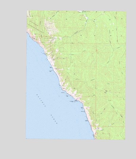
Bear Harbor, CA USGS Topographic Map
Click on map above to begin viewing in our Map Viewer.

This topographic map contains these locations and features:
Feature Name Type Latitude Longitude GNIS ID View Map
Anderson CreekStreamN39.9465°W123.8989°218252View Map
Bear HarborBayN39.9129°W123.9381°1666467View Map
Bear Harbor CampLocaleN39.9143°W123.9392°1724369View Map
Bear Harbor RanchLocaleN39.9140°W123.9378°218854View Map
Bear LandingLocaleN39.9165°W123.9425°254351View Map
Cluster Cone RocksIslandN39.9115°W123.9397°221267View Map
Couborn CreekStreamN39.9635°W123.8917°221667View Map
Double RockIslandN39.9415°W123.9689°222550View Map
Duffys GulchValleyN39.9082°W123.9289°1724079View Map
Duffys ReefBarN39.9054°W123.9289°222702View Map
East Branch North Fork Jackass CreekStreamN39.8957°W123.9134°222860View Map
Flat Rock CreekStreamN39.9274°W123.9575°223588View Map
Four CornersLocaleN39.9729°W123.9659°223742View Map
High TipSummitN39.9235°W123.9534°225282View Map
Jackass CreekStreamN39.8807°W123.9153°226050View Map
Jackass RidgeRidgeN39.9004°W123.8845°234077View Map
Jackson PinnaclePillarN39.8930°W123.9227°226090View Map
Jones Beach CampLocaleN39.9532°W123.9717°1724097View Map
KennyPopulated PlaceN39.9218°W123.8986°252710View Map
Low Gap CampLocaleN39.9574°W123.9481°1724370View Map
Low Gap CreekStreamN39.9496°W123.9714°227748View Map
Moody CreekStreamN39.9615°W123.8756°229000View Map
Morgan RockArchN39.9171°W123.9472°229055View Map
Needle RockArchN39.9445°W123.9687°229443View Map
Needle Rock CampLocaleN39.9438°W123.9653°1724371View Map
Needle Rock Ranch (historical)LocaleN39.9426°W123.9642°1724116View Map
Needle Rock Visitors CenterBuildingN39.9429°W123.9645°1724372View Map
North Fork Jackass CreekStreamN39.8849°W123.9122°229685View Map
North RockIslandN39.9199°W123.9520°229751View Map
Orchard CampLocaleN39.9196°W123.9431°1724373View Map
Our Lady of the Redwoods AbbeyChurchN39.9996°W123.9297°230152View Map
Point No PassCliffN39.9721°W123.9906°230862View Map
Railroad CampLocaleN39.9182°W123.9403°1724374View Map
School Marm GroveWoodsN39.8899°W123.9159°1724375View Map
Seal RocksIslandN39.9021°W123.9270°232759View Map
Sebbas CreekStreamN39.9671°W123.8803°234667View Map
Sinkyone State WildernessReserveN39.9104°W123.9265°2741122View Map
Sinkyone Wilderness State ParkParkN39.9229°W123.9434°1724376View Map
Streamside CampLocaleN39.9463°W123.9672°1724377View Map
Thompson CreekStreamN39.9999°W123.9381°236267View Map
Whale GulchValleyN39.9626°W123.9781°237585View Map
Whale Gulch Elementary SchoolSchoolN39.9840°W123.9756°2516087View Map
Whale Gulch Volunteer Fire DepartmentBuildingN39.9829°W123.9760°2622061View Map
WheelerPopulated PlaceN39.8854°W123.9111°252829View Map
Wheeler CampLocaleN39.8851°W123.9114°1724378View Map

Note: Coordinates in the location and feature list above are referenced to NAD83 datum.


Copyright (C) 2008-2024 Ryan Niemi / Sunset Dynamics ... All Rights Reserved