TopoQuest Logo
Do you find TopoQuest useful?
Help keep TopoQuest running and adding new maps/features by donating!
Bitcoin:  19c7KJd3qBynnjoSw5npx9KScwjBe4ifkT
Litecoin:  LXs6TkuXGGXo1vDsWCkWVdjQX94eUKd6ui
Home View Maps Find Maps Find Places Resources & Links


McAlpin, Florida Topographic Map

USGS Map Title: McAlpin, FL
USGS Map MRC: 30082B8
DRG (GeoTIFF) Download: o30082b8.tif


Neighboring USGS Topographic Map Quads:


  Live Oak West, FL  
30083C1
 

  Live Oak East, FL  
30082C8
 

  White Springs West, FL  
30082C7
 

  Mayo NE, FL  
30083B1
 

  McAlpin, FL  
30082B8
 

  Wellborn, FL  
30082B7
 

  Mayo SE, FL  
30083A1
 

  O'Brien, FL  
30082A8
 

  O'Brien SE, FL  
30082A7


Map MRC Location:

N31°
W83°
N31°
W82°
H8 H7 H6 H5 H4 H3 H2 H1
G8 G7 G6 G5 G4 G3 G2 G1
F8 F7 F6 F5 F4 F3 F2 F1
E8 E7 E6 E5 E4 E3 E2 E1
D8 D7 D6 D5 D4 D3 D2 D1
C8 C7 C6 C5 C4 C3 C2 C1
B8 B7 B6 B5 B4 B3 B2 B1
A8 A7 A6 A5 A4 A3 A2 A1
N30°
W83°
N30°
W82°

McAlpin, FL USGS 1:24K Topographic Map Preview:
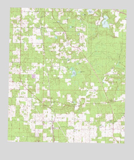
McAlpin, FL USGS Topographic Map
Click on map above to begin viewing in our Map Viewer.

This topographic map contains these locations and features:
Feature Name Type Latitude Longitude GNIS ID View Map
Bachelor LakeLakeN30.2331°W82.9346°278020View Map
Bandy LakeLakeN30.1990°W82.9266°278081View Map
Bethelehem ChurchChurchN30.1783°W82.9790°278561View Map
Bethlehem CemeteryCemeteryN30.1858°W82.9471°278563View Map
Beulah Hill ChurchChurchN30.2472°W82.9690°278594View Map
Blue LakeLakeN30.1896°W82.9305°279039View Map
Blume LakeLakeN30.1457°W82.8908°279090View Map
Brim PondLakeN30.2028°W82.9371°279403View Map
Button Bush PondLakeN30.1910°W82.9246°279747View Map
Crab LakeLakeN30.1994°W82.8834°280975View Map
Crawford LakeLakeN30.1627°W82.9290°281014View Map
Crawford Lake ChurchChurchN30.1605°W82.9279°281016View Map
Deep LakeLakeN30.1954°W82.8898°281433View Map
Dorman PondReservoirN30.2479°W82.9259°281684View Map
Dry LakeLakeN30.1403°W82.9040°281798View Map
Flag PondLakeN30.1817°W82.8969°282538View Map
Little River CemeteryCemeteryN30.1816°W82.8904°285784View Map
McAlpinPopulated PlaceN30.1391°W82.9518°286560View Map
McAlpin ChurchChurchN30.1377°W82.9287°286561View Map
McAlpin Post OfficePost OfficeN30.1393°W82.9516°2768015View Map
McAlpin Volunteer Fire DepartmentBuildingN30.1683°W82.9729°2644226View Map
McAlpin-Wellborn DivisionCivilN30.1749°W82.9094°1935837View Map
Moss Meadows AirportAirportN30.2398°W82.9060°2676662View Map
Mount Moriah ChurchChurchN30.2319°W82.9621°287237View Map
Mount Sinai ChurchChurchN30.1958°W82.9532°287315View Map
Mount Zion ChurchChurchN30.2324°W82.9654°287350View Map
PadlockPopulated PlaceN30.2313°W82.9665°295523View Map
Peacock LakeLakeN30.2380°W82.8976°288620View Map
Pine MountPopulated PlaceN30.1630°W82.9546°295094View Map
Pine Mount ChurchChurchN30.1577°W82.9240°301613View Map
Pretty PondReservoirN30.2450°W82.9215°289308View Map
Red Barn Acres AirportAirportN30.1761°W82.9978°309625View Map
Rocky HillSummitN30.1649°W82.8885°289906View Map
Sand PondReservoirN30.1940°W82.9332°290577View Map
Scott PondReservoirN30.2110°W82.9455°290765View Map
Suwannee CountyCivilN30.1956°W82.9915°295729View Map
Suwannee County Fire Rescue Station 2BuildingN30.1733°W82.9857°2644582View Map
Tiger LakeReservoirN30.2380°W82.9481°292283View Map
Tiger Lake ChurchChurchN30.2372°W82.9487°292284View Map
White LakeLakeN30.2478°W82.9137°293210View Map
WNFB-FM (Lake City)TowerN30.1291°W82.8801°309041View Map

Note: Coordinates in the location and feature list above are referenced to NAD83 datum.


Copyright (C) 2008-2024 Ryan Niemi / Sunset Dynamics ... All Rights Reserved