TopoQuest Logo
Do you find TopoQuest useful?
Help keep TopoQuest running and adding new maps/features by donating!
Bitcoin:  19c7KJd3qBynnjoSw5npx9KScwjBe4ifkT
Litecoin:  LXs6TkuXGGXo1vDsWCkWVdjQX94eUKd6ui
Home View Maps Find Maps Find Places Resources & Links


White Springs West, Florida Topographic Map

USGS Map Title: White Springs West, FL
USGS Map MRC: 30082C7
DRG (GeoTIFF) Download: o30082c7.tif


Neighboring USGS Topographic Map Quads:


  Hillcoat, FL  
30082D8
 

  Genoa, FL  
30082D7
 

  Benton, FL  
30082D6
 

  Live Oak East, FL  
30082C8
 

  White Springs West, FL  
30082C7
 

  White Springs East, FL  
30082C6
 

  McAlpin, FL  
30082B8
 

  Wellborn, FL  
30082B7
 

  Lake City West, FL  
30082B6


Map MRC Location:

N31°
W83°
N31°
W82°
H8 H7 H6 H5 H4 H3 H2 H1
G8 G7 G6 G5 G4 G3 G2 G1
F8 F7 F6 F5 F4 F3 F2 F1
E8 E7 E6 E5 E4 E3 E2 E1
D8 D7 D6 D5 D4 D3 D2 D1
C8 C7 C6 C5 C4 C3 C2 C1
B8 B7 B6 B5 B4 B3 B2 B1
A8 A7 A6 A5 A4 A3 A2 A1
N30°
W83°
N30°
W82°

White Springs West, FL USGS 1:24K Topographic Map Preview:
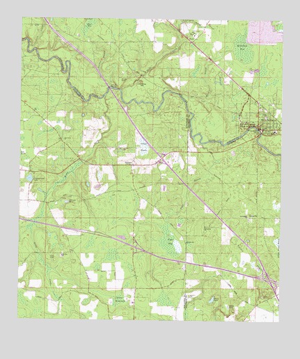
White Springs West, FL USGS Topographic Map
Click on map above to begin viewing in our Map Viewer.

This topographic map contains these locations and features:
Feature Name Type Latitude Longitude GNIS ID View Map
Black BaySwampN30.3719°W82.8430°278874View Map
Bullock Lookout TowerTowerN30.3541°W82.7790°279658View Map
Button Bush Pond (historical)LakeN30.3138°W82.8062°307379View Map
Campground LakeLakeN30.3085°W82.8701°279956View Map
Caney HammockSwampN30.2584°W82.8268°279980View Map
Church of God and PentecostaChurchN30.3350°W82.7607°2452764View Map
FacilPopulated PlaceN30.3658°W82.7915°295271View Map
Godbolt CemeteryCemeteryN30.2605°W82.7926°283133View Map
Greens PrairieSwampN30.3223°W82.8160°283423View Map
J Graham Black-Joseph W McAlpin BridgeBridgeN30.3294°W82.7596°303601View Map
Jackson PondReservoirN30.3381°W82.7675°284685View Map
Jerry BranchStreamN30.3644°W82.8710°284767View Map
Jim Mike HillSummitN30.3477°W82.8171°284805View Map
Johnson PondLakeN30.2990°W82.8522°284886View Map
Jones PondLakeN30.2766°W82.8569°284921View Map
Lane PondLakeN30.3294°W82.8449°285335View Map
Louisa PondLakeN30.3491°W82.8277°286133View Map
Louisa SpringSpringN30.3447°W82.8293°286134View Map
McCall BranchStreamN30.3727°W82.7996°286567View Map
McCallum BayReservoirN30.3658°W82.7683°286571View Map
Moore PondLakeN30.2589°W82.7820°287109View Map
Mount Olive ChurchChurchN30.2769°W82.8540°287264View Map
Mount Pleasant Baptist ChurchChurchN30.2934°W82.7657°2452765View Map
Mount Pleasant ChurchChurchN30.2936°W82.7654°287300View Map
Owens PondLakeN30.2561°W82.7745°288310View Map
Pasture Pond (historical)LakeN30.3133°W82.8007°307389View Map
Pine Grove ChurchChurchN30.3247°W82.8549°288844View Map
Pleasant Hill ChurchChurchN30.2824°W82.7946°289064View Map
Poucher BranchStreamN30.3452°W82.8315°289271View Map
Pouchers CornerPopulated PlaceN30.3144°W82.8212°294895View Map
Rocky CreekStreamN30.3436°W82.8343°289894View Map
Sailor Hole (historical)LakeN30.3155°W82.7965°307392View Map
Saint Lukes Freewill Baptist ChurchChurchN30.3374°W82.7554°2452766View Map
Sal Marie BranchStreamN30.3430°W82.7985°290411View Map
Salem ChurchChurchN30.2602°W82.7573°290416View Map
Sistrunk Pond (historical)LakeN30.2786°W82.8521°307393View Map
South Hamilton Elementary SchoolSchoolN30.3289°W82.7531°297864View Map
SpringvillePopulated PlaceN30.2927°W82.7635°295644View Map
Springville ChurchChurchN30.2888°W82.7857°291583View Map
Stephen Foster Folk Culture Center State ParkParkN30.3316°W82.7668°291679View Map
Sweet Home ChurchChurchN30.3730°W82.8449°291933View Map
Swift CreekStreamN30.3456°W82.8269°291961View Map
Swift Creek CemeteryCemeteryN30.3747°W82.7981°291963View Map
Swift Creek ChurchChurchN30.3738°W82.7974°291964View Map
Tiger BaySwampN30.2827°W82.8026°292266View Map
Tiger BranchStreamN30.3238°W82.7874°292270View Map
Town of White SpringsCivilN30.3318°W82.7564°2406880View Map
Turkey PrairieSwampN30.2747°W82.7648°292542View Map
White SpringsPopulated PlaceN30.3297°W82.7590°293230View Map
White Springs Christ Holiness ChurchChurchN30.3323°W82.7549°2452767View Map
White Springs Police DepartmentBuildingN30.3360°W82.7592°2333182View Map
White Springs Post OfficePost OfficeN30.3295°W82.7576°2452763View Map
White Springs Public LibraryBuildingN30.3401°W82.7606°2452762View Map
White Springs Volunteer Fire DepartmentBuildingN30.3300°W82.7579°2644088View Map
White Sulphur SpringSpringN30.3299°W82.7607°293234View Map
Zion Temple ChurchChurchN30.3555°W82.8237°293627View Map

Note: Coordinates in the location and feature list above are referenced to NAD83 datum.


Copyright (C) 2008-2025 Ryan Niemi / Sunset Dynamics ... All Rights Reserved