TopoQuest Logo
Do you find TopoQuest useful?
Help keep TopoQuest running and adding new maps/features by donating!
Bitcoin:  19c7KJd3qBynnjoSw5npx9KScwjBe4ifkT
Litecoin:  LXs6TkuXGGXo1vDsWCkWVdjQX94eUKd6ui
Home View Maps Find Maps Find Places Resources & Links


McIntosh, Alabama Topographic Map

USGS Map Title: McIntosh, AL
USGS Map MRC: 31088C1
DRG (GeoTIFF) Download: o31088c1.tif


Neighboring USGS Topographic Map Quads:


  Rutan, AL  
31088D2
 

  Wagarville, AL  
31088D1
 

  Prestwick, AL  
31087D8
 

  Seaboard, AL  
31088C2
 

  McIntosh, AL  
31088C1
 

  Gin House Island, AL  
31087C8
 

  Sims Chapel, AL  
31088B2
 

  Calvert, AL  
31088B1
 

  Bilbo Island, AL  
31087B8


Map MRC Location:

N32°
W89°
N32°
W88°
H8 H7 H6 H5 H4 H3 H2 H1
G8 G7 G6 G5 G4 G3 G2 G1
F8 F7 F6 F5 F4 F3 F2 F1
E8 E7 E6 E5 E4 E3 E2 E1
D8 D7 D6 D5 D4 D3 D2 D1
C8 C7 C6 C5 C4 C3 C2 C1
B8 B7 B6 B5 B4 B3 B2 B1
A8 A7 A6 A5 A4 A3 A2 A1
N31°
W89°
N31°
W88°

McIntosh, AL USGS 1:24K Topographic Map Preview:
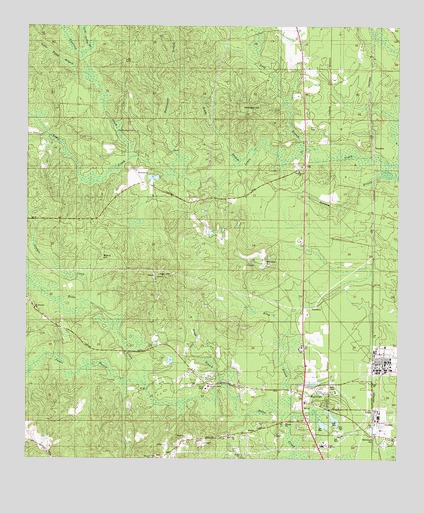
McIntosh, AL USGS Topographic Map
Click on map above to begin viewing in our Map Viewer.

This topographic map contains these locations and features:
Feature Name Type Latitude Longitude GNIS ID View Map
BASF Ciba Specialty Chemicals Fire and RescueBuildingN31.2762°W88.0069°2691476View Map
Beard HillSummitN31.3082°W88.1000°113694View Map
Birch BranchStreamN31.2627°W88.0381°114359View Map
Blocker HillSummitN31.3079°W88.0464°114498View Map
Boggy BranchStreamN31.2713°W88.0592°114659View Map
Brady BranchStreamN31.3357°W88.0547°114818View Map
Cathedral of PraiseChurchN31.3727°W88.0347°157550View Map
Cold Spring BranchStreamN31.3668°W88.1072°116394View Map
Copeland CreekStreamN31.3377°W88.0911°116607View Map
Cowpen CreekStreamN31.2957°W88.1039°116769View Map
Denham BranchStreamN31.3335°W88.0033°117226View Map
Fields CemeteryCemeteryN31.3627°W88.0228°157564View Map
Fields SchoolSchoolN31.3602°W88.0197°118269View Map
Frank W Boykin Elementary SchoolSchoolN31.2821°W88.0317°165477View Map
Happy Gospel ChurchChurchN31.2721°W88.0531°157570View Map
Harris CemeteryCemeteryN31.3457°W88.0303°119791View Map
HawthornPopulated PlaceN31.3332°W88.0883°156459View Map
Henson CreekStreamN31.3374°W88.0911°119985View Map
Henson DamDamN31.3335°W88.0750°129771View Map
Henson PondReservoirN31.3335°W88.0750°129770View Map
High HillSummitN31.3027°W88.0814°120055View Map
Lang's Chapel African Methodist Episcopal Zion ChurchChurchN31.2568°W88.0006°138938View Map
Little Boggy BranchStreamN31.3616°W88.1042°121711View Map
Long BranchStreamN31.3385°W88.0331°121994View Map
Magnolia CemeteryCemeteryN31.2510°W88.0811°157580View Map
Magnolia ChurchChurchN31.2510°W88.0817°138771View Map
McIntoshPopulated PlaceN31.2663°W88.0314°152280View Map
McIntosh AcademySchoolN31.2696°W88.0208°138777View Map
McIntosh CemeteryCemeteryN31.2627°W88.0300°157583View Map
McIntosh High SchoolSchoolN31.2541°W88.0250°150043View Map
McIntosh Police DepartmentBuildingN31.2676°W88.0308°2751712View Map
McIntosh Post OfficePost OfficeN31.2622°W88.0311°166957View Map
McIntosh Rescue SquadBuildingN31.2677°W88.0296°2331062View Map
McIntosh StationLocaleN31.2566°W88.0086°122563View Map
McIntosh United Methodist ChurchChurchN31.2621°W88.0303°154569View Map
McIntosh Volunteer Fire DepartmentBuildingN31.2666°W88.0298°2331057View Map
Memorial ChurchChurchN31.2568°W88.0547°138778View Map
Monger HillSummitN31.3513°W88.0528°122946View Map
Mount Pleasant Baptist ChurchChurchN31.2932°W88.1222°123355View Map
New Testament Tabernacle ChurchChurchN31.2703°W88.0643°2580493View Map
New WakefieldPopulated PlaceN31.3474°W88.0319°166081View Map
New Wakefield Post OfficePost OfficeN31.3474°W88.0319°169292View Map
Old Washington ChurchChurchN31.3452°W88.0894°157621View Map
Rattlesnake BranchStreamN31.3335°W88.0736°125447View Map
Reeds Chapel Baptist ChurchChurchN31.2704°W88.0639°138805View Map
Reeds Chapel CemeteryCemeteryN31.2702°W88.0639°157603View Map
Reeds Chapel SchoolSchoolN31.2685°W88.0592°125461View Map
Roberts ChurchChurchN31.2563°W88.0042°138808View Map
Rowell BranchStreamN31.2738°W88.0883°125994View Map
Saint Paul Baptist ChurchChurchN31.2571°W88.0183°157608View Map
Saint Paul CemeteryCemeteryN31.2568°W88.0183°157609View Map
Sand Pit (historical)LocaleN31.3660°W88.0106°138825View Map
Snow ChurchChurchN31.2516°W88.0528°154570View Map
ToinettePopulated PlaceN31.3396°W88.0083°157163View Map
Town of McIntoshCivilN31.2650°W88.0284°2406131View Map
Turkey ShoalsBarN31.2968°W88.0000°140146View Map
Washington Baptist ChurchChurchN31.3454°W88.0892°153895View Map
Washington CemeteryCemeteryN31.3454°W88.0897°157631View Map
Weaver SchoolSchoolN31.2504°W88.0819°128673View Map
Wiggins StadiumParkN31.2547°W88.0242°2356930View Map
Wilbert Reed ChurchChurchN31.2704°W88.0472°157635View Map

Note: Coordinates in the location and feature list above are referenced to NAD83 datum.


Copyright (C) 2008-2024 Ryan Niemi / Sunset Dynamics ... All Rights Reserved