TopoQuest Logo
Do you find TopoQuest useful?
Help keep TopoQuest running and adding new maps/features by donating!
Bitcoin:  19c7KJd3qBynnjoSw5npx9KScwjBe4ifkT
Litecoin:  LXs6TkuXGGXo1vDsWCkWVdjQX94eUKd6ui
Home View Maps Find Maps Find Places Resources & Links


McPaul, Iowa Topographic Map

USGS Map Title: McPaul, IA
USGS Map MRC: 40095G7
DRG (GeoTIFF) Download: o40095g7.tif


Neighboring USGS Topographic Map Quads:


  Murray, NE  
40095H8
 

  Rock Bluff, NE  
40095H7
 

  Tabor, IA  
40095H6
 

  Nehawka, NE  
40095G8
 

  McPaul, IA  
40095G7
 

  Tabor SW, IA  
40095G6
 

  Nebraska City NW, NE  
40095F8
 

  Nebraska City, NE  
40095F7
 

  Sidney, IA  
40095F6


Map MRC Location:

N41°
W96°
N41°
W95°
H8 H7 H6 H5 H4 H3 H2 H1
G8 G7 G6 G5 G4 G3 G2 G1
F8 F7 F6 F5 F4 F3 F2 F1
E8 E7 E6 E5 E4 E3 E2 E1
D8 D7 D6 D5 D4 D3 D2 D1
C8 C7 C6 C5 C4 C3 C2 C1
B8 B7 B6 B5 B4 B3 B2 B1
A8 A7 A6 A5 A4 A3 A2 A1
N40°
W96°
N40°
W95°

McPaul, IA USGS 1:24K Topographic Map Preview:
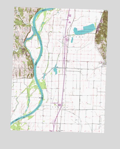
McPaul, IA USGS Topographic Map
Click on map above to begin viewing in our Map Viewer.

This topographic map contains these locations and features:
Feature Name Type Latitude Longitude GNIS ID View Map
Buchanan Post Office (historical)Post OfficeN40.8694°W95.8308°1949846View Map
Cleveland Post Office (historical)Post OfficeN40.8458°W95.8586°1897829View Map
East ChuteStreamN40.7642°W95.8617°828950View Map
Eaton CemeteryCemeteryN40.8037°W95.8610°829011View Map
Ervine CreekStreamN40.8178°W95.8456°829151View Map
Ervine School (historical)SchoolN40.8436°W95.8722°829152View Map
EurekaPopulated PlaceN40.7656°W95.8378°465447View Map
Forneys LakeLakeN40.8541°W95.7801°463358View Map
Forneys Lake State Wildlife Management AreaParkN40.8536°W95.7833°456679View Map
Interchange 15CrossingN40.7583°W95.8169°1949958View Map
Interchange 20CrossingN40.8222°W95.8064°1949957View Map
Jones PointCapeN40.8069°W95.8461°830409View Map
Kenosha CemeteryCemeteryN40.8749°W95.8431°830476View Map
Kings ChurchChurchN40.8742°W95.7550°458094View Map
McPaulLocaleN40.8225°W95.8033°1949844View Map
McPaulPopulated PlaceN40.8219°W95.8028°458937View Map
McPaul Post Office (historical)Post OfficeN40.8219°W95.8028°1949845View Map
McPaul State Wildlife Management AreaParkN40.8439°W95.8033°1949826View Map
Mule Slough DitchCanalN40.7544°W95.7808°459398View Map
Mustard LateralCanalN40.7886°W95.7842°459422View Map
Percival Census Designated PlaceCensusN40.7513°W95.8133°2583492View Map
Percival State Wildlife Management AreaParkN40.7778°W95.8114°1949825View Map
Plum CreekStreamN40.7981°W95.8394°460331View Map
Plum Creek DitchCanalN40.8142°W95.8003°460335View Map
Possum DitchCanalN40.7586°W95.7564°460371View Map
Rakes CreekStreamN40.8600°W95.8500°832440View Map
Sandy SloughStreamN40.8086°W95.8319°461419View Map
Scott State Wildlife Management AreaParkN40.8614°W95.8003°1949827View Map
Scott Township DitchCanalN40.8333°W95.8125°463359View Map
Skunk CreekStreamN40.8175°W95.7503°461662View Map
Township of ScottCivilN40.8432°W95.7762°468669View Map
Wa Con-Da LakeLakeN40.8435°W95.8533°834412View Map

Note: Coordinates in the location and feature list above are referenced to NAD83 datum.


Copyright (C) 2008-2025 Ryan Niemi / Sunset Dynamics ... All Rights Reserved