TopoQuest Logo
Do you find TopoQuest useful?
Help keep TopoQuest running and adding new maps/features by donating!
Bitcoin:  19c7KJd3qBynnjoSw5npx9KScwjBe4ifkT
Litecoin:  LXs6TkuXGGXo1vDsWCkWVdjQX94eUKd6ui
Home View Maps Find Maps Find Places Resources & Links


McQueeney, Texas Topographic Map

USGS Map Title: McQueeney, TX
USGS Map MRC: 29098E1
DRG (GeoTIFF) Download: o29098e1.tif


Neighboring USGS Topographic Map Quads:


  New Braunfels West, TX  
29098F2
 

  New Braunfels East, TX  
29098F1
 

  Geronimo, TX  
29097F8
 

  Marion, TX  
29098E2
 

  McQueeney, TX  
29098E1
 

  Seguin, TX  
29097E8
 

  Saint Hedwig, TX  
29098D2
 

  New Berlin, TX  
29098D1
 

  Thomas Springs, TX  
29097D8


Map MRC Location:

N30°
W99°
N30°
W98°
H8 H7 H6 H5 H4 H3 H2 H1
G8 G7 G6 G5 G4 G3 G2 G1
F8 F7 F6 F5 F4 F3 F2 F1
E8 E7 E6 E5 E4 E3 E2 E1
D8 D7 D6 D5 D4 D3 D2 D1
C8 C7 C6 C5 C4 C3 C2 C1
B8 B7 B6 B5 B4 B3 B2 B1
A8 A7 A6 A5 A4 A3 A2 A1
N29°
W99°
N29°
W98°

McQueeney, TX USGS 1:24K Topographic Map Preview:
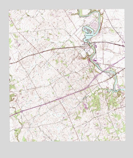
McQueeney, TX USGS Topographic Map
Click on map above to begin viewing in our Map Viewer.

This topographic map contains these locations and features:
Feature Name Type Latitude Longitude GNIS ID View Map
Boecker CemeteryCemeteryN29.5191°W98.0420°1330978View Map
Buzzard CreekStreamN29.5161°W98.1114°1331768View Map
Deadman CreekStreamN29.5469°W98.0100°1334146View Map
Garys Airport (historical)AirportN29.5863°W98.1200°1387153View Map
Guadalupe County Constable's Office Precinct 4BuildingN29.5721°W98.0392°2739374View Map
Guadalupe-Blanco River Authority Tp-3 DamDamN29.5943°W98.0407°1857396View Map
Hilda SidingPopulated PlaceN29.5883°W98.0706°1337769View Map
Interchange 601CrossingN29.5290°W98.1123°2470073View Map
Interchange 602CrossingN29.5405°W98.0723°2470074View Map
Interchange 603CrossingN29.5496°W98.0447°2470075View Map
Interchange 604CrossingN29.5608°W98.0323°2470076View Map
Interchange 605CrossingN29.5715°W98.0148°2470077View Map
Lake Breeze Ski LodgeLocaleN29.5969°W98.0453°1339485View Map
Lake McQueeneyReservoirN29.6020°W98.0399°1341275View Map
Lake PlacidReservoirN29.5660°W98.0158°1344157View Map
Long CreekStreamN29.6205°W98.0495°1340448View Map
McQueeneyPopulated PlaceN29.5922°W98.0333°1341274View Map
McQueeney Census Designated PlaceCensusN29.6000°W98.0440°2408804View Map
McQueeney Elementary SchoolSchoolN29.5961°W98.0483°2005495View Map
McQueeney Post OfficePost OfficeN29.5884°W98.0399°2731382View Map
McQueeney Volunteer Fire DepartmentBuildingN29.5898°W98.0378°2552295View Map
Morrison FallsPopulated PlaceN29.5644°W98.0203°1341945View Map
MuehlsvillePopulated PlaceN29.5500°W98.0433°1378714View Map
New Salem Baptist ChurchChurchN29.5144°W98.0589°2019499View Map
NoltePopulated PlaceN29.5747°W98.0311°1342651View Map
Saints Strip (historical)AirportN29.5525°W98.1033°1387154View Map
Santa ClaraPopulated PlaceN29.5119°W98.1214°1379028View Map
Santa Clara ChurchChurchN29.5130°W98.1183°1346625View Map
Santo Tomas CemeteryCemeteryN29.6027°W98.0095°1346690View Map
Treasure IslandIslandN29.6044°W98.0389°1348740View Map
WOAI-AM (San Antonio)TowerN29.5016°W98.1195°1385682View Map
Youngs CreekStreamN29.5816°W98.0364°1350703View Map
ZippPopulated PlaceN29.5597°W98.0164°1350768View Map

Note: Coordinates in the location and feature list above are referenced to NAD83 datum.


Copyright (C) 2008-2025 Ryan Niemi / Sunset Dynamics ... All Rights Reserved