TopoQuest Logo
Do you find TopoQuest useful?
Help keep TopoQuest running and adding new maps/features by donating!
Bitcoin:  19c7KJd3qBynnjoSw5npx9KScwjBe4ifkT
Litecoin:  LXs6TkuXGGXo1vDsWCkWVdjQX94eUKd6ui
Home View Maps Find Maps Find Places Resources & Links


Geronimo, Texas Topographic Map

USGS Map Title: Geronimo, TX
USGS Map MRC: 29097F8
DRG (GeoTIFF) Download: o29097f8.tif


Neighboring USGS Topographic Map Quads:


  Hunter, TX  
29098G1
 

  San Marcos South, TX  
29097G8
 

  Martindale, TX  
29097G7
 

  New Braunfels East, TX  
29098F1
 

  Geronimo, TX  
29097F8
 

  Kingsbury, TX  
29097F7
 

  McQueeney, TX  
29098E1
 

  Seguin, TX  
29097E8
 

  Darst Creek, TX  
29097E7


Map MRC Location:

N30°
W98°
N30°
W97°
H8 H7 H6 H5 H4 H3 H2 H1
G8 G7 G6 G5 G4 G3 G2 G1
F8 F7 F6 F5 F4 F3 F2 F1
E8 E7 E6 E5 E4 E3 E2 E1
D8 D7 D6 D5 D4 D3 D2 D1
C8 C7 C6 C5 C4 C3 C2 C1
B8 B7 B6 B5 B4 B3 B2 B1
A8 A7 A6 A5 A4 A3 A2 A1
N29°
W98°
N29°
W97°

Geronimo, TX USGS 1:24K Topographic Map Preview:
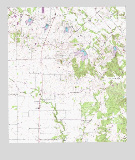
Geronimo, TX USGS Topographic Map
Click on map above to begin viewing in our Map Viewer.

This topographic map contains these locations and features:
Feature Name Type Latitude Longitude GNIS ID View Map
Alligator CreekStreamN29.6719°W97.9881°1377699View Map
Copperas Cove Public LibraryBuildingN29.7363°W97.9039°2015004View Map
GallePopulated PlaceN29.7383°W97.9142°1378340View Map
GeronimoPopulated PlaceN29.6630°W97.9669°1336502View Map
Geronimo Census Designated PlaceCensusN29.6728°W97.9686°2408292View Map
Geronimo Post OfficePost OfficeN29.6614°W97.9672°2731421View Map
Geronimo SpringsSpringN29.6586°W97.9586°1998566View Map
Geronimo Volunteer Fire DepartmentBuildingN29.6587°W97.9665°2552284View Map
Good Shepard Evangelical ChurchChurchN29.6463°W97.9536°2019513View Map
Harborth HillSummitN29.7099°W97.9794°1337329View Map
Jechow CemeteryCemeteryN29.7422°W97.8911°1338684View Map
LaubackPopulated PlaceN29.6283°W97.9403°1378568View Map
Long CreekStreamN29.7283°W97.9017°1374700View Map
Mesquite CreekStreamN29.7491°W97.9889°1341410View Map
Moltz AirportAirportN29.6870°W97.9956°1386729View Map
Navarro Elementary SchoolSchoolN29.6549°W97.9697°2005444View Map
Navarro High SchoolSchoolN29.6363°W97.9672°2005445View Map
Navarro Middle SchoolSchoolN29.6363°W97.9672°2005446View Map
Navarro SchoolSchoolN29.6572°W97.9675°1342384View Map
San Juan CemeteryCemeteryN29.6647°W97.9631°1346398View Map
Seguin North Division (historical)CensusN29.7086°W97.9222°1939184View Map
Silva ParkParkN29.6286°W97.9419°1347125View Map
Soil Conservation Service Site 11 DamDamN29.7086°W97.9186°1857397View Map
Soil Conservation Service Site 11 ReservoirReservoirN29.7083°W97.9201°1857398View Map
Soil Conservation Service Site 12 DamDamN29.7136°W97.8869°1857399View Map
Soil Conservation Service Site 12 ReservoirReservoirN29.7115°W97.8868°1857400View Map
Soil Conservation Service Site 6 DamDamN29.7386°W97.9753°1857401View Map
Soil Conservation Service Site 6 ReservoirReservoirN29.7384°W97.9768°1857402View Map
Soil Conservation Service Site 8 DamDamN29.7336°W97.9586°1857403View Map
Soil Conservation Service Site 8 ReservoirReservoirN29.7327°W97.9588°1857404View Map
Soil Conservation Service Site 9 DamDamN29.7319°W97.9386°1857405View Map
Soil Conservation Service Site 9 ReservoirReservoirN29.7295°W97.9378°1857406View Map
Texas No Name Number 46 DamDamN29.7369°W97.9886°1864939View Map
Wade CemeteryCemeteryN29.7405°W97.8914°1349338View Map

Note: Coordinates in the location and feature list above are referenced to NAD83 datum.


Copyright (C) 2008-2025 Ryan Niemi / Sunset Dynamics ... All Rights Reserved