TopoQuest Logo
Do you find TopoQuest useful?
Help keep TopoQuest running and adding new maps/features by donating!
Bitcoin:  19c7KJd3qBynnjoSw5npx9KScwjBe4ifkT
Litecoin:  LXs6TkuXGGXo1vDsWCkWVdjQX94eUKd6ui
Home View Maps Find Maps Find Places Resources & Links


Bearden, Arkansas Topographic Map

USGS Map Title: Bearden, AR
USGS Map MRC: 33092F5
DRG (GeoTIFF) Download: o33092f5.tif


Neighboring USGS Topographic Map Quads:


  Holly Springs, AR  
33092G6
 

  Hopeville, AR  
33092G5
 

  Fordyce, AR  
33092G4
 

  Eagle Mills, AR  
33092F6
 

  Bearden, AR  
33092F5
 

  Chambersville, AR  
33092F4
 

  East Camden, AR  
33092E6
 

  Woodberry, AR  
33092E5
 

  Hampton, AR  
33092E4


Map MRC Location:

N34°
W93°
N34°
W92°
H8 H7 H6 H5 H4 H3 H2 H1
G8 G7 G6 G5 G4 G3 G2 G1
F8 F7 F6 F5 F4 F3 F2 F1
E8 E7 E6 E5 E4 E3 E2 E1
D8 D7 D6 D5 D4 D3 D2 D1
C8 C7 C6 C5 C4 C3 C2 C1
B8 B7 B6 B5 B4 B3 B2 B1
A8 A7 A6 A5 A4 A3 A2 A1
N33°
W93°
N33°
W92°

Bearden, AR USGS 1:24K Topographic Map Preview:
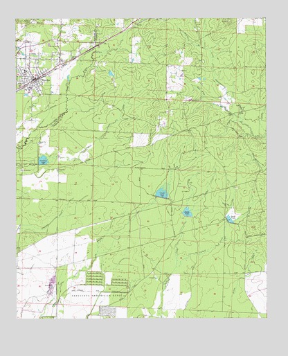
Bearden, AR USGS Topographic Map
Click on map above to begin viewing in our Map Viewer.

This topographic map contains these locations and features:
Feature Name Type Latitude Longitude GNIS ID View Map
Accession ChurchChurchN33.7334°W92.5971°45775View Map
BeardenPopulated PlaceN33.7246°W92.6157°46250View Map
Bearden Ambulance ServiceBuildingN33.7259°W92.6161°2119040View Map
Bearden Elementary SchoolSchoolN33.7275°W92.6206°64361View Map
Bearden High SchoolSchoolN33.7305°W92.6213°64362View Map
Bearden Middle SchoolSchoolN33.7285°W92.6206°2039340View Map
Bearden Police DepartmentBuildingN33.7252°W92.6162°2118823View Map
Bearden Volunteer Fire DepartmentBuildingN33.7257°W92.6161°2116119View Map
Bests (historical)Populated PlaceN33.7312°W92.6029°64363View Map
City of BeardenCivilN33.7279°W92.6184°2403830View Map
Cordell CreekStreamN33.6465°W92.5454°48040View Map
Covington PondReservoirN33.6910°W92.6117°80736View Map
Covington Pond DamDamN33.6901°W92.6152°80735View Map
HarlowPopulated PlaceN33.7482°W92.5671°57884View Map
Harlow CemeteryCemeteryN33.7495°W92.5710°49860View Map
Harmony Baptist ChurchChurchN33.7307°W92.5499°77123View Map
Jack Nutt BranchStreamN33.7068°W92.5121°50540View Map
Joe Jack CreekStreamN33.6918°W92.5940°50659View Map
Macedonia ChurchChurchN33.7326°W92.6027°51564View Map
Middle PondReservoirN33.6692°W92.5396°80740View Map
Middle Pond DamDamN33.6668°W92.5402°80739View Map
Moss CemeteryCemeteryN33.7484°W92.6160°52238View Map
Moss Hill CemeteryCemeteryN33.7490°W92.6174°52240View Map
Mount Olive ChurchChurchN33.7387°W92.6046°52341View Map
North PondReservoirN33.6770°W92.5523°80738View Map
North Pond DamDamN33.6751°W92.5535°80737View Map
Peters BranchStreamN33.7373°W92.5293°53303View Map
Providence ChurchChurchN33.7159°W92.5335°53825View Map
South PondReservoirN33.6662°W92.5185°80742View Map
South Pond DamDamN33.6651°W92.5202°80741View Map
Township of Huey (historical)CivilN33.7112°W92.5585°63702View Map
Township of Locust Bayou (historical)CivilN33.6876°W92.6002°63705View Map
Unorganized Territory of Shumaker (historical)CensusN33.6279°W92.5877°63709View Map

Note: Coordinates in the location and feature list above are referenced to NAD83 datum.


Copyright (C) 2008-2025 Ryan Niemi / Sunset Dynamics ... All Rights Reserved